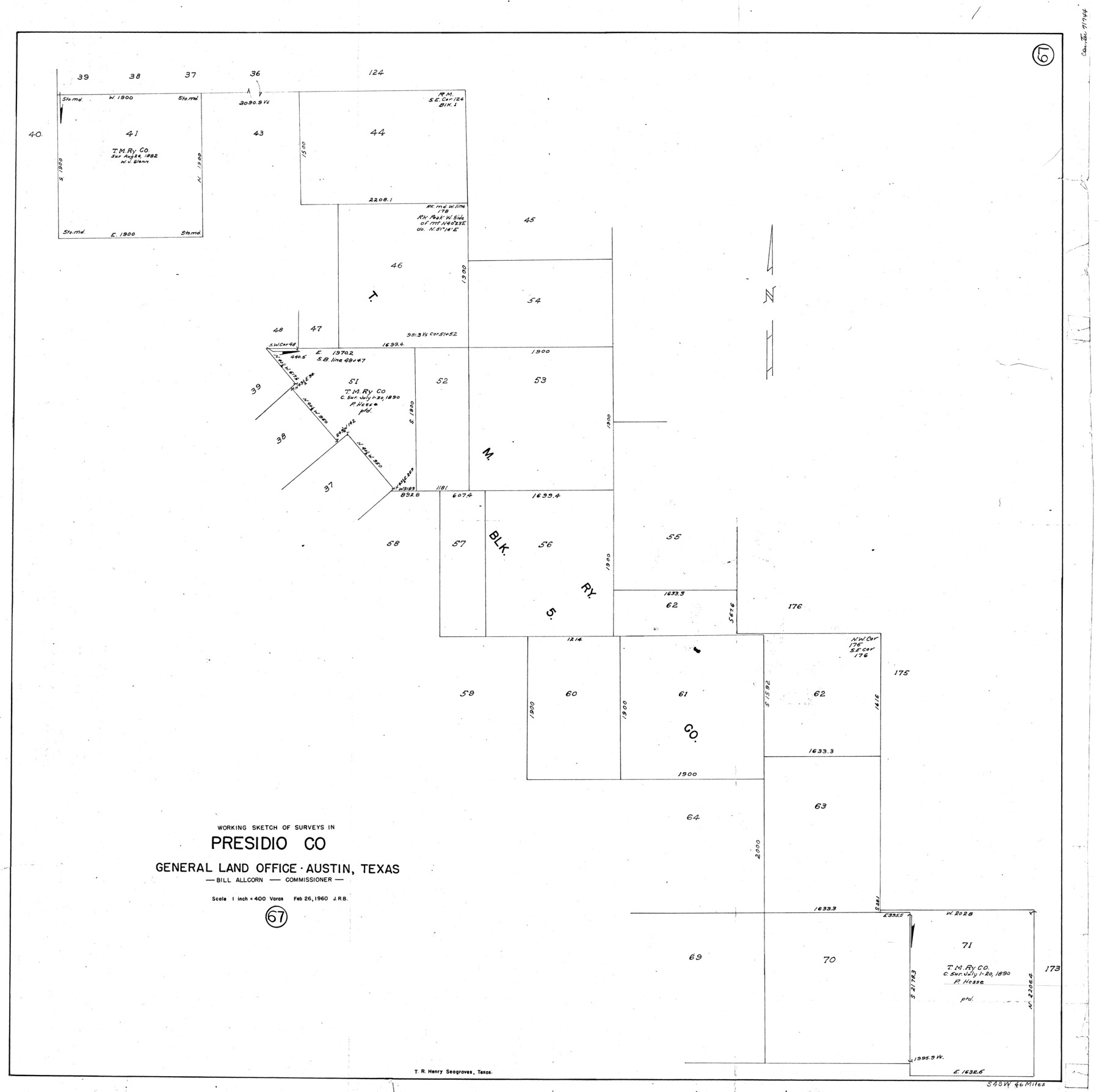
Presidio County Working Sketch 67
-
Map/Doc
71744
-
Collection
General Map Collection
-
Object Dates
2/26/1960 (Creation Date)
-
Counties
Presidio
-
Subjects
Surveying Working Sketch
-
Height x Width
36.2 x 36.5 inches
92.0 x 92.7 cm
-
Scale
1" = 400 varas
Part of: General Map Collection
Stonewall County Sketch File 17

Print $6.00
- Digital $50.00
Stonewall County Sketch File 17
1902
Size 16.5 x 10.6 inches
Map/Doc 37274
Galveston County NRC Article 33.136 Location Key Sheet

Print $20.00
- Digital $50.00
Galveston County NRC Article 33.136 Location Key Sheet
1974
Size 27.0 x 23.0 inches
Map/Doc 77025
Flight Mission No. BQR-22K, Frame 42, Brazoria County

Print $20.00
- Digital $50.00
Flight Mission No. BQR-22K, Frame 42, Brazoria County
1953
Size 18.9 x 22.7 inches
Map/Doc 84126
Hutchinson County Sketch File 36

Print $10.00
- Digital $50.00
Hutchinson County Sketch File 36
1941
Size 11.2 x 8.9 inches
Map/Doc 27270
Jackson County Sketch File 23

Print $6.00
- Digital $50.00
Jackson County Sketch File 23
1949
Size 11.2 x 8.6 inches
Map/Doc 27703
Dimmit County Boundary File 1

Print $8.00
- Digital $50.00
Dimmit County Boundary File 1
Size 12.9 x 7.9 inches
Map/Doc 52560
Hopkins County Sketch File 2

Print $28.00
- Digital $50.00
Hopkins County Sketch File 2
1845
Size 11.1 x 7.9 inches
Map/Doc 26678
Hockley County

Print $20.00
- Digital $50.00
Hockley County
1954
Size 41.0 x 36.4 inches
Map/Doc 77313
Throckmorton County Working Sketch 7

Print $20.00
- Digital $50.00
Throckmorton County Working Sketch 7
1956
Size 25.8 x 32.0 inches
Map/Doc 62116
Gaines County Rolled Sketch 7

Print $40.00
- Digital $50.00
Gaines County Rolled Sketch 7
1915
Size 35.7 x 54.0 inches
Map/Doc 9014
Brewster County Sketch File NS-8

Print $311.00
- Digital $50.00
Brewster County Sketch File NS-8
Size 15.0 x 9.1 inches
Map/Doc 15999
San Antonio Business District

Print $20.00
- Digital $50.00
San Antonio Business District
1935
Size 17.4 x 14.8 inches
Map/Doc 95955
You may also like
[Copy of a portion of] The Coast & Bays of Western Texas, St. Joseph's and Mustang Islands from Actual Survey, the Remainder from County Maps, Etc.
![72769, [Copy of a portion of] The Coast & Bays of Western Texas, St. Joseph's and Mustang Islands from Actual Survey, the Remainder from County Maps, Etc., General Map Collection](https://historictexasmaps.com/wmedia_w700/maps/72769.tif.jpg)
Print $20.00
- Digital $50.00
[Copy of a portion of] The Coast & Bays of Western Texas, St. Joseph's and Mustang Islands from Actual Survey, the Remainder from County Maps, Etc.
1857
Size 25.9 x 18.3 inches
Map/Doc 72769
Jeff Davis County Rolled Sketch 12

Print $20.00
- Digital $50.00
Jeff Davis County Rolled Sketch 12
1920
Size 24.8 x 18.1 inches
Map/Doc 6365
Navasota River, Springfield Sheet

Print $20.00
- Digital $50.00
Navasota River, Springfield Sheet
1934
Size 41.5 x 37.8 inches
Map/Doc 65074
Map of Chicago, Rock Island & Texas Railway

Print $20.00
- Digital $50.00
Map of Chicago, Rock Island & Texas Railway
1892
Size 22.4 x 44.0 inches
Map/Doc 64443
[Texas Department of Corrections Prison Farm Locations]
![78638, [Texas Department of Corrections Prison Farm Locations], General Map Collection](https://historictexasmaps.com/wmedia_w700/maps/78638.tif.jpg)
Print $40.00
- Digital $50.00
[Texas Department of Corrections Prison Farm Locations]
Size 43.0 x 54.0 inches
Map/Doc 78638
[S. M. Walker, D. P. Allen, J. C. Guinn, J. R. Lamar and surrounding surveys]
![90334, [S. M. Walker, D. P. Allen, J. C. Guinn, J. R. Lamar and surrounding surveys], Twichell Survey Records](https://historictexasmaps.com/wmedia_w700/maps/90334-1.tif.jpg)
Print $3.00
- Digital $50.00
[S. M. Walker, D. P. Allen, J. C. Guinn, J. R. Lamar and surrounding surveys]
1912
Size 9.7 x 11.2 inches
Map/Doc 90334
Angelina County Rolled Sketch 5

Print $40.00
- Digital $50.00
Angelina County Rolled Sketch 5
1993
Size 36.0 x 75.3 inches
Map/Doc 9328
Grayson County Working Sketch 15

Print $20.00
- Digital $50.00
Grayson County Working Sketch 15
1953
Size 24.8 x 20.6 inches
Map/Doc 63254

[I. & G. N. Block 1]
![91592, [I. & G. N. Block 1], Twichell Survey Records](https://historictexasmaps.com/wmedia_w700/maps/91592-1.tif.jpg)
Print $20.00
- Digital $50.00
[I. & G. N. Block 1]
Size 17.2 x 18.1 inches
Map/Doc 91592
Harrison County Rolled Sketch 4

Print $20.00
- Digital $50.00
Harrison County Rolled Sketch 4
1938
Size 28.2 x 34.9 inches
Map/Doc 6150
Upton County Working Sketch 54

Print $20.00
- Digital $50.00
Upton County Working Sketch 54
1983
Size 23.2 x 37.7 inches
Map/Doc 69551