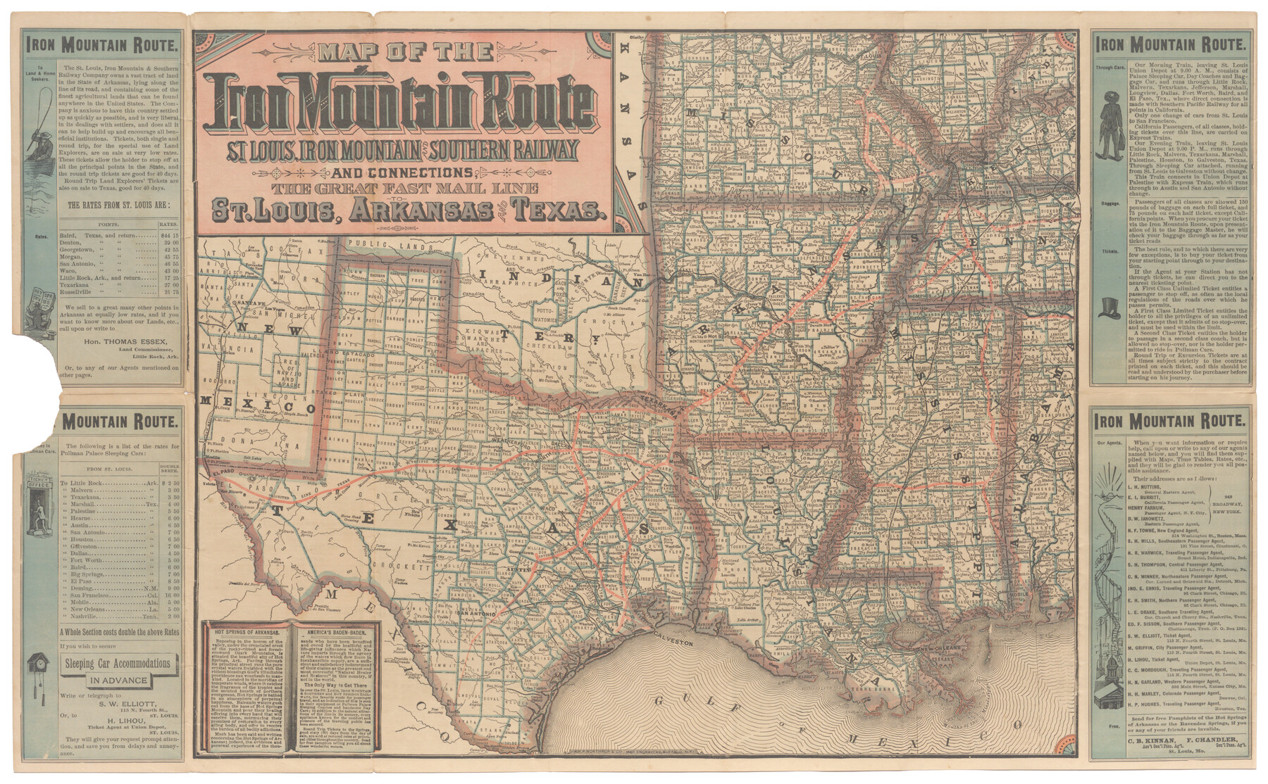
Map of the Iron Mountain Route - St. Louis, Iron Mountain and Southern Railway and connections, the great fast mail line to St. Louis, Arkansas and Texas
Iron Mountain Route
-
Map/Doc
95787
-
Collection
Cobb Digital Map Collection
-
Object Dates
1882 (Creation Date)
-
People and Organizations
Wm. P. Northrup & Co. (Printer)
-
Subjects
Railroads
-
Height x Width
14.9 x 24.1 inches
37.9 x 61.2 cm
-
Medium
digital image
-
Comments
Courtesy of John & Diana Cobb.
To view timetables and other information printed on verso, click "Download PDF" link above.
Part of: Cobb Digital Map Collection
Sunny San Antonio - The Winter Playground of America

Sunny San Antonio - The Winter Playground of America
1920
Size 9.4 x 7.9 inches
Map/Doc 97040
[Map of Texas]
![95882, [Map of Texas], Cobb Digital Map Collection - 1](https://historictexasmaps.com/wmedia_w700/maps/95882.tif.jpg)
Print $20.00
- Digital $50.00
[Map of Texas]
1908
Size 18.5 x 18.7 inches
Map/Doc 95882
County Map of the Pan-Handle of Texas and the line of the Texas Pan-Handle Route

Print $20.00
- Digital $50.00
County Map of the Pan-Handle of Texas and the line of the Texas Pan-Handle Route
1900
Size 7.2 x 10.3 inches
Map/Doc 95888

Santa Fe Lines - Texas, Oklahoma, and Louisiana

Print $20.00
- Digital $50.00
Santa Fe Lines - Texas, Oklahoma, and Louisiana
1923
Size 9.3 x 8.3 inches
Map/Doc 96595
A Geographically Correct County Map of States Traversed by the St. Louis, Iron Mountain & Southern Railway and its Connections

Print $20.00
- Digital $50.00
A Geographically Correct County Map of States Traversed by the St. Louis, Iron Mountain & Southern Railway and its Connections
1876
Size 18.6 x 15.9 inches
Map/Doc 95781
Map of the Texas & Pacific Railway and connections

Print $20.00
- Digital $50.00
Map of the Texas & Pacific Railway and connections
1892
Size 22.5 x 31.9 inches
Map/Doc 95761
Map of Texas with population and location of principal towns and cities according to latest reliable statistics

Print $20.00
- Digital $50.00
Map of Texas with population and location of principal towns and cities according to latest reliable statistics
1909
Size 18.3 x 20.2 inches
Map/Doc 95874
Map of the Texas & Pacific Railway and connections

Print $20.00
- Digital $50.00
Map of the Texas & Pacific Railway and connections
1899
Size 17.9 x 36.6 inches
Map/Doc 95765

Map of Texas with population and location of principal towns and cities according to latest reliable statistics

Print $20.00
- Digital $50.00
Map of Texas with population and location of principal towns and cities according to latest reliable statistics
1910
Size 19.1 x 20.6 inches
Map/Doc 95878
The Rand McNally New Commercial Atlas Map of Texas

Print $20.00
- Digital $50.00
The Rand McNally New Commercial Atlas Map of Texas
1915
Size 28.5 x 40.3 inches
Map/Doc 95862
You may also like
Starr County Rolled Sketch 29

Print $20.00
- Digital $50.00
Starr County Rolled Sketch 29
1857
Size 35.1 x 30.0 inches
Map/Doc 7812
Aransas Pass to Baffin Bay

Print $20.00
- Digital $50.00
Aransas Pass to Baffin Bay
1973
Size 42.0 x 35.1 inches
Map/Doc 73418
[Corner of Blocks H1, K5, Z3, S, and Block 8]
![91470, [Corner of Blocks H1, K5, Z3, S, and Block 8], Twichell Survey Records](https://historictexasmaps.com/wmedia_w700/maps/91470-1.tif.jpg)
Print $3.00
- Digital $50.00
[Corner of Blocks H1, K5, Z3, S, and Block 8]
Size 11.9 x 14.6 inches
Map/Doc 91470
Coke County Rolled Sketch 19A

Print $20.00
- Digital $50.00
Coke County Rolled Sketch 19A
1954
Size 19.9 x 24.8 inches
Map/Doc 5520
Flight Mission No. CRE-3R, Frame 40, Jackson County

Print $20.00
- Digital $50.00
Flight Mission No. CRE-3R, Frame 40, Jackson County
1956
Size 18.6 x 22.3 inches
Map/Doc 85387
Kinney County Working Sketch 27

Print $20.00
- Digital $50.00
Kinney County Working Sketch 27
1956
Size 23.1 x 25.1 inches
Map/Doc 70209

Map of Texas and the Country Adjacent: Compiled in the Bureau of the Corps of Topographical Engineers from the best Authorities

Print $20.00
- Digital $50.00
Map of Texas and the Country Adjacent: Compiled in the Bureau of the Corps of Topographical Engineers from the best Authorities
1844
Size 17.0 x 23.4 inches
Map/Doc 95747
Hays County Working Sketch 8

Print $20.00
- Digital $50.00
Hays County Working Sketch 8
1942
Size 27.1 x 30.9 inches
Map/Doc 66082
Bastrop County Sketch File 1a

Print $4.00
- Digital $50.00
Bastrop County Sketch File 1a
Size 8.4 x 12.8 inches
Map/Doc 14040
Flight Mission No. DCL-6C, Frame 93, Kenedy County

Print $20.00
- Digital $50.00
Flight Mission No. DCL-6C, Frame 93, Kenedy County
1943
Size 18.6 x 22.3 inches
Map/Doc 85923
Colorado County Working Sketch 19

Print $20.00
- Digital $50.00
Colorado County Working Sketch 19
1958
Size 25.3 x 19.1 inches
Map/Doc 68119