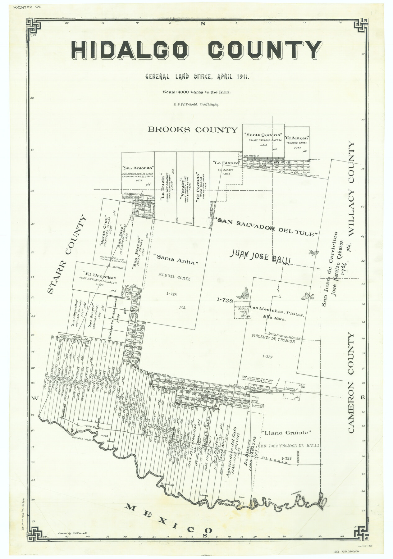
Hidalgo County
-
Map/Doc
66863
-
Collection
General Map Collection
-
Object Dates
1911 (Creation Date)
-
People and Organizations
Texas General Land Office (Publisher)
H.M. McDonald (Compiler)
H.M. McDonald (Draftsman)
-
Counties
Hidalgo
-
Subjects
County
-
Height x Width
42.1 x 29.6 inches
106.9 x 75.2 cm
-
Comments
Traced by O. O. Terrell.
Part of: General Map Collection
Pecos County Sketch File 42

Print $30.00
- Digital $50.00
Pecos County Sketch File 42
1919
Size 9.1 x 8.0 inches
Map/Doc 33735
Jefferson County Rolled Sketch 61C

Print $20.00
- Digital $50.00
Jefferson County Rolled Sketch 61C
1928
Size 27.2 x 40.3 inches
Map/Doc 6412
Flight Mission No. CUG-3P, Frame 135, Kleberg County

Print $20.00
- Digital $50.00
Flight Mission No. CUG-3P, Frame 135, Kleberg County
1956
Size 18.7 x 22.3 inches
Map/Doc 86270
Ride the Texas Mountain Trail [Recto]
![94164, Ride the Texas Mountain Trail [Recto], General Map Collection](https://historictexasmaps.com/wmedia_w700/maps/94164.tif.jpg)
Ride the Texas Mountain Trail [Recto]
1968
Size 18.4 x 24.3 inches
Map/Doc 94164
Stephens County Sketch File 12a

Print $23.00
- Digital $50.00
Stephens County Sketch File 12a
Size 18.2 x 11.2 inches
Map/Doc 37061
Dallas County Boundary File 4

Print $38.00
- Digital $50.00
Dallas County Boundary File 4
Size 8.9 x 3.9 inches
Map/Doc 52123
Prison Property, Walker County

Print $20.00
- Digital $50.00
Prison Property, Walker County
Size 32.6 x 22.7 inches
Map/Doc 94279
Hardin County Sketch File 45

Print $2.00
- Digital $50.00
Hardin County Sketch File 45
Size 8.3 x 6.2 inches
Map/Doc 25195
Potter County Rolled Sketch 11

Print $20.00
- Digital $50.00
Potter County Rolled Sketch 11
1986
Size 21.6 x 27.4 inches
Map/Doc 7324
E. N. Gustafson's survey of Northern Portion of Lake Austin, Matagorda Co., TX

Print $40.00
- Digital $50.00
E. N. Gustafson's survey of Northern Portion of Lake Austin, Matagorda Co., TX
1926
Size 43.0 x 52.5 inches
Map/Doc 2068
Duval County Sketch File 54

Print $20.00
- Digital $50.00
Duval County Sketch File 54
1937
Size 19.0 x 26.4 inches
Map/Doc 11403
Upshur County Rolled Sketch 2

Print $20.00
- Digital $50.00
Upshur County Rolled Sketch 2
1954
Size 26.8 x 23.4 inches
Map/Doc 8061
You may also like
Marion County Working Sketch 38

Print $20.00
- Digital $50.00
Marion County Working Sketch 38
1991
Size 35.5 x 39.9 inches
Map/Doc 70814
Jeff Davis County Rolled Sketch 1

Print $20.00
- Digital $50.00
Jeff Davis County Rolled Sketch 1
1882
Size 23.0 x 43.2 inches
Map/Doc 6359
Houston Ship Channel, Atkinson Island to Alexander Island

Print $40.00
- Digital $50.00
Houston Ship Channel, Atkinson Island to Alexander Island
1972
Size 36.9 x 50.0 inches
Map/Doc 69901
General Highway Map, Dallam County, Hartley County, Texas

Print $20.00
General Highway Map, Dallam County, Hartley County, Texas
1940
Size 18.3 x 25.1 inches
Map/Doc 79065
Brazos River, Clodine Sheet

Print $4.00
- Digital $50.00
Brazos River, Clodine Sheet
1930
Size 21.8 x 24.6 inches
Map/Doc 65287
Freestone County Sketch File 16

Print $4.00
- Digital $50.00
Freestone County Sketch File 16
Size 6.4 x 8.7 inches
Map/Doc 23072
Hutchinson County Rolled Sketch 13

Print $20.00
- Digital $50.00
Hutchinson County Rolled Sketch 13
Size 17.8 x 16.7 inches
Map/Doc 6283
United States - Gulf Coast Texas - Northern part of Laguna Madre

Print $20.00
- Digital $50.00
United States - Gulf Coast Texas - Northern part of Laguna Madre
1941
Size 18.4 x 24.2 inches
Map/Doc 72936
Aransas County Rolled Sketch 22
Print $40.00
- Digital $50.00
Aransas County Rolled Sketch 22
1980
Size 40.1 x 71.7 inches
Map/Doc 8416
Bastrop County Working Sketch 7

Print $20.00
- Digital $50.00
Bastrop County Working Sketch 7
1930
Size 32.7 x 29.7 inches
Map/Doc 67307
Orange County Working Sketch 21

Print $20.00
- Digital $50.00
Orange County Working Sketch 21
1933
Size 27.0 x 28.1 inches
Map/Doc 71353
General Highway Map, Rains County, Wood County, Texas

Print $20.00
General Highway Map, Rains County, Wood County, Texas
1939
Size 18.2 x 24.8 inches
Map/Doc 79223