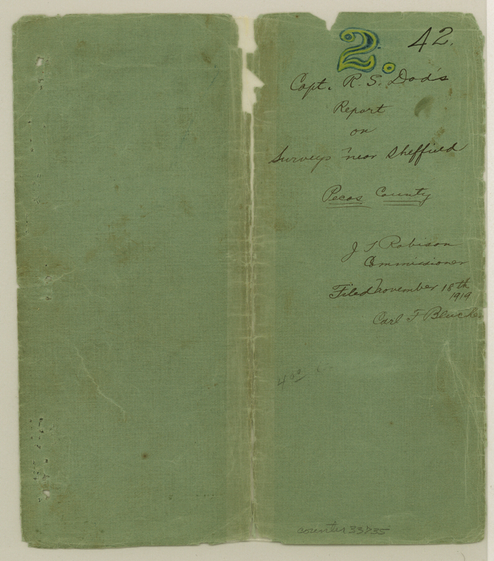
Pecos County Sketch File 42
[Report on surveys near Sheffield]
-
Map/Doc
33735
-
Collection
General Map Collection
-
Object Dates
1919/1/16 (Creation Date)
1919/11/18 (File Date)
1919/1/16 (Correspondence Date)
1918 (Correspondence Date)
-
People and Organizations
Captain R.S. Dod (Surveyor/Engineer)
-
Counties
Pecos
-
Subjects
Surveying Sketch File
-
Height x Width
9.1 x 8.0 inches
23.1 x 20.3 cm
-
Medium
multi-page, multi-format
-
Features
Sheffield
Pecos River
Fort Lancaster
Pecos Spring
School House
Part of: General Map Collection
Hardin County Sketch File 9

Print $4.00
- Digital $50.00
Hardin County Sketch File 9
1865
Size 12.4 x 8.2 inches
Map/Doc 25106
[Map of Line Dividing Fannin and Nacogdoches Districts]
![3134, [Map of Line Dividing Fannin and Nacogdoches Districts], General Map Collection](https://historictexasmaps.com/wmedia_w700/maps/3134.tif.jpg)
Print $20.00
- Digital $50.00
[Map of Line Dividing Fannin and Nacogdoches Districts]
1850
Size 35.6 x 40.8 inches
Map/Doc 3134
Kimble County Sketch File B

Print $22.00
- Digital $50.00
Kimble County Sketch File B
Size 14.3 x 12.7 inches
Map/Doc 28963
Throckmorton County Sketch File 6a

Print $20.00
- Digital $50.00
Throckmorton County Sketch File 6a
1897
Size 14.5 x 12.7 inches
Map/Doc 38089
Burnet County Sketch File 42

Print $28.00
- Digital $50.00
Burnet County Sketch File 42
1950
Size 9.9 x 8.8 inches
Map/Doc 16760
Brazoria County Sketch File 41

Print $40.00
- Digital $50.00
Brazoria County Sketch File 41
1939
Size 19.5 x 26.6 inches
Map/Doc 10960
Hansford County Working Sketch 3

Print $20.00
- Digital $50.00
Hansford County Working Sketch 3
1940
Size 20.5 x 16.5 inches
Map/Doc 63375
Kerr County Working Sketch 14

Print $20.00
- Digital $50.00
Kerr County Working Sketch 14
1952
Size 26.5 x 24.5 inches
Map/Doc 70045
PSL Field Notes for Block A19 in Andrews County, C45 in Andrews and Gaines Counties, C31 in Dawson and Gaines Counties, C34 in Terry and Gaines Counties, C35 in Yoakum and Gaines Counties, and Blocks C30, C32, C33, C43, and C44 in Gaines County

PSL Field Notes for Block A19 in Andrews County, C45 in Andrews and Gaines Counties, C31 in Dawson and Gaines Counties, C34 in Terry and Gaines Counties, C35 in Yoakum and Gaines Counties, and Blocks C30, C32, C33, C43, and C44 in Gaines County
Map/Doc 81643
[Location Survey of the Southern Kansas Railway, Kiowa Extension from a point in Drake's Location, in Indian Territory 100 miles from south line of Kansas, continuing up Wolf Creek and South Canadian River to Cottonwood Creek in Hutchinson County]
![88841, [Location Survey of the Southern Kansas Railway, Kiowa Extension from a point in Drake's Location, in Indian Territory 100 miles from south line of Kansas, continuing up Wolf Creek and South Canadian River to Cottonwood Creek in Hutchinson County], General Map Collection](https://historictexasmaps.com/wmedia_w700/maps/88841.tif.jpg)
Print $20.00
- Digital $50.00
[Location Survey of the Southern Kansas Railway, Kiowa Extension from a point in Drake's Location, in Indian Territory 100 miles from south line of Kansas, continuing up Wolf Creek and South Canadian River to Cottonwood Creek in Hutchinson County]
1886
Size 39.1 x 42.0 inches
Map/Doc 88841
Presidio County Rolled Sketch 84

Print $20.00
- Digital $50.00
Presidio County Rolled Sketch 84
1942
Size 22.7 x 33.1 inches
Map/Doc 9779
Hood County Working Sketch 8

Print $20.00
- Digital $50.00
Hood County Working Sketch 8
1971
Size 30.1 x 37.8 inches
Map/Doc 66202
You may also like
Denton County Working Sketch 38

Print $20.00
- Digital $50.00
Denton County Working Sketch 38
2010
Size 23.4 x 29.5 inches
Map/Doc 89571
Cameron County Rolled Sketch 28

Print $40.00
- Digital $50.00
Cameron County Rolled Sketch 28
1986
Size 36.5 x 48.3 inches
Map/Doc 8575
Flight Mission No. DQO-7K, Frame 99, Galveston County

Print $20.00
- Digital $50.00
Flight Mission No. DQO-7K, Frame 99, Galveston County
1952
Size 18.7 x 22.5 inches
Map/Doc 85114
Outer Continental Shelf Leasing Maps (Louisiana Offshore Operations)

Print $20.00
- Digital $50.00
Outer Continental Shelf Leasing Maps (Louisiana Offshore Operations)
1959
Size 17.8 x 14.0 inches
Map/Doc 76100
Hemphill County Sketch File 9

Print $26.00
- Digital $50.00
Hemphill County Sketch File 9
1955
Size 11.0 x 8.8 inches
Map/Doc 26312
General Highway Map, Marion County, Texas

Print $20.00
General Highway Map, Marion County, Texas
1940
Size 18.3 x 24.7 inches
Map/Doc 79184
Hartley County Sketch File 2

Print $22.00
- Digital $50.00
Hartley County Sketch File 2
Size 8.9 x 13.6 inches
Map/Doc 26085
Sutton County Working Sketch 40

Print $20.00
- Digital $50.00
Sutton County Working Sketch 40
1948
Size 34.9 x 28.3 inches
Map/Doc 62383
Kinney County Working Sketch 58

Print $20.00
- Digital $50.00
Kinney County Working Sketch 58
1996
Size 36.1 x 31.7 inches
Map/Doc 70240
[Capitol Lands in Lamb County]
![90996, [Capitol Lands in Lamb County], Twichell Survey Records](https://historictexasmaps.com/wmedia_w700/maps/90996-1.tif.jpg)
Print $20.00
- Digital $50.00
[Capitol Lands in Lamb County]
1903
Size 31.0 x 11.8 inches
Map/Doc 90996
Map No. 1 - Rio Bravo del Norte section of boundary between the United States & Mexico agreed upon by the Joint Commission under the Treaty of Guadalupe Hidalgo

Print $20.00
- Digital $50.00
Map No. 1 - Rio Bravo del Norte section of boundary between the United States & Mexico agreed upon by the Joint Commission under the Treaty of Guadalupe Hidalgo
1852
Size 18.4 x 27.0 inches
Map/Doc 72866
Delta County Sketch File 2

Print $4.00
- Digital $50.00
Delta County Sketch File 2
1871
Size 8.4 x 13.2 inches
Map/Doc 20670