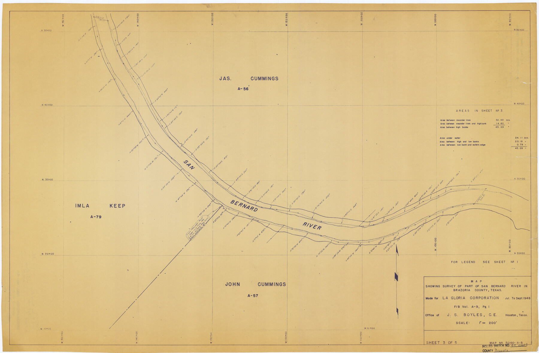
Brazoria County Rolled Sketch 49
Map showing survey of part of San Bernard River in Brazoria County, Texas - Sheet 3 of 5
Miscellaneous Roll No. 4
-
Map/Doc
5184
-
Collection
General Map Collection
-
Object Dates
1948 (Creation Date)
1976/2/12 (File Date)
-
People and Organizations
J.S. Boyles (Surveyor/Engineer)
-
Counties
Brazoria
-
Subjects
Surveying Rolled Sketch
-
Height x Width
23.8 x 36.2 inches
60.5 x 91.9 cm
-
Medium
blueprint/diazo
-
Scale
1" = 200'
-
Comments
See 5182, 5183, 5185, and 5186 for other sheets and Brazoria County Sketch File 43 (15059) for report.
Related maps
Brazoria County Sketch File 43

Print $18.00
- Digital $50.00
Brazoria County Sketch File 43
1949
Size 14.5 x 9.0 inches
Map/Doc 15059
Brazoria County Rolled Sketch 49

Print $20.00
- Digital $50.00
Brazoria County Rolled Sketch 49
1948
Size 23.8 x 36.1 inches
Map/Doc 5182
Brazoria County Rolled Sketch 49

Print $20.00
- Digital $50.00
Brazoria County Rolled Sketch 49
1948
Size 23.7 x 36.3 inches
Map/Doc 5183
Brazoria County Rolled Sketch 49

Print $20.00
- Digital $50.00
Brazoria County Rolled Sketch 49
1948
Size 23.8 x 36.0 inches
Map/Doc 5185
Brazoria County Rolled Sketch 49

Print $20.00
- Digital $50.00
Brazoria County Rolled Sketch 49
1948
Size 24.1 x 36.5 inches
Map/Doc 5186
Part of: General Map Collection
Edwards County Working Sketch 133

Print $20.00
- Digital $50.00
Edwards County Working Sketch 133
1985
Size 29.7 x 38.9 inches
Map/Doc 69009
Lamar County State Real Property Sketch 1

Print $40.00
- Digital $50.00
Lamar County State Real Property Sketch 1
2013
Size 48.0 x 36.0 inches
Map/Doc 93662
Flight Mission No. DIX-10P, Frame 146, Aransas County

Print $20.00
- Digital $50.00
Flight Mission No. DIX-10P, Frame 146, Aransas County
1956
Size 18.6 x 22.4 inches
Map/Doc 83948
Township No. 4 South Range No. 14 West of the Indian Meridian

Print $4.00
- Digital $50.00
Township No. 4 South Range No. 14 West of the Indian Meridian
1875
Size 18.0 x 22.4 inches
Map/Doc 75144
Northern Part of Laguna Madre

Print $20.00
- Digital $50.00
Northern Part of Laguna Madre
1946
Size 43.8 x 34.5 inches
Map/Doc 73523
State of Texas, Plate 1: Surface-Water Development, Exisiting Reservoirs and Reservoir Sites

Print $20.00
- Digital $50.00
State of Texas, Plate 1: Surface-Water Development, Exisiting Reservoirs and Reservoir Sites
1984
Size 17.8 x 18.1 inches
Map/Doc 3128
Aransas County Sketch File 5

Print $4.00
- Digital $50.00
Aransas County Sketch File 5
1850
Size 12.1 x 7.9 inches
Map/Doc 13108
Cameron County Sketch File 14

Print $38.00
- Digital $50.00
Cameron County Sketch File 14
1993
Size 11.2 x 8.8 inches
Map/Doc 17311
La Salle County Rolled Sketch 26

Print $20.00
- Digital $50.00
La Salle County Rolled Sketch 26
1969
Size 23.6 x 24.7 inches
Map/Doc 6587
Sherman County Boundary File 2

Print $34.00
- Digital $50.00
Sherman County Boundary File 2
Size 13.0 x 9.0 inches
Map/Doc 58761
[Surveys in Polk and Tyler Counties, Liberty District]
![354, [Surveys in Polk and Tyler Counties, Liberty District], General Map Collection](https://historictexasmaps.com/wmedia_w700/maps/354.tif.jpg)
Print $2.00
- Digital $50.00
[Surveys in Polk and Tyler Counties, Liberty District]
1847
Size 10.8 x 8.1 inches
Map/Doc 354
[Map showing resurvey of Capitol Leagues in Hartley & Dallam Counties, Texas]
![1753, [Map showing resurvey of Capitol Leagues in Hartley & Dallam Counties, Texas], General Map Collection](https://historictexasmaps.com/wmedia_w700/maps/1753-1.tif.jpg)
Print $40.00
- Digital $50.00
[Map showing resurvey of Capitol Leagues in Hartley & Dallam Counties, Texas]
1918
Size 66.9 x 31.0 inches
Map/Doc 1753
You may also like
Marion County Rolled Sketch 4

Print $40.00
- Digital $50.00
Marion County Rolled Sketch 4
1951
Size 43.1 x 58.0 inches
Map/Doc 9491
Polk County Working Sketch 17

Print $20.00
- Digital $50.00
Polk County Working Sketch 17
1948
Size 28.3 x 18.5 inches
Map/Doc 71632
Hudspeth County Working Sketch 19

Print $20.00
- Digital $50.00
Hudspeth County Working Sketch 19
1959
Size 21.5 x 24.3 inches
Map/Doc 66301
[Sketch for Mineral Application 33721 - 33725 Incl. - Padre and Mustang Island]
![2870, [Sketch for Mineral Application 33721 - 33725 Incl. - Padre and Mustang Island], General Map Collection](https://historictexasmaps.com/wmedia_w700/maps/2870.tif.jpg)
Print $20.00
- Digital $50.00
[Sketch for Mineral Application 33721 - 33725 Incl. - Padre and Mustang Island]
1942
Size 22.1 x 22.4 inches
Map/Doc 2870
Reagan County Rolled Sketch 9

Print $20.00
- Digital $50.00
Reagan County Rolled Sketch 9
1937
Size 29.7 x 30.9 inches
Map/Doc 7437
Jasper County Texas

Print $20.00
- Digital $50.00
Jasper County Texas
1879
Size 31.5 x 18.2 inches
Map/Doc 3716
Flight Mission No. BRA-8M, Frame 133, Jefferson County

Print $20.00
- Digital $50.00
Flight Mission No. BRA-8M, Frame 133, Jefferson County
1953
Size 18.7 x 22.3 inches
Map/Doc 85629
Texas City Channel, Texas, Channel and Turning Basin Dredging - Sheet 4

Print $20.00
- Digital $50.00
Texas City Channel, Texas, Channel and Turning Basin Dredging - Sheet 4
1958
Size 28.5 x 40.9 inches
Map/Doc 61834
Mills County Sketch File 6

Print $4.00
- Digital $50.00
Mills County Sketch File 6
Size 9.0 x 9.8 inches
Map/Doc 31655
Fort Bend County Sketch File 20

Print $2.00
- Digital $50.00
Fort Bend County Sketch File 20
Size 8.9 x 9.4 inches
Map/Doc 22953
Presidio County Sketch File 33

Print $16.00
- Digital $50.00
Presidio County Sketch File 33
1890
Size 14.5 x 8.8 inches
Map/Doc 34476
Martin County Rolled Sketch 6

Print $20.00
- Digital $50.00
Martin County Rolled Sketch 6
Size 25.8 x 26.9 inches
Map/Doc 6666