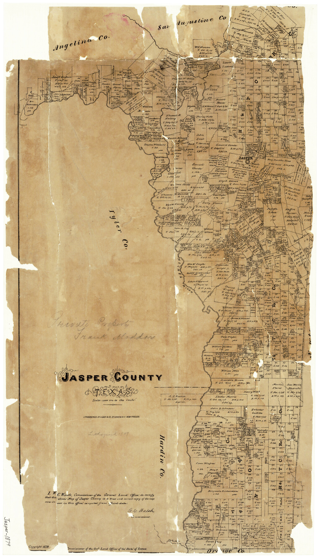
Jasper County Texas
-
Map/Doc
3716
-
Collection
General Map Collection
-
Object Dates
1879 (Creation Date)
-
People and Organizations
W.C. Walsh (GLO Commissioner)
August Gast & Co. (Lithographer)
-
Counties
Jasper
-
Subjects
County
-
Height x Width
31.5 x 18.2 inches
80.0 x 46.2 cm
-
Comments
Copyrighted 1879.
-
Features
Spring Creek
Big Sandy Creek
10 Mile Creek
Cow Bayou
Mill Creek
Boggy Creek
Trout Creek
Everett Creek
Neches River
Wright Creek
Big Creek
Robinson Branch [of Neches River]
South Branch [of Everett Creek]
Walnut Run
Sandy Creek
Bear Creek
Indian Creek
Prairie Creek
Walnut Creek
Bevil
Jasper
4 Miles Branch
Beef Creek
Hog Creek
Williams Branch [of Indian Creek]
Jordan Branch [of Indian Creek]
7 Mile Creek
Angelina River
Tiger Creek
Ayish Bayou
Part of: General Map Collection

Stonewall County Sketch File B1

Print $20.00
- Digital $50.00
Stonewall County Sketch File B1
1901
Size 36.2 x 34.9 inches
Map/Doc 10379
Coke County Working Sketch 16

Print $20.00
- Digital $50.00
Coke County Working Sketch 16
1948
Size 23.4 x 24.5 inches
Map/Doc 68053
Matagorda County Working Sketch 32

Print $20.00
- Digital $50.00
Matagorda County Working Sketch 32
1993
Size 28.4 x 33.5 inches
Map/Doc 70890
Clay County Sketch File 20

Print $8.00
- Digital $50.00
Clay County Sketch File 20
1882
Size 11.2 x 8.6 inches
Map/Doc 18431
Pecos County Working Sketch 14

Print $20.00
- Digital $50.00
Pecos County Working Sketch 14
1912
Size 16.7 x 13.5 inches
Map/Doc 71484
Travis County Working Sketch 46

Print $20.00
- Digital $50.00
Travis County Working Sketch 46
1981
Size 46.6 x 36.9 inches
Map/Doc 69430
![94190, California [Recto], General Map Collection](https://historictexasmaps.com/wmedia_w700/maps/94190.tif.jpg)
Wilbarger County Working Sketch 19

Print $20.00
- Digital $50.00
Wilbarger County Working Sketch 19
1972
Size 36.6 x 38.3 inches
Map/Doc 72557
Leon County Rolled Sketch 24

Print $20.00
- Digital $50.00
Leon County Rolled Sketch 24
1986
Size 34.7 x 39.6 inches
Map/Doc 6610
Map of Nacogdoches County

Print $20.00
- Digital $50.00
Map of Nacogdoches County
1881
Size 24.5 x 21.5 inches
Map/Doc 4600
Drainage Basins of Texas Streams

Print $20.00
- Digital $50.00
Drainage Basins of Texas Streams
Size 35.3 x 42.0 inches
Map/Doc 65270
You may also like
W. D. Twichell's and R. S. Hunnicutt's Resurvey in Oldham County, Texas May to October, 1916

Print $40.00
- Digital $50.00
W. D. Twichell's and R. S. Hunnicutt's Resurvey in Oldham County, Texas May to October, 1916
1915
Size 48.0 x 39.0 inches
Map/Doc 89975
East Portion of Matagorda Bay in Matagorda County, showing Subdivision for Mineral Development

Print $40.00
- Digital $50.00
East Portion of Matagorda Bay in Matagorda County, showing Subdivision for Mineral Development
1949
Size 30.8 x 51.1 inches
Map/Doc 1909
Ward County Working Sketch 32

Print $40.00
- Digital $50.00
Ward County Working Sketch 32
1967
Size 32.5 x 66.0 inches
Map/Doc 72338
Hudspeth County Working Sketch 35

Print $40.00
- Digital $50.00
Hudspeth County Working Sketch 35
Size 37.0 x 55.2 inches
Map/Doc 66320
Morris County Rolled Sketch 2A

Print $20.00
- Digital $50.00
Morris County Rolled Sketch 2A
Size 24.0 x 18.7 inches
Map/Doc 10280
Reeves County Rolled Sketch 14A

Print $20.00
- Digital $50.00
Reeves County Rolled Sketch 14A
1948
Size 26.0 x 18.9 inches
Map/Doc 7483
Liberty County Sketch File 27a

Print $4.00
- Digital $50.00
Liberty County Sketch File 27a
1870
Size 11.6 x 9.0 inches
Map/Doc 29950
[North Part of Block G]
![92637, [North Part of Block G], Twichell Survey Records](https://historictexasmaps.com/wmedia_w700/maps/92637-1.tif.jpg)
Print $20.00
- Digital $50.00
[North Part of Block G]
Size 24.1 x 19.7 inches
Map/Doc 92637
Palo Pinto County Sketch File 28

Print $8.00
- Digital $50.00
Palo Pinto County Sketch File 28
1875
Size 11.3 x 8.6 inches
Map/Doc 33437
Floyd County Boundary File 2b

Print $40.00
- Digital $50.00
Floyd County Boundary File 2b
Size 38.9 x 20.1 inches
Map/Doc 53490
Garza County Sketch File 31

Print $10.00
- Digital $50.00
Garza County Sketch File 31
1914
Size 13.4 x 8.9 inches
Map/Doc 24104
Armstrong County

Print $20.00
- Digital $50.00
Armstrong County
1933
Size 42.3 x 41.0 inches
Map/Doc 73071