Garza County Sketch File 31
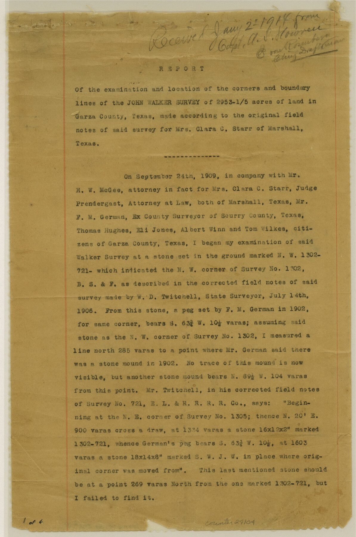
[Report of the examination and location of the corners and boundary lines of the John Walker survey]
Garza County Rolled Sketch P
-
Map/Doc
24104
-
Collection
General Map Collection
-
Object Dates
1914/1/2 (File Date)
1906/7/14 (Survey Date)
1902 (Survey Date)
1878 (Survey Date)
1914 (Creation Date)
-
People and Organizations
A.S. Howren (Surveyor/Engineer)
F.M. German (Surveyor/Engineer)
W.D. Twichell (Surveyor/Engineer)
-
Counties
Garza
-
Subjects
Surveying Sketch File
-
Height x Width
13.4 x 8.9 inches
34.0 x 22.6 cm
-
Medium
paper, print
-
Comments
See Garza County Rolled Sketch P (6005) for sketch.
-
Features
Yellow House River
Related maps
Garza County Rolled Sketch P

Print $20.00
- Digital $50.00
Garza County Rolled Sketch P
1914
Size 21.3 x 23.3 inches
Map/Doc 6005
Part of: General Map Collection
Fannin County

Print $20.00
- Digital $50.00
Fannin County
1946
Size 40.6 x 35.4 inches
Map/Doc 77277
Denton County Working Sketch 1

Print $20.00
- Digital $50.00
Denton County Working Sketch 1
1920
Size 16.1 x 12.9 inches
Map/Doc 68606
Township 4 South Ranges 12 and 13 West, South Western District, Louisiana

Print $2.00
- Digital $50.00
Township 4 South Ranges 12 and 13 West, South Western District, Louisiana
1968
Size 10.5 x 7.6 inches
Map/Doc 65889
[Gulf, Colorado & Santa Fe Railway Company]
![64410, [Gulf, Colorado & Santa Fe Railway Company], General Map Collection](https://historictexasmaps.com/wmedia_w700/maps/64410.tif.jpg)
Print $40.00
- Digital $50.00
[Gulf, Colorado & Santa Fe Railway Company]
1893
Size 21.5 x 121.2 inches
Map/Doc 64410

Orange County Sketch File 27

Print $20.00
- Digital $50.00
Orange County Sketch File 27
1915
Size 18.6 x 21.8 inches
Map/Doc 12123
Galveston County Sketch File 46

Print $20.00
- Digital $50.00
Galveston County Sketch File 46
1912
Size 14.0 x 34.1 inches
Map/Doc 11541
Supreme Court of the United States, October Term, 1924, No. 13, Original - The State of Oklahoma, Complainant vs. The State of Texas, Defendant, The United States, Intervener

Print $20.00
- Digital $50.00
Supreme Court of the United States, October Term, 1924, No. 13, Original - The State of Oklahoma, Complainant vs. The State of Texas, Defendant, The United States, Intervener
1924
Size 26.5 x 38.5 inches
Map/Doc 75131
Survey of the Mexican Lines of Defence at Cerro Gordo, and the lines of attack of the American Army under Major General Scott, on the 17th and 18th of April, 1847

Print $20.00
- Digital $50.00
Survey of the Mexican Lines of Defence at Cerro Gordo, and the lines of attack of the American Army under Major General Scott, on the 17th and 18th of April, 1847
1847
Size 15.3 x 21.6 inches
Map/Doc 95830
Orange County Working Sketch 40

Print $20.00
- Digital $50.00
Orange County Working Sketch 40
1979
Size 19.2 x 12.1 inches
Map/Doc 71372
Throckmorton County Rolled Sketch 6B

Print $20.00
- Digital $50.00
Throckmorton County Rolled Sketch 6B
2004
Size 20.3 x 24.2 inches
Map/Doc 82490
Harris County Working Sketch 7

Print $20.00
- Digital $50.00
Harris County Working Sketch 7
1900
Size 34.2 x 28.6 inches
Map/Doc 65899
You may also like
Presidio County Sketch File 40

Print $20.00
- Digital $50.00
Presidio County Sketch File 40
1912
Size 24.7 x 23.4 inches
Map/Doc 11715
Topographical Map of the Rio Grande, Sheet No. 5

Print $20.00
- Digital $50.00
Topographical Map of the Rio Grande, Sheet No. 5
1912
Map/Doc 89529
Flight Mission No. BQY-4M, Frame 39, Harris County

Print $20.00
- Digital $50.00
Flight Mission No. BQY-4M, Frame 39, Harris County
1953
Size 18.6 x 22.3 inches
Map/Doc 85254
Culberson County

Print $40.00
- Digital $50.00
Culberson County
1924
Size 32.4 x 48.5 inches
Map/Doc 92559
Tom Green County Boundary File 87b

Print $4.00
- Digital $50.00
Tom Green County Boundary File 87b
Size 13.0 x 8.6 inches
Map/Doc 59401
Old Miscellaneous File 39

Print $10.00
- Digital $50.00
Old Miscellaneous File 39
1893
Size 14.2 x 8.8 inches
Map/Doc 75284
Map of Galveston, Turtle & East Bays & portions of the Gulf of Mexico in Chambers & Galveston Counties, Texas showing subdivision for mineral development

Print $40.00
- Digital $50.00
Map of Galveston, Turtle & East Bays & portions of the Gulf of Mexico in Chambers & Galveston Counties, Texas showing subdivision for mineral development
1945
Size 46.3 x 52.8 inches
Map/Doc 3068
Hockley County Working Sketch Graphic Index

Print $20.00
- Digital $50.00
Hockley County Working Sketch Graphic Index
1954
Size 42.3 x 37.8 inches
Map/Doc 76579
Colorado County Sketch File 13

Print $4.00
- Digital $50.00
Colorado County Sketch File 13
Size 12.5 x 8.3 inches
Map/Doc 18937
Crockett County Sketch File F

Print $20.00
- Digital $50.00
Crockett County Sketch File F
1907
Size 26.3 x 15.7 inches
Map/Doc 11240
Nueces County Sketch File 53

Print $4.00
- Digital $50.00
Nueces County Sketch File 53
1903
Size 11.1 x 8.8 inches
Map/Doc 32863
Tahoka Consolidated Independent School District

Print $20.00
- Digital $50.00
Tahoka Consolidated Independent School District
Size 34.1 x 22.1 inches
Map/Doc 92943