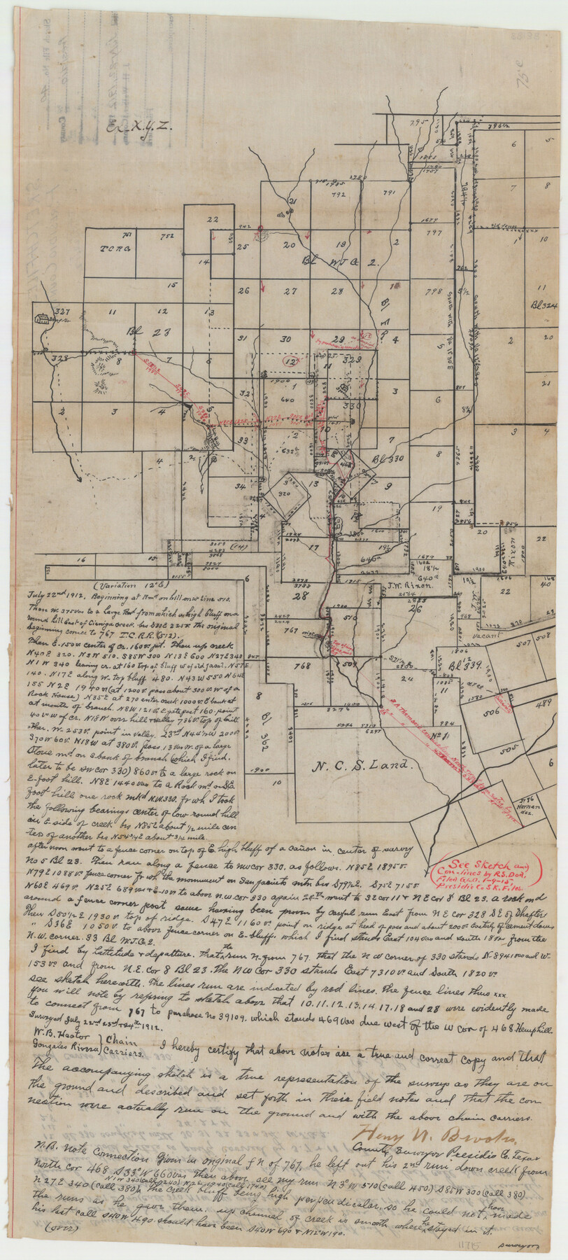
Presidio County Sketch File 40
[Sketches and field notes showing Block 330 & surrounding blocks in Presidio County, Texas]
-
Map/Doc
11715
-
Collection
General Map Collection
-
Object Dates
7/1912 (Creation Date)
7/22/1912 (File Date)
7/22/1912 (Survey Date)
-
People and Organizations
Morris (Draftsman)
Henry W. Brooks (Surveyor/Engineer)
W.B. Hector (Chainman/Field Personnel)
Gonzales Rivera (Chainman/Field Personnel)
-
Counties
Presidio
-
Subjects
Surveying Sketch File
-
Height x Width
24.7 x 23.4 inches
62.7 x 59.4 cm
-
Medium
multi-page, multi-format
-
Features
Shafter House
Cieniga [sic] Creek
San Jacinto [Peak]
Part of: General Map Collection
Preliminary Chart No. 31 of the Sea Coast of the United States from Galveston Bay to Matagorda Bay, Texas

Print $20.00
- Digital $50.00
Preliminary Chart No. 31 of the Sea Coast of the United States from Galveston Bay to Matagorda Bay, Texas
1857
Size 22.7 x 38.7 inches
Map/Doc 69949
Tom Green County Working Sketch 13

Print $20.00
- Digital $50.00
Tom Green County Working Sketch 13
1981
Size 34.3 x 26.4 inches
Map/Doc 69382
Flight Mission No. DQO-2K, Frame 141, Galveston County

Print $20.00
- Digital $50.00
Flight Mission No. DQO-2K, Frame 141, Galveston County
1952
Size 18.9 x 22.5 inches
Map/Doc 85038
Kaufman County Working Sketch 7

Print $20.00
- Digital $50.00
Kaufman County Working Sketch 7
1984
Size 33.6 x 35.5 inches
Map/Doc 66670
New Map of Greater San Antonio

Print $20.00
- Digital $50.00
New Map of Greater San Antonio
1941
Size 24.5 x 19.7 inches
Map/Doc 95954
Potter County Boundary File 5

Print $24.00
- Digital $50.00
Potter County Boundary File 5
Size 15.0 x 9.4 inches
Map/Doc 58013
Controlled Mosaic by Jack Amman Photogrammetric Engineers, Inc - Sheet 24

Print $20.00
- Digital $50.00
Controlled Mosaic by Jack Amman Photogrammetric Engineers, Inc - Sheet 24
1954
Size 20.0 x 24.0 inches
Map/Doc 83475
A Map of the Cotton Kingdom and its Dependencies in America

Print $20.00
- Digital $50.00
A Map of the Cotton Kingdom and its Dependencies in America
1861
Size 12.2 x 18.6 inches
Map/Doc 96573
Padre Island National Seashore, Texas - Dependent Resurvey

Print $4.00
- Digital $50.00
Padre Island National Seashore, Texas - Dependent Resurvey
2001
Size 17.8 x 24.2 inches
Map/Doc 60544
Dawson County Sketch File 20

Print $20.00
- Digital $50.00
Dawson County Sketch File 20
1951
Size 13.2 x 21.5 inches
Map/Doc 11296
Concho County Sketch File 8

Print $44.00
- Digital $50.00
Concho County Sketch File 8
1886
Size 16.2 x 12.2 inches
Map/Doc 19131
Jones County Rolled Sketch 1

Print $20.00
- Digital $50.00
Jones County Rolled Sketch 1
1957
Size 26.1 x 28.3 inches
Map/Doc 6450
You may also like
Map of Hays County, Texas

Print $20.00
- Digital $50.00
Map of Hays County, Texas
1880
Size 24.3 x 21.4 inches
Map/Doc 5029
Travis County Sketch File 30

Print $6.00
- Digital $50.00
Travis County Sketch File 30
1884
Size 17.0 x 11.0 inches
Map/Doc 38343
'O Bar O' Ranch

Print $40.00
- Digital $50.00
'O Bar O' Ranch
1946
Size 47.8 x 82.6 inches
Map/Doc 93202
Floyd County Sketch File 11

Print $2.00
- Digital $50.00
Floyd County Sketch File 11
1914
Size 3.8 x 6.7 inches
Map/Doc 22707
Flight Mission No. DAG-21K, Frame 119, Matagorda County

Print $20.00
- Digital $50.00
Flight Mission No. DAG-21K, Frame 119, Matagorda County
1952
Size 18.6 x 22.5 inches
Map/Doc 86445
Palo Pinto County Working Sketch Graphic Index

Print $20.00
- Digital $50.00
Palo Pinto County Working Sketch Graphic Index
1941
Map/Doc 76659

Upton County Working Sketch 34

Print $40.00
- Digital $50.00
Upton County Working Sketch 34
1956
Size 29.6 x 49.1 inches
Map/Doc 69530
Stephens County Boundary File 81

Print $44.00
- Digital $50.00
Stephens County Boundary File 81
Size 9.2 x 3.8 inches
Map/Doc 58906
Goliad County Sketch File 28

Print $20.00
- Digital $50.00
Goliad County Sketch File 28
Size 18.9 x 15.5 inches
Map/Doc 11569
Starr County Rolled Sketch 11

Print $20.00
- Digital $50.00
Starr County Rolled Sketch 11
1912
Size 16.5 x 16.4 inches
Map/Doc 7798
Webb County Rolled Sketch 46

Print $20.00
- Digital $50.00
Webb County Rolled Sketch 46
1942
Size 28.2 x 26.9 inches
Map/Doc 8201