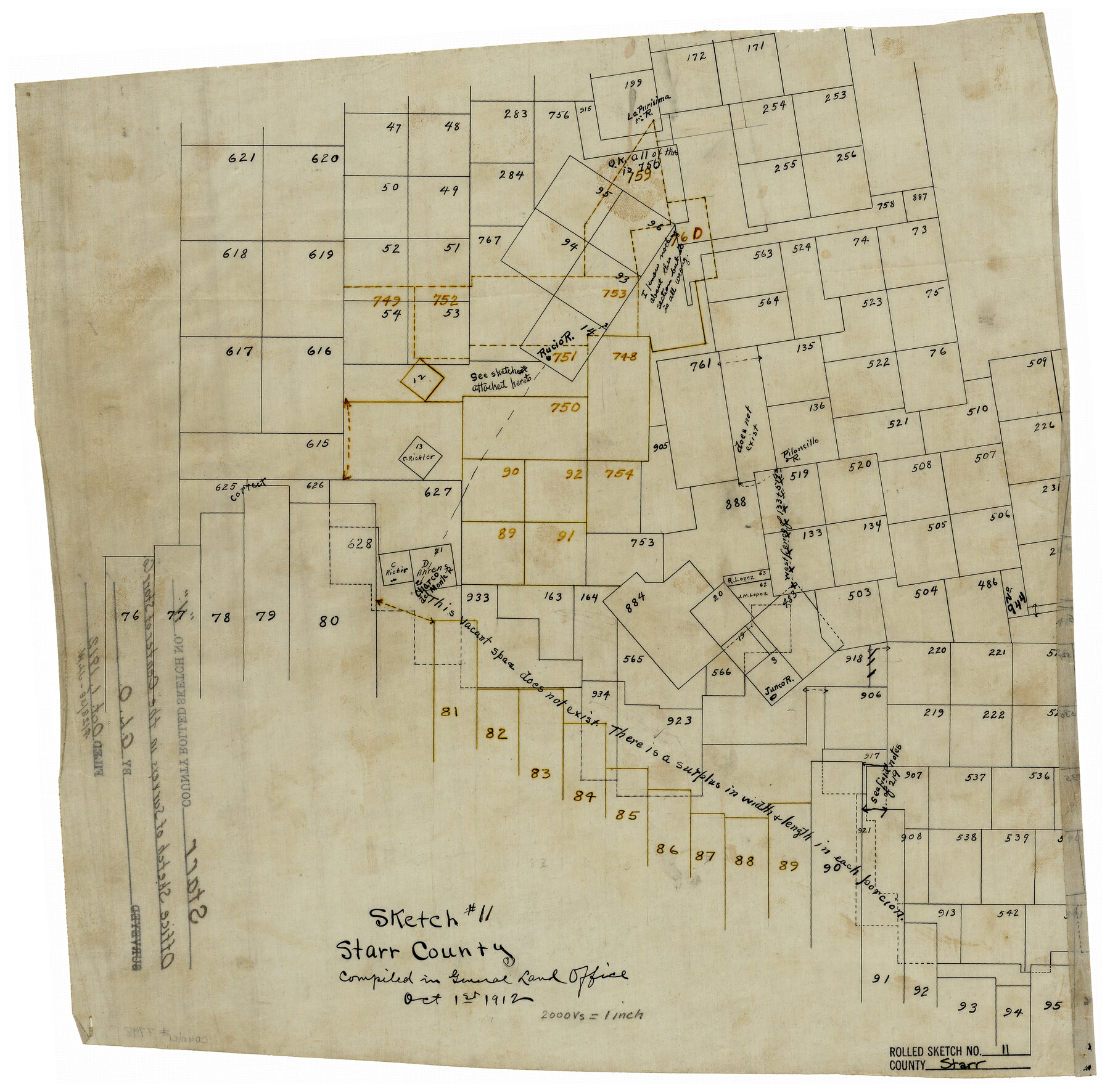
Starr County Rolled Sketch 11
[Office sketch of area around survey 751]
-
Map/Doc
7798
-
Collection
General Map Collection
-
Object Dates
10/1/1912 (Creation Date)
-
Counties
Starr
-
Subjects
Surveying Rolled Sketch
-
Height x Width
16.5 x 16.4 inches
41.9 x 41.7 cm
-
Medium
linen, manuscript
-
Scale
1" = 2000 varas
Part of: General Map Collection
Dimmit County Sketch File 50

Print $36.00
- Digital $50.00
Dimmit County Sketch File 50
1909
Size 18.2 x 20.4 inches
Map/Doc 21181
Right of Way & Track Map, St. Louis, Brownsville & Mexico Ry. operated by St. Louis, Brownsville & Mexico Ry. Co.

Print $40.00
- Digital $50.00
Right of Way & Track Map, St. Louis, Brownsville & Mexico Ry. operated by St. Louis, Brownsville & Mexico Ry. Co.
1919
Size 25.7 x 57.1 inches
Map/Doc 64625
McLennan County Boundary File 1a

Print $14.00
- Digital $50.00
McLennan County Boundary File 1a
Size 8.0 x 6.6 inches
Map/Doc 56941
Kinney County Rolled Sketch 2

Print $20.00
- Digital $50.00
Kinney County Rolled Sketch 2
Size 24.5 x 36.2 inches
Map/Doc 6534
Menard County Boundary File 13a

Print $6.00
- Digital $50.00
Menard County Boundary File 13a
Size 11.2 x 8.7 inches
Map/Doc 57137
Flight Mission No. BRA-7M, Frame 182, Jefferson County

Print $20.00
- Digital $50.00
Flight Mission No. BRA-7M, Frame 182, Jefferson County
1953
Size 18.5 x 22.3 inches
Map/Doc 85550
Ward County Rolled Sketch 15

Print $20.00
- Digital $50.00
Ward County Rolled Sketch 15
1941
Size 26.9 x 39.2 inches
Map/Doc 8158
Brewster County Rolled Sketch 123

Print $25.00
- Digital $50.00
Brewster County Rolled Sketch 123
Size 10.1 x 15.3 inches
Map/Doc 43129
Parker County Working Sketch 10

Print $20.00
- Digital $50.00
Parker County Working Sketch 10
1969
Map/Doc 71460
Texas Intracoastal Waterway - Port O'Connor to San Antonio Bay, Including Pass Cavallo

Print $20.00
- Digital $50.00
Texas Intracoastal Waterway - Port O'Connor to San Antonio Bay, Including Pass Cavallo
1961
Size 26.5 x 38.7 inches
Map/Doc 73373
[Sabine Pass]
![73343, [Sabine Pass], General Map Collection](https://historictexasmaps.com/wmedia_w700/maps/73343.tif.jpg)
Print $20.00
- Digital $50.00
[Sabine Pass]
1916
Size 18.5 x 26.5 inches
Map/Doc 73343
Pecos County Rolled Sketch 25B

Print $20.00
- Digital $50.00
Pecos County Rolled Sketch 25B
1892
Size 22.2 x 16.0 inches
Map/Doc 7210
You may also like
Jasper County Sketch File 24

Print $4.00
- Digital $50.00
Jasper County Sketch File 24
1925
Size 10.9 x 8.3 inches
Map/Doc 27824
Ward County Working Sketch 26

Print $20.00
- Digital $50.00
Ward County Working Sketch 26
1964
Size 38.2 x 24.5 inches
Map/Doc 72332
Hudspeth County Sketch File 31

Print $20.00
- Digital $50.00
Hudspeth County Sketch File 31
1908
Size 18.7 x 17.7 inches
Map/Doc 11805
Crane County Working Sketch 22

Print $20.00
- Digital $50.00
Crane County Working Sketch 22
1961
Size 44.7 x 43.9 inches
Map/Doc 68299
Calhoun County Sketch File 13

Print $36.00
- Digital $50.00
Calhoun County Sketch File 13
1940
Size 14.3 x 8.3 inches
Map/Doc 35962
Irion County Working Sketch 9

Print $20.00
- Digital $50.00
Irion County Working Sketch 9
1941
Size 13.6 x 17.2 inches
Map/Doc 66418
[Surveys along the Sabine River made under G.W. Smyth, Commissioner]
![90, [Surveys along the Sabine River made under G.W. Smyth, Commissioner], General Map Collection](https://historictexasmaps.com/wmedia_w700/maps/90.tif.jpg)
Print $20.00
- Digital $50.00
[Surveys along the Sabine River made under G.W. Smyth, Commissioner]
1837
Size 13.9 x 17.0 inches
Map/Doc 90
Flight Mission No. DQN-1K, Frame 34, Calhoun County

Print $20.00
- Digital $50.00
Flight Mission No. DQN-1K, Frame 34, Calhoun County
1953
Size 18.5 x 22.2 inches
Map/Doc 84139
Flight Mission No. DAG-23K, Frame 187, Matagorda County

Print $20.00
- Digital $50.00
Flight Mission No. DAG-23K, Frame 187, Matagorda County
1953
Size 17.5 x 22.4 inches
Map/Doc 86522

Hardeman County Boundary File 4

Print $142.00
- Digital $50.00
Hardeman County Boundary File 4
Size 24.0 x 18.2 inches
Map/Doc 54392
Calhoun County Rolled Sketch 12

Print $40.00
- Digital $50.00
Calhoun County Rolled Sketch 12
1940
Size 30.2 x 54.8 inches
Map/Doc 43619