Webb County Rolled Sketch 46
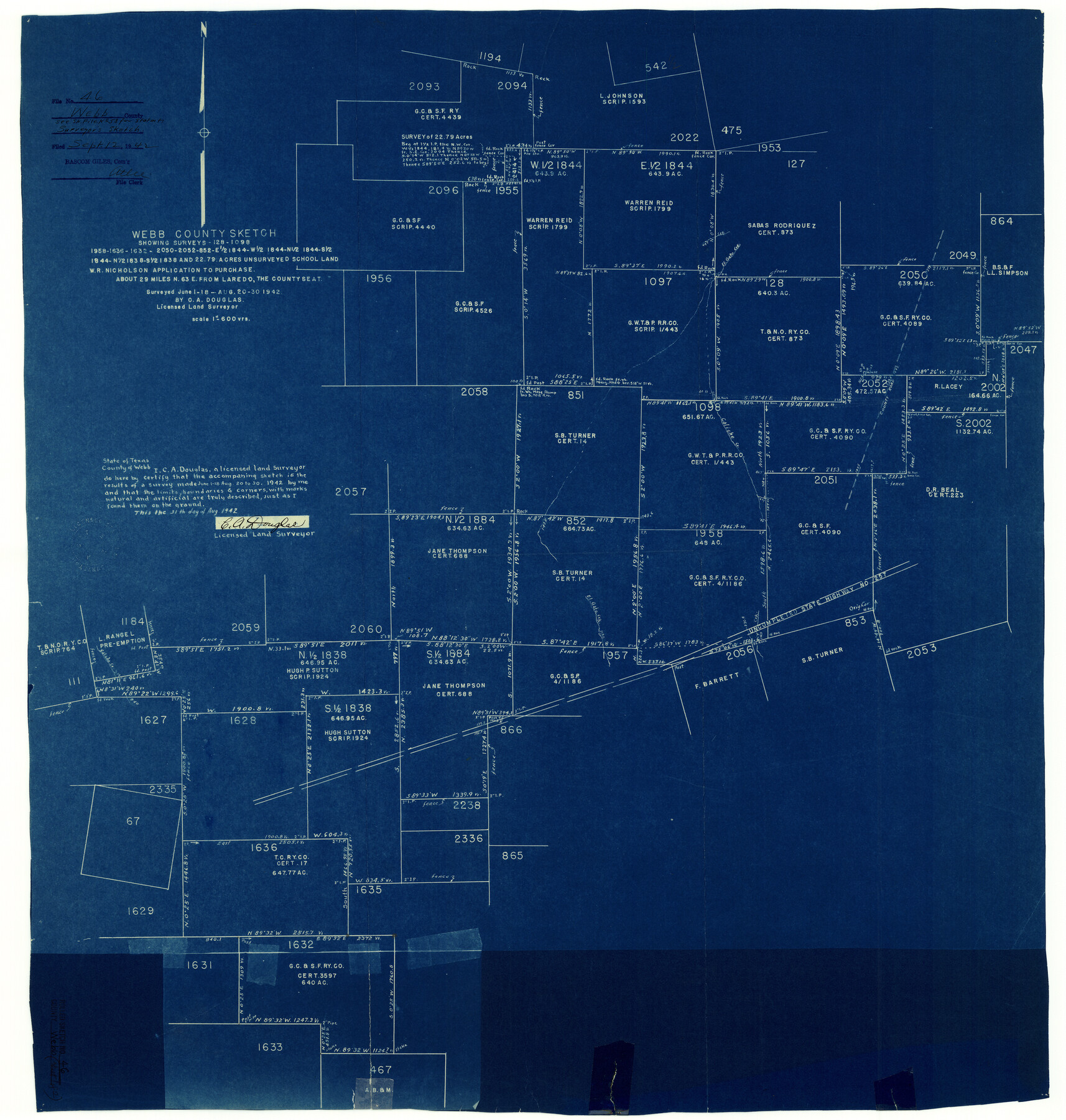
Webb County sketch showing surveys 128, 1098, 1958, 1636, 1632, 2050, 2052, 852, E 1/2 1844, W 1/2 1844, N 1/2 1844, S 1/2 1844, N 1/2 1838, S 1/2 1838, and 22.79 acres unsurveyed School Land
-
Map/Doc
8201
-
Collection
General Map Collection
-
Object Dates
1942/8/30 (Survey Date)
1942/9/12 (File Date)
1942/8/31 (Creation Date)
-
People and Organizations
C.A. Douglas (Surveyor/Engineer)
-
Counties
Webb
-
Subjects
Surveying Rolled Sketch
-
Height x Width
28.2 x 26.9 inches
71.6 x 68.3 cm
-
Medium
blueprint/diazo
-
Scale
1" = 600 varas
Related maps
Webb County Sketch File 58

Print $10.00
- Digital $50.00
Webb County Sketch File 58
1942
Size 14.4 x 8.9 inches
Map/Doc 39846
Part of: General Map Collection
Pecos County Rolled Sketch 118

Print $20.00
- Digital $50.00
Pecos County Rolled Sketch 118
1941
Size 42.0 x 30.3 inches
Map/Doc 7260
McMullen County Working Sketch 53

Print $20.00
- Digital $50.00
McMullen County Working Sketch 53
1983
Size 18.1 x 18.7 inches
Map/Doc 70754
Map of Baylor County

Print $20.00
- Digital $50.00
Map of Baylor County
1895
Size 47.4 x 37.0 inches
Map/Doc 4882
Flight Mission No. BQY-15M, Frame 11, Harris County

Print $20.00
- Digital $50.00
Flight Mission No. BQY-15M, Frame 11, Harris County
1953
Size 18.5 x 22.4 inches
Map/Doc 85309
Archer County Sketch File 21

Print $40.00
- Digital $50.00
Archer County Sketch File 21
Size 30.3 x 19.8 inches
Map/Doc 10830
Bandera County Working Sketch 58

Print $20.00
- Digital $50.00
Bandera County Working Sketch 58
2001
Size 34.9 x 36.7 inches
Map/Doc 67654
Brazoria County Sketch File 57

Print $10.00
- Digital $50.00
Brazoria County Sketch File 57
1940
Size 8.7 x 6.3 inches
Map/Doc 15377
Morris County Rolled Sketch 2A

Print $20.00
- Digital $50.00
Morris County Rolled Sketch 2A
Size 24.3 x 19.2 inches
Map/Doc 10255
Flight Mission No. CGI-4N, Frame 30, Cameron County

Print $20.00
- Digital $50.00
Flight Mission No. CGI-4N, Frame 30, Cameron County
1954
Size 18.6 x 22.3 inches
Map/Doc 84663
Hale County Rolled Sketch 5

Print $20.00
- Digital $50.00
Hale County Rolled Sketch 5
1893
Size 29.0 x 22.2 inches
Map/Doc 9094
Plat showing proposed counties to be taken from Zapata, Starr & Hidalgo Counties

Print $20.00
- Digital $50.00
Plat showing proposed counties to be taken from Zapata, Starr & Hidalgo Counties
1911
Size 24.8 x 27.0 inches
Map/Doc 2478
Aransas County NRC Article 33.136 Sketch 3

Print $20.00
- Digital $50.00
Aransas County NRC Article 33.136 Sketch 3
2003
Size 25.1 x 36.1 inches
Map/Doc 80138
You may also like
[Leagues 7, 8, 9, and 10]
![92219, [Leagues 7, 8, 9, and 10], Twichell Survey Records](https://historictexasmaps.com/wmedia_w700/maps/92219-1.tif.jpg)
Print $20.00
- Digital $50.00
[Leagues 7, 8, 9, and 10]
1943
Size 20.6 x 12.5 inches
Map/Doc 92219
Atascosa County Working Sketch 36

Print $20.00
- Digital $50.00
Atascosa County Working Sketch 36
2008
Size 29.4 x 44.5 inches
Map/Doc 88878
Outer Continental Shelf Leasing Maps (Louisiana Offshore Operations)

Print $20.00
- Digital $50.00
Outer Continental Shelf Leasing Maps (Louisiana Offshore Operations)
1959
Size 21.4 x 13.9 inches
Map/Doc 76099
Webb County Sketch File D

Print $6.00
- Digital $50.00
Webb County Sketch File D
1876
Size 14.4 x 9.0 inches
Map/Doc 39678
Frio County Rolled Sketch 6

Print $20.00
- Digital $50.00
Frio County Rolled Sketch 6
1938
Size 42.7 x 32.6 inches
Map/Doc 76019
Outer Continental Shelf Leasing Maps (Louisiana Offshore Operations)

Print $20.00
- Digital $50.00
Outer Continental Shelf Leasing Maps (Louisiana Offshore Operations)
1959
Size 18.0 x 14.0 inches
Map/Doc 76118
Morris County Rolled Sketch 2A

Print $20.00
- Digital $50.00
Morris County Rolled Sketch 2A
Size 24.0 x 18.7 inches
Map/Doc 10234
Fort Bend County Sketch File 26

Print $46.00
- Digital $50.00
Fort Bend County Sketch File 26
Size 8.9 x 9.1 inches
Map/Doc 22956
Amistad International Reservoir on Rio Grande 70a

Print $20.00
- Digital $50.00
Amistad International Reservoir on Rio Grande 70a
1949
Size 28.5 x 39.5 inches
Map/Doc 73357
Parker County Sketch File 12

Print $4.00
- Digital $50.00
Parker County Sketch File 12
1858
Size 9.1 x 7.1 inches
Map/Doc 33544
Tarrant County Sketch File 2

Print $4.00
- Digital $50.00
Tarrant County Sketch File 2
1857
Size 7.0 x 6.5 inches
Map/Doc 37674
Hutchinson County Working Sketch 23

Print $20.00
- Digital $50.00
Hutchinson County Working Sketch 23
1967
Size 34.6 x 35.3 inches
Map/Doc 66383