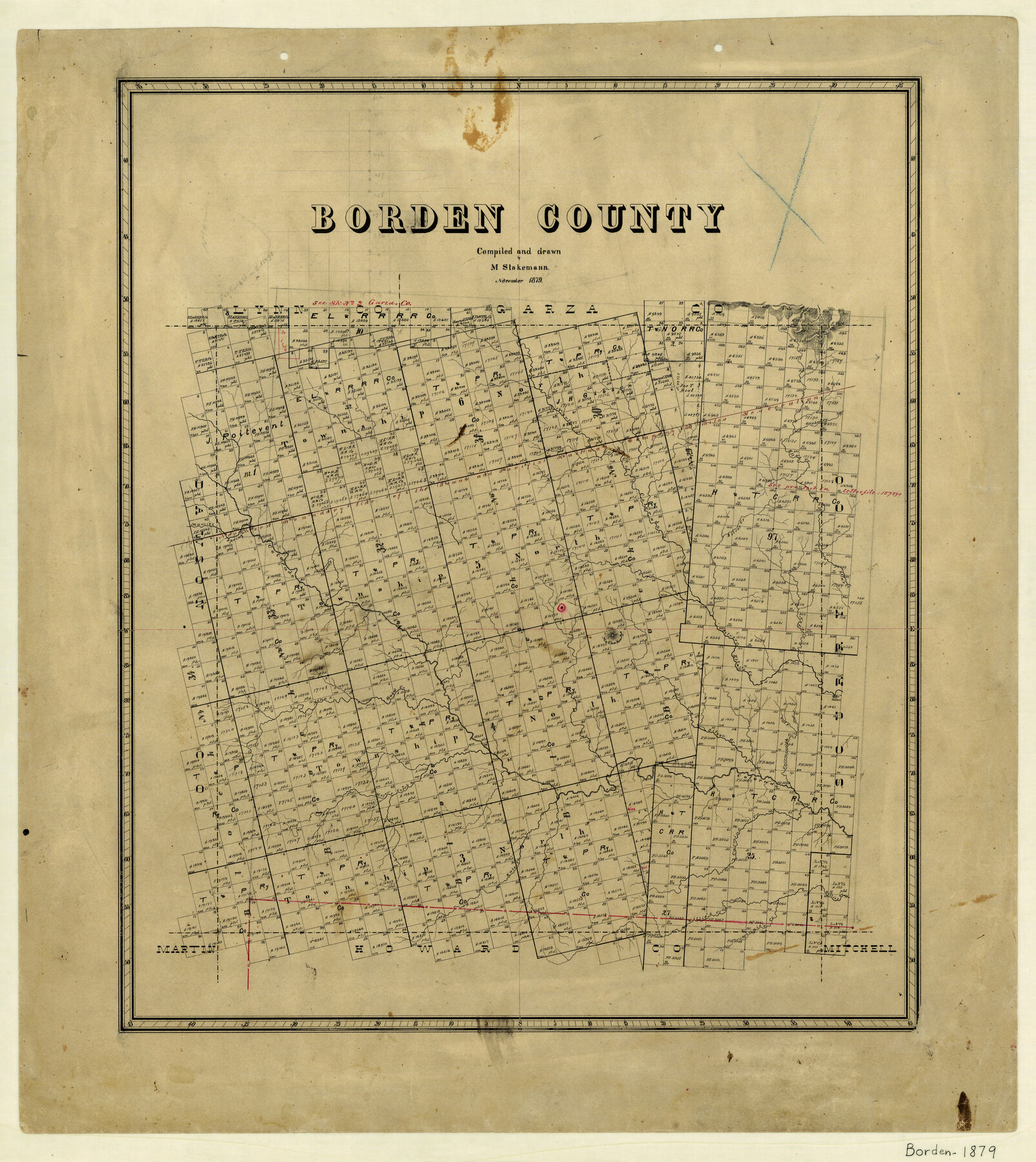
Borden County
-
Map/Doc
3309
-
Collection
General Map Collection
-
Object Dates
11/1879 (Creation Date)
-
People and Organizations
Max Stakemann (Draftsman)
-
Counties
Borden
-
Subjects
County
-
Height x Width
27.4 x 24.4 inches
69.6 x 62.0 cm
-
Features
Gold Creek
Minnie's Creek
Kate Creek
Willie's Creek
Carmine Creek
Meyer's Creek
Red Hill
East Fork of Fairmount Creek
West Fork of Fairmount Creek
Fairmount's Creek
North Fork of Colorado River
Mu Cha Koo Aye Mountain
Silver Creek
Wood's Creek
Colorado River
Spring Creek
Mamie's Creek
Etta's Creek
Gapher Creek
Part of: General Map Collection
Parker County Sketch File 9

Print $4.00
- Digital $50.00
Parker County Sketch File 9
Size 8.1 x 10.0 inches
Map/Doc 33538
Sectional Map No. 4 of the lands and of the lines of the Texas & Pacific R'Y. Co. in El Paso and part of Presidio Co's.

Print $20.00
- Digital $50.00
Sectional Map No. 4 of the lands and of the lines of the Texas & Pacific R'Y. Co. in El Paso and part of Presidio Co's.
1885
Size 22.3 x 17.0 inches
Map/Doc 2304
El Paso County Working Sketch 6

Print $20.00
- Digital $50.00
El Paso County Working Sketch 6
1928
Size 25.4 x 16.7 inches
Map/Doc 69028
Texas 1973 Official Highway Travel Map

Texas 1973 Official Highway Travel Map
Size 28.1 x 36.3 inches
Map/Doc 94406
Angelina County Sketch File 15b

Print $8.00
- Digital $50.00
Angelina County Sketch File 15b
1863
Size 12.7 x 7.9 inches
Map/Doc 12968
Map of Kerr County Texas

Print $20.00
- Digital $50.00
Map of Kerr County Texas
1879
Size 20.3 x 28.3 inches
Map/Doc 3763
Kinney County Sketch File 5

Print $2.00
- Digital $50.00
Kinney County Sketch File 5
Size 5.7 x 13.1 inches
Map/Doc 29123
Baylor County Aerial Photograph Index Sheet 1

Print $20.00
- Digital $50.00
Baylor County Aerial Photograph Index Sheet 1
1950
Size 21.4 x 17.4 inches
Map/Doc 83663
Terrell County Sketch File 21

Print $13.00
- Digital $50.00
Terrell County Sketch File 21
1911
Size 16.4 x 10.3 inches
Map/Doc 37948
Southern Part of Laguna Madre

Print $20.00
- Digital $50.00
Southern Part of Laguna Madre
1972
Size 44.3 x 35.6 inches
Map/Doc 73542
Montgomery County Rolled Sketch 38

Print $40.00
- Digital $50.00
Montgomery County Rolled Sketch 38
1962
Size 56.0 x 30.8 inches
Map/Doc 9545
Map of Leon County

Print $20.00
- Digital $50.00
Map of Leon County
1871
Size 23.6 x 21.2 inches
Map/Doc 3808
You may also like
Edwards County Rolled Sketch 16A

Print $20.00
- Digital $50.00
Edwards County Rolled Sketch 16A
1944
Size 25.0 x 19.0 inches
Map/Doc 5805
Val Verde County Working Sketch 27

Print $20.00
- Digital $50.00
Val Verde County Working Sketch 27
1937
Size 26.6 x 26.4 inches
Map/Doc 72162
No. 2 Chart of Corpus Christi Pass, Texas

Print $20.00
- Digital $50.00
No. 2 Chart of Corpus Christi Pass, Texas
1878
Size 18.3 x 27.3 inches
Map/Doc 73024
Jim Hogg County Working Sketch 1

Print $20.00
- Digital $50.00
Jim Hogg County Working Sketch 1
1933
Size 30.4 x 25.3 inches
Map/Doc 66587
Burnet County Rolled Sketch 5

Print $40.00
- Digital $50.00
Burnet County Rolled Sketch 5
1971
Size 36.5 x 49.6 inches
Map/Doc 8542
Duval County Working Sketch 11

Print $20.00
- Digital $50.00
Duval County Working Sketch 11
1937
Size 24.3 x 19.4 inches
Map/Doc 68724
Medina County Working Sketch 21

Print $20.00
- Digital $50.00
Medina County Working Sketch 21
1982
Size 18.1 x 23.3 inches
Map/Doc 70936
Dr. Ross Trigg's Ranch [Block 29E, Townships 14N and 15N]
![92036, Dr. Ross Trigg's Ranch [Block 29E, Townships 14N and 15N], Twichell Survey Records](https://historictexasmaps.com/wmedia_w700/maps/92036-1.tif.jpg)
Print $20.00
- Digital $50.00
Dr. Ross Trigg's Ranch [Block 29E, Townships 14N and 15N]
Size 25.8 x 19.6 inches
Map/Doc 92036
Maps & Lists Showing Prison Lands (Oil & Gas) Leased as of June 1955

Digital $50.00
Maps & Lists Showing Prison Lands (Oil & Gas) Leased as of June 1955
1930
Size 24.4 x 26.8 inches
Map/Doc 62876
Andrews County Rolled Sketch 33

Print $40.00
- Digital $50.00
Andrews County Rolled Sketch 33
Size 131.2 x 22.0 inches
Map/Doc 9003
Map of the State of Texas from the Latest Authorities

Print $2.00
- Digital $50.00
Map of the State of Texas from the Latest Authorities
1854
Size 5.2 x 3.5 inches
Map/Doc 93902
Calhoun County Sketch File 19

Print $70.00
- Digital $50.00
Calhoun County Sketch File 19
1998
Size 11.1 x 8.1 inches
Map/Doc 35992