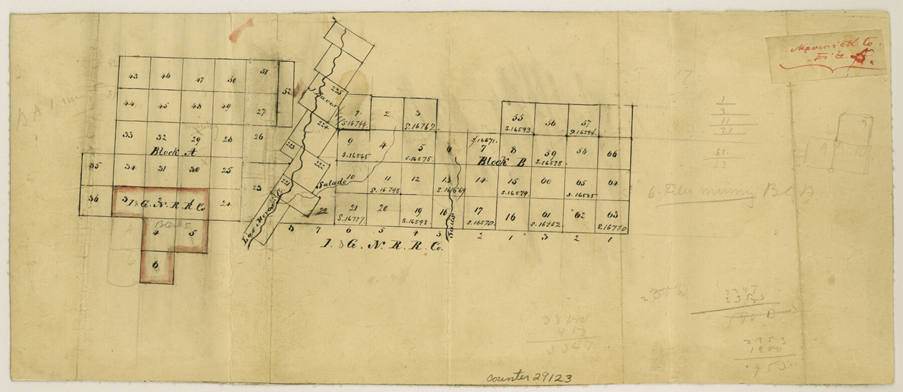
Kinney County Sketch File 5
[Sketch of area in and around Blocks A and B in south part of the county]
-
Map/Doc
29123
-
Collection
General Map Collection
-
Counties
Kinney Maverick
-
Subjects
Surveying Sketch File
-
Height x Width
5.7 x 13.1 inches
14.5 x 33.3 cm
-
Medium
paper, manuscript
-
Features
Salado Creek
Las Meranos Creek
Saus Creek
Part of: General Map Collection
Schleicher County Working Sketch 14

Print $20.00
- Digital $50.00
Schleicher County Working Sketch 14
1928
Size 32.6 x 22.4 inches
Map/Doc 63816
Ector County Sketch File 10

Print $8.00
- Digital $50.00
Ector County Sketch File 10
1930
Size 11.6 x 9.0 inches
Map/Doc 21639
Throckmorton County Sketch File 10

Print $6.00
- Digital $50.00
Throckmorton County Sketch File 10
1955
Size 11.2 x 8.8 inches
Map/Doc 38102
Tyler County Sketch File A1

Print $22.00
- Digital $50.00
Tyler County Sketch File A1
Size 12.7 x 15.7 inches
Map/Doc 38605

Gaines County Rolled Sketch 20

Print $20.00
- Digital $50.00
Gaines County Rolled Sketch 20
1955
Size 30.1 x 37.2 inches
Map/Doc 5936
Flight Mission No. BRE-2P, Frame 80, Nueces County

Print $20.00
- Digital $50.00
Flight Mission No. BRE-2P, Frame 80, Nueces County
1956
Size 18.4 x 22.5 inches
Map/Doc 86775
Texas Official Highway Travel Map

Digital $50.00
Texas Official Highway Travel Map
Size 27.2 x 36.2 inches
Map/Doc 94305
Flight Mission No. BRE-3P, Frame 94, Nueces County

Print $20.00
- Digital $50.00
Flight Mission No. BRE-3P, Frame 94, Nueces County
1956
Size 18.5 x 22.4 inches
Map/Doc 86825
Map of Nacogdoches County

Print $20.00
- Digital $50.00
Map of Nacogdoches County
1881
Size 24.0 x 21.4 inches
Map/Doc 4607
Kleberg County Aerial Photograph Index Sheet 4

Print $20.00
- Digital $50.00
Kleberg County Aerial Photograph Index Sheet 4
1956
Size 19.3 x 23.3 inches
Map/Doc 83721
Brewster County Working Sketch 60

Print $20.00
- Digital $50.00
Brewster County Working Sketch 60
1955
Size 22.3 x 18.2 inches
Map/Doc 67661
You may also like
Potter County Boundary File 4

Print $30.00
- Digital $50.00
Potter County Boundary File 4
Size 14.6 x 9.3 inches
Map/Doc 57997
Terrell County Rolled Sketch 1

Print $20.00
- Digital $50.00
Terrell County Rolled Sketch 1
1906
Size 31.2 x 22.5 inches
Map/Doc 7924
Frio County Working Sketch 26

Print $20.00
- Digital $50.00
Frio County Working Sketch 26
2001
Size 38.0 x 42.7 inches
Map/Doc 69300
[Blocks C-25, C-26, C-27, and 29]
![91320, [Blocks C-25, C-26, C-27, and 29], Twichell Survey Records](https://historictexasmaps.com/wmedia_w700/maps/91320-1.tif.jpg)
Print $20.00
- Digital $50.00
[Blocks C-25, C-26, C-27, and 29]
Size 23.4 x 27.2 inches
Map/Doc 91320
Taylor County Working Sketch 22

Print $40.00
- Digital $50.00
Taylor County Working Sketch 22
1985
Size 50.3 x 37.3 inches
Map/Doc 69632
Calhoun County Rolled Sketch 12

Print $40.00
- Digital $50.00
Calhoun County Rolled Sketch 12
1940
Size 37.9 x 54.6 inches
Map/Doc 66845
Falls County Sketch File 21

Print $4.00
- Digital $50.00
Falls County Sketch File 21
1878
Size 8.7 x 9.0 inches
Map/Doc 22394
Hockley County

Print $20.00
- Digital $50.00
Hockley County
1897
Size 19.1 x 20.5 inches
Map/Doc 3675
Duval County Rolled Sketch 40

Print $20.00
- Digital $50.00
Duval County Rolled Sketch 40
1958
Size 22.8 x 31.1 inches
Map/Doc 5757
[County map showing Texas State Capitol Land and surrounding areas]
![93141, [County map showing Texas State Capitol Land and surrounding areas], Twichell Survey Records](https://historictexasmaps.com/wmedia_w700/maps/93141-1.tif.jpg)
Print $40.00
- Digital $50.00
[County map showing Texas State Capitol Land and surrounding areas]
Size 51.5 x 66.7 inches
Map/Doc 93141
Culberson County Working Sketch 2

Print $20.00
- Digital $50.00
Culberson County Working Sketch 2
Size 27.7 x 18.7 inches
Map/Doc 68454
Exhibit G Robert Violette M. A. 34719 Gaines County, Texas

Print $40.00
- Digital $50.00
Exhibit G Robert Violette M. A. 34719 Gaines County, Texas
Size 56.1 x 23.2 inches
Map/Doc 89683