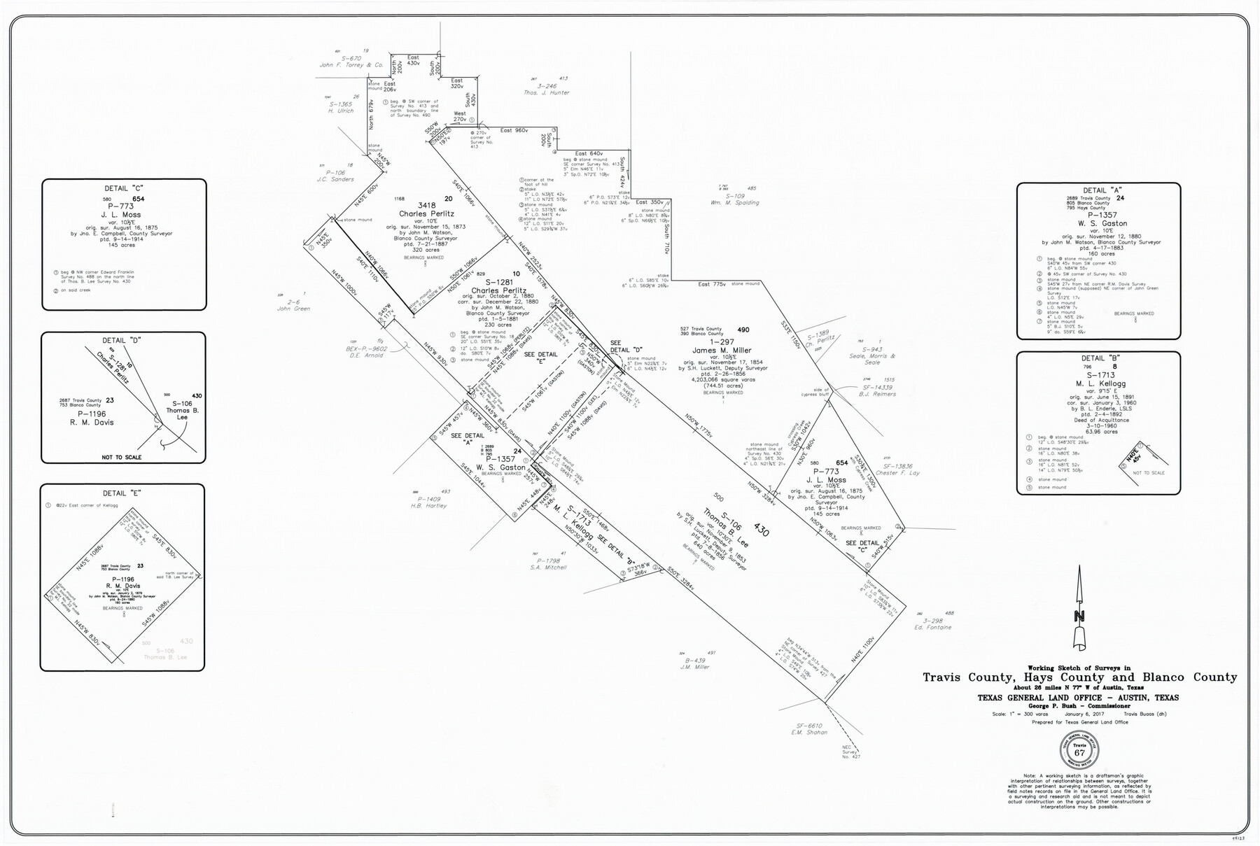
Travis County Working Sketch 67
-
Map/Doc
94123
-
Collection
General Map Collection
-
Object Dates
1/6/2017 (Creation Date)
-
People and Organizations
Travis Buaas (Draftsman)
-
Counties
Travis Hays Blanco
-
Subjects
Surveying Working Sketch
-
Height x Width
24.6 x 36.6 inches
62.5 x 93.0 cm
-
Medium
mylar, print
-
Scale
1" = 300 varas
Part of: General Map Collection
Winkler County Working Sketch 9

Print $40.00
- Digital $50.00
Winkler County Working Sketch 9
1950
Size 42.9 x 50.0 inches
Map/Doc 72603
United States - Gulf Coast - Padre I. and Laguna Madre Lat. 27° 12' to Lat. 26° 33' Texas

Print $20.00
- Digital $50.00
United States - Gulf Coast - Padre I. and Laguna Madre Lat. 27° 12' to Lat. 26° 33' Texas
1913
Size 26.8 x 18.2 inches
Map/Doc 72815
Bosque County Working Sketch 18

Print $20.00
- Digital $50.00
Bosque County Working Sketch 18
1976
Size 18.8 x 24.4 inches
Map/Doc 67451
Gaines County Working Sketch 17

Print $20.00
- Digital $50.00
Gaines County Working Sketch 17
1964
Size 47.6 x 34.5 inches
Map/Doc 69317
Map of Hamilton County

Print $20.00
- Digital $50.00
Map of Hamilton County
1872
Size 15.1 x 22.1 inches
Map/Doc 4555
Menard County Sketch File 13

Print $4.00
- Digital $50.00
Menard County Sketch File 13
1892
Size 12.8 x 8.2 inches
Map/Doc 31506
Fayette County

Print $40.00
- Digital $50.00
Fayette County
1978
Size 43.6 x 56.1 inches
Map/Doc 95496
Texas 1973 Official Highway Travel Map

Texas 1973 Official Highway Travel Map
Size 28.1 x 36.3 inches
Map/Doc 94406
Anderson County Sketch File 6

Print $4.00
- Digital $50.00
Anderson County Sketch File 6
Size 12.5 x 8.2 inches
Map/Doc 12753
Jefferson County Rolled Sketch 29

Print $20.00
- Digital $50.00
Jefferson County Rolled Sketch 29
1952
Size 31.8 x 43.6 inches
Map/Doc 9293
[Map of Val Verde County]
![4110, [Map of Val Verde County], General Map Collection](https://historictexasmaps.com/wmedia_w700/maps/4110-1.tif.jpg)
Print $20.00
- Digital $50.00
[Map of Val Verde County]
1931
Size 36.4 x 24.1 inches
Map/Doc 4110

You may also like
Callahan County, Texas

Print $20.00
- Digital $50.00
Callahan County, Texas
1880
Size 24.1 x 18.4 inches
Map/Doc 681
Flight Mission No. DQN-7K, Frame 91, Calhoun County

Print $20.00
- Digital $50.00
Flight Mission No. DQN-7K, Frame 91, Calhoun County
1953
Size 18.4 x 22.2 inches
Map/Doc 84482
[Surveys in the Bexar District along the Nueces and Leona Rivers]
![116, [Surveys in the Bexar District along the Nueces and Leona Rivers], General Map Collection](https://historictexasmaps.com/wmedia_w700/maps/116.tif.jpg)
Print $3.00
- Digital $50.00
[Surveys in the Bexar District along the Nueces and Leona Rivers]
1845
Size 10.9 x 14.3 inches
Map/Doc 116
Flight Mission No. CUG-3P, Frame 21, Kleberg County

Print $20.00
- Digital $50.00
Flight Mission No. CUG-3P, Frame 21, Kleberg County
1956
Size 18.6 x 22.2 inches
Map/Doc 86231
Navarro County Sketch File 13

Print $22.00
- Digital $50.00
Navarro County Sketch File 13
Size 12.0 x 8.6 inches
Map/Doc 32324
Harris County Boundary File 39 (13)

Print $60.00
- Digital $50.00
Harris County Boundary File 39 (13)
Size 13.1 x 15.9 inches
Map/Doc 54341
Flight Mission No. DQN-5K, Frame 44, Calhoun County

Print $20.00
- Digital $50.00
Flight Mission No. DQN-5K, Frame 44, Calhoun County
1953
Size 18.4 x 22.0 inches
Map/Doc 84389
Atascosa County Rolled Sketch 22

Print $40.00
- Digital $50.00
Atascosa County Rolled Sketch 22
1917
Size 57.8 x 27.1 inches
Map/Doc 8919
Falls County Sketch File 25

Print $7.00
- Digital $50.00
Falls County Sketch File 25
1968
Size 10.4 x 8.2 inches
Map/Doc 22430
[Cotton Belt, St. Louis Southwestern Railway of Texas, Alignment through Smith County]
![64384, [Cotton Belt, St. Louis Southwestern Railway of Texas, Alignment through Smith County], General Map Collection](https://historictexasmaps.com/wmedia_w700/maps/64384.tif.jpg)
Print $20.00
- Digital $50.00
[Cotton Belt, St. Louis Southwestern Railway of Texas, Alignment through Smith County]
1903
Size 21.4 x 29.9 inches
Map/Doc 64384
Flight Mission No. CGI-1N, Frame 142, Cameron County

Print $20.00
- Digital $50.00
Flight Mission No. CGI-1N, Frame 142, Cameron County
1955
Size 18.5 x 22.2 inches
Map/Doc 84498
Upton County Sketch File 11

Print $20.00
- Digital $50.00
Upton County Sketch File 11
1919
Size 22.5 x 27.6 inches
Map/Doc 12511