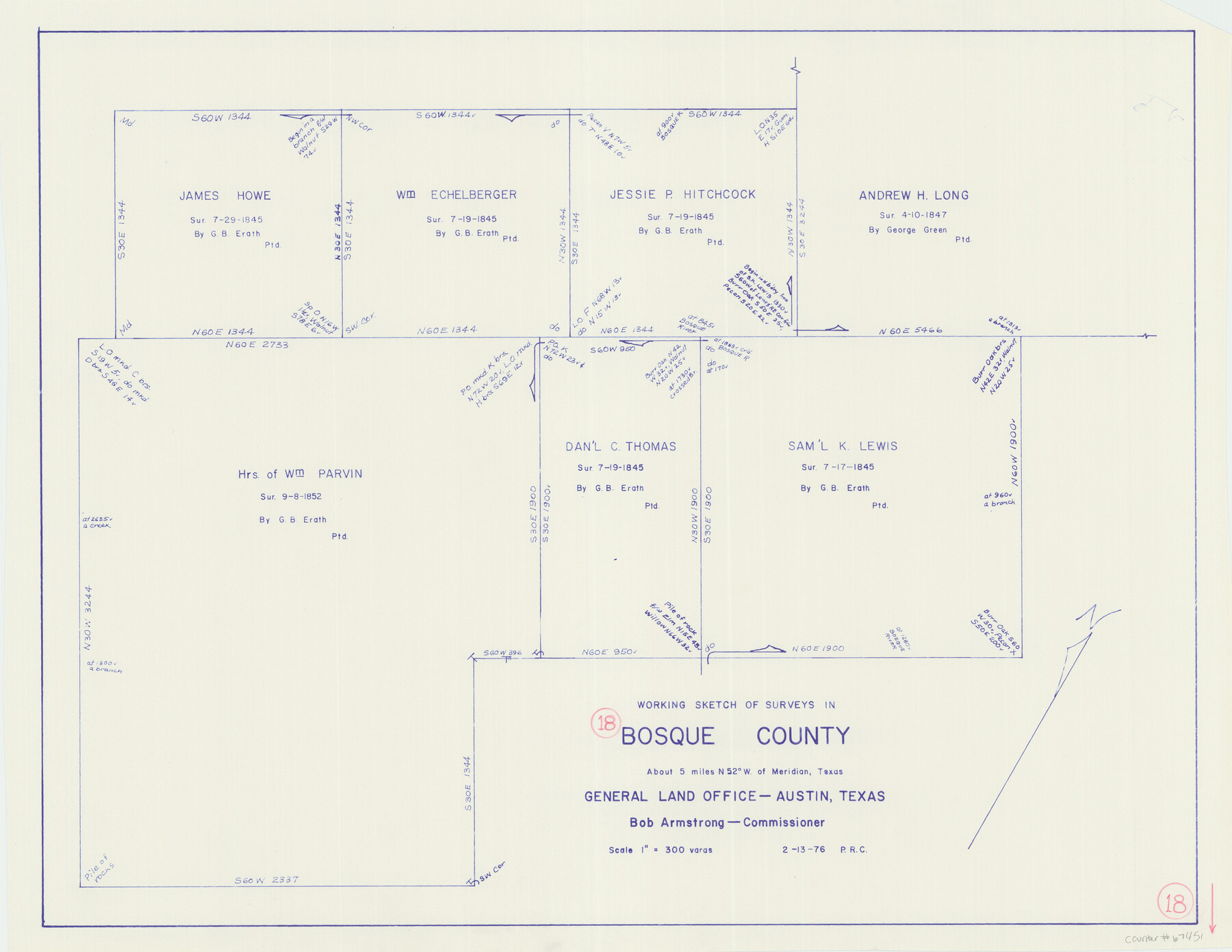
Bosque County Working Sketch 18
-
Map/Doc
67451
-
Collection
General Map Collection
-
Object Dates
2/13/1976 (Creation Date)
-
People and Organizations
Bob Armstrong (GLO Commissioner)
Preston R. Connelly (Draftsman)
-
Counties
Bosque
-
Subjects
Surveying Working Sketch
-
Height x Width
18.8 x 24.4 inches
47.8 x 62.0 cm
-
Scale
1" = 300 varas
-
Comments
Surveys located about five miles North 52 degrees West of Meridian, Texas.
Part of: General Map Collection
Terrell County Working Sketch 26

Print $20.00
- Digital $50.00
Terrell County Working Sketch 26
1943
Size 17.5 x 14.0 inches
Map/Doc 62176
Coleman County Sketch File 17

Print $4.00
- Digital $50.00
Coleman County Sketch File 17
Size 12.6 x 7.9 inches
Map/Doc 18685
Garza County Working Sketch 1

Print $20.00
- Digital $50.00
Garza County Working Sketch 1
1902
Size 39.3 x 25.6 inches
Map/Doc 63148
El Paso County Working Sketch 11

Print $40.00
- Digital $50.00
El Paso County Working Sketch 11
1955
Size 49.2 x 43.4 inches
Map/Doc 69033
Duval County Sketch File 75

Print $20.00
- Digital $50.00
Duval County Sketch File 75
1935
Size 18.0 x 28.5 inches
Map/Doc 11409
Duval County Sketch File 19b

Print $6.00
- Digital $50.00
Duval County Sketch File 19b
Size 15.4 x 9.7 inches
Map/Doc 21320
Brewster County Rolled Sketch 113

Print $171.00
- Digital $50.00
Brewster County Rolled Sketch 113
1975
Map/Doc 9565
San Augustine County Working Sketch 14

Print $20.00
- Digital $50.00
San Augustine County Working Sketch 14
1958
Size 22.7 x 26.1 inches
Map/Doc 63702
Marion County Sketch File 1b

Print $8.00
- Digital $50.00
Marion County Sketch File 1b
Size 12.4 x 7.7 inches
Map/Doc 30560
Winkler County Rolled Sketch 11

Print $20.00
- Digital $50.00
Winkler County Rolled Sketch 11
1965
Size 37.4 x 34.2 inches
Map/Doc 10152
Montgomery County Rolled Sketch 14

Print $20.00
- Digital $50.00
Montgomery County Rolled Sketch 14
Size 22.4 x 25.4 inches
Map/Doc 6803
Texas, Corpus Christi Bay, Nueces Bay

Print $40.00
- Digital $50.00
Texas, Corpus Christi Bay, Nueces Bay
1934
Size 34.0 x 48.9 inches
Map/Doc 73458
You may also like
Duval County Working Sketch 39

Print $20.00
- Digital $50.00
Duval County Working Sketch 39
1960
Size 27.1 x 28.9 inches
Map/Doc 68763
Starr County Working Sketch 11

Print $20.00
- Digital $50.00
Starr County Working Sketch 11
1944
Size 18.1 x 17.7 inches
Map/Doc 63927
Map of Burnet County

Print $20.00
- Digital $50.00
Map of Burnet County
1876
Size 24.5 x 21.3 inches
Map/Doc 3352
Ownership Map of McCulloch County, Texas

Print $20.00
- Digital $50.00
Ownership Map of McCulloch County, Texas
1951
Size 40.5 x 32.5 inches
Map/Doc 3138
Randall County Sketch File 8

Print $20.00
- Digital $50.00
Randall County Sketch File 8
Size 18.1 x 23.1 inches
Map/Doc 12209
Matagorda County Working Sketch 20

Print $20.00
- Digital $50.00
Matagorda County Working Sketch 20
1961
Size 26.1 x 37.7 inches
Map/Doc 70878
Cooke County Sketch File 22

Print $6.00
- Digital $50.00
Cooke County Sketch File 22
1870
Size 6.4 x 8.2 inches
Map/Doc 19267
Bell County Sketch File 23a

Print $6.00
- Digital $50.00
Bell County Sketch File 23a
1873
Size 10.0 x 15.7 inches
Map/Doc 14416
Edwards County Rolled Sketch 30

Print $20.00
- Digital $50.00
Edwards County Rolled Sketch 30
1980
Size 31.6 x 44.0 inches
Map/Doc 8848
Trinity River, Bazzette Sheet

Print $20.00
- Digital $50.00
Trinity River, Bazzette Sheet
1925
Size 27.9 x 23.8 inches
Map/Doc 78339
Right of Way and Track Map of The Wichita Falls & Southern Railroad Company

Print $40.00
- Digital $50.00
Right of Way and Track Map of The Wichita Falls & Southern Railroad Company
1942
Size 24.6 x 56.1 inches
Map/Doc 64519
Township No. 5 South Range No. 15 West of the Indian Meridian

Print $4.00
- Digital $50.00
Township No. 5 South Range No. 15 West of the Indian Meridian
1875
Size 18.1 x 23.1 inches
Map/Doc 75138