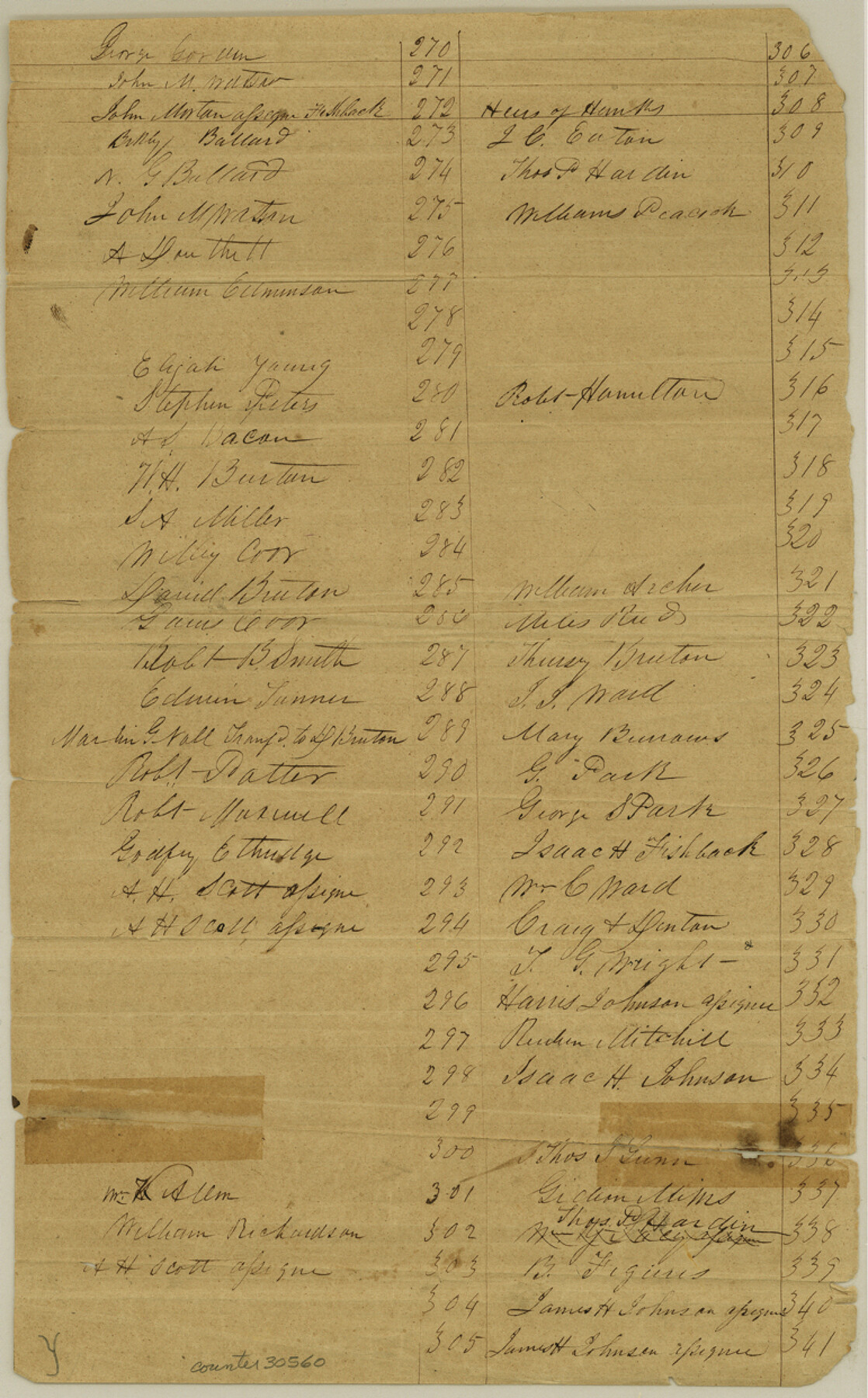
Marion County Sketch File 1b
[List of surveys on map of Paschal County]
-
Map/Doc
30560
-
Collection
General Map Collection
-
Counties
Marion Paschal
-
Subjects
Surveying Sketch File
-
Height x Width
12.4 x 7.7 inches
31.5 x 19.6 cm
-
Medium
paper, manuscript
Part of: General Map Collection
Pecos County Working Sketch 103

Print $40.00
- Digital $50.00
Pecos County Working Sketch 103
1971
Size 43.4 x 51.4 inches
Map/Doc 71576
Hamilton County Rolled Sketch 14

Print $20.00
- Digital $50.00
Hamilton County Rolled Sketch 14
1989
Size 28.0 x 40.0 inches
Map/Doc 6063
[Atlas A, Table of Contents, part 1]
![78351, [Atlas A, Table of Contents, part 1], General Map Collection](https://historictexasmaps.com/wmedia_w700/maps/78351.tif.jpg)
Print $20.00
- Digital $50.00
[Atlas A, Table of Contents, part 1]
Size 14.5 x 15.0 inches
Map/Doc 78351
Real County Boundary File 1

Print $8.00
- Digital $50.00
Real County Boundary File 1
Size 9.3 x 5.9 inches
Map/Doc 58191
[Location St. L. & S. W. R. R. Through Cherokee County]
![64042, [Location St. L. & S. W. R. R. Through Cherokee County], General Map Collection](https://historictexasmaps.com/wmedia_w700/maps/64042-1.tif.jpg)
Print $40.00
- Digital $50.00
[Location St. L. & S. W. R. R. Through Cherokee County]
Size 92.0 x 39.9 inches
Map/Doc 64042
Edwards County Sketch File 13

Print $6.00
- Digital $50.00
Edwards County Sketch File 13
1888
Size 11.1 x 7.1 inches
Map/Doc 21700
PSL Field Notes for Blocks A27 and A28 in Andrews and Gaines Counties, and Blocks A6 through A13, A20 through A26, and A30 in Gaines County

PSL Field Notes for Blocks A27 and A28 in Andrews and Gaines Counties, and Blocks A6 through A13, A20 through A26, and A30 in Gaines County
Map/Doc 81654
Wichita County Working Sketch 21

Print $20.00
- Digital $50.00
Wichita County Working Sketch 21
1951
Size 28.4 x 30.2 inches
Map/Doc 72531
Lavaca County Working Sketch 6

Print $20.00
- Digital $50.00
Lavaca County Working Sketch 6
1941
Size 20.8 x 22.0 inches
Map/Doc 70359
Tarrant County Sketch File 14

Print $7.00
- Digital $50.00
Tarrant County Sketch File 14
1859
Size 10.2 x 8.4 inches
Map/Doc 37705
Jones County Boundary File 1a

Print $40.00
- Digital $50.00
Jones County Boundary File 1a
1882
Size 37.9 x 39.2 inches
Map/Doc 44358
Castro County Working Sketch 2

Print $20.00
- Digital $50.00
Castro County Working Sketch 2
Size 30.4 x 26.2 inches
Map/Doc 67897
You may also like
Map of a Route from Austin-City to Paso del Norte & c.

Print $20.00
- Digital $50.00
Map of a Route from Austin-City to Paso del Norte & c.
1849
Size 11.7 x 30.5 inches
Map/Doc 2121
La Salle County

Print $20.00
- Digital $50.00
La Salle County
1886
Size 25.4 x 21.3 inches
Map/Doc 3795
Tom Green County Sketch File 75

Print $20.00
- Digital $50.00
Tom Green County Sketch File 75
1950
Size 18.1 x 22.5 inches
Map/Doc 12449
Trinity County Working Sketch Graphic Index

Print $20.00
- Digital $50.00
Trinity County Working Sketch Graphic Index
1946
Size 41.3 x 41.6 inches
Map/Doc 76718
Val Verde County Rolled Sketch 10

Print $20.00
- Digital $50.00
Val Verde County Rolled Sketch 10
Size 22.9 x 27.8 inches
Map/Doc 8108
Morris County Boundary File 2

Print $6.00
- Digital $50.00
Morris County Boundary File 2
Size 14.1 x 8.7 inches
Map/Doc 57482
Montague County Sketch File 3

Print $3.00
- Digital $50.00
Montague County Sketch File 3
1855
Size 15.5 x 10.2 inches
Map/Doc 31714
Angelina County Working Sketch 37

Print $20.00
- Digital $50.00
Angelina County Working Sketch 37
1958
Size 25.7 x 19.1 inches
Map/Doc 67120

Brewster County Rolled Sketch 89

Print $40.00
- Digital $50.00
Brewster County Rolled Sketch 89
1947
Size 37.3 x 63.4 inches
Map/Doc 8499
Frio County Working Sketch 1

Print $20.00
- Digital $50.00
Frio County Working Sketch 1
1906
Size 19.0 x 23.2 inches
Map/Doc 69275
Starr County Working Sketch 19

Print $20.00
- Digital $50.00
Starr County Working Sketch 19
1982
Size 27.3 x 33.9 inches
Map/Doc 63935