Starr County Sketch File 25
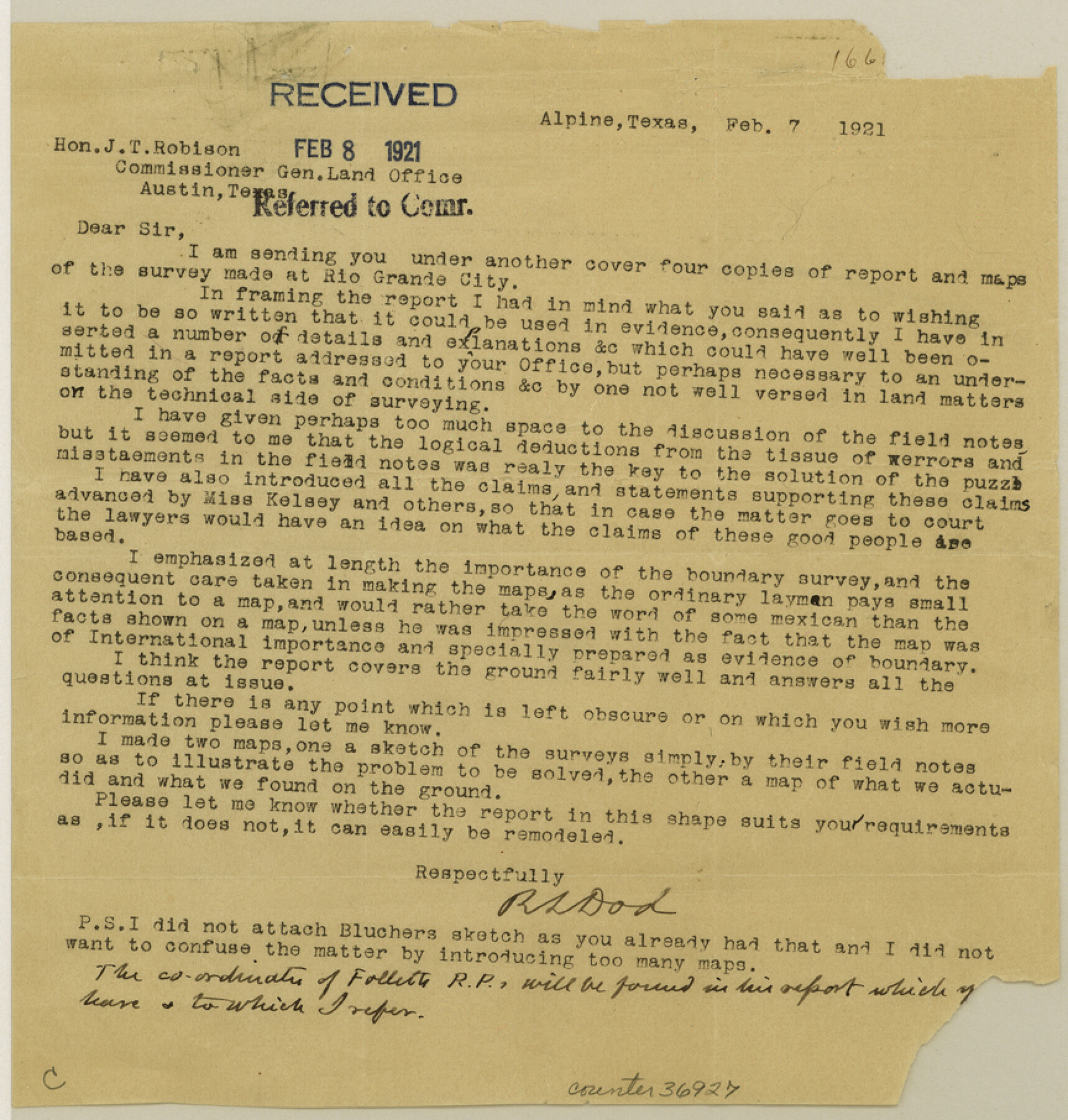
Report [and related correspondence] of a resurvey of porciones 80-90 inclusive
-
Map/Doc
36927
-
Collection
General Map Collection
-
Object Dates
2/7/1921 (Creation Date)
2/8/1921 (File Date)
1/1921 (Survey Date)
2/3/1923 (Correspondence Date)
5/31/1923 (Correspondence Date)
6/4/1923 (File Date)
-
People and Organizations
R.S. Dod (Surveyor/Engineer)
J.S. Monroe (Surveyor/Engineer)
-
Counties
Starr
-
Subjects
Surveying Sketch File
-
Height x Width
9.1 x 8.6 inches
23.1 x 21.8 cm
-
Medium
paper, print
-
Comments
See Starr County Sketch File 23 (36919) for related report, Starr County Sketch File 24 (12332) for sketch, and Starr County Sketch File 22 (12331) for work by J.S. Monroe.
-
Features
Banco San Domingo
El Junco Waterhole
Pecos River
Old San Antonio Road
Falfurias Road
Corpus Christi Road
Garcia Church
Fort Riggold
Los Olmos Creek
Brownsville Road
Rio Grande City
First Street
Britton Avenue
Garcia Ranch
La Cruz Ranch
Rio Grande to Brownsville Road
Emory Channel
San Juan
Rio Grande
Related maps
Starr County Sketch File 22

Print $20.00
- Digital $50.00
Starr County Sketch File 22
1922
Size 16.4 x 35.9 inches
Map/Doc 12331
Starr County Sketch File 24

Print $20.00
- Digital $50.00
Starr County Sketch File 24
1922
Size 15.7 x 19.5 inches
Map/Doc 12332
Starr County Sketch File 23

Print $16.00
- Digital $50.00
Starr County Sketch File 23
1922
Size 10.7 x 8.8 inches
Map/Doc 36919
Part of: General Map Collection
Flight Mission No. CRC-4R, Frame 153, Chambers County

Print $20.00
- Digital $50.00
Flight Mission No. CRC-4R, Frame 153, Chambers County
1956
Size 18.7 x 22.4 inches
Map/Doc 84916
Dry Fork of Brushy Creek

Print $2.00
- Digital $50.00
Dry Fork of Brushy Creek
Size 7.1 x 6.8 inches
Map/Doc 78380
Hardeman County Working Sketch 18

Print $20.00
- Digital $50.00
Hardeman County Working Sketch 18
2002
Size 33.5 x 36.5 inches
Map/Doc 76401
Nueces County Sketch File A

Print $10.00
- Digital $50.00
Nueces County Sketch File A
1879
Size 14.9 x 10.3 inches
Map/Doc 32493
Parker County Working Sketch 3

Print $20.00
- Digital $50.00
Parker County Working Sketch 3
1941
Map/Doc 71453
Gillespie County Rolled Sketch 4

Print $20.00
- Digital $50.00
Gillespie County Rolled Sketch 4
1994
Size 23.3 x 27.1 inches
Map/Doc 6011
Houston County Working Sketch 12

Print $20.00
- Digital $50.00
Houston County Working Sketch 12
1956
Size 24.0 x 27.3 inches
Map/Doc 66242
Waller County Working Sketch 3

Print $20.00
- Digital $50.00
Waller County Working Sketch 3
1959
Size 35.4 x 28.8 inches
Map/Doc 72302
Presidio County Sketch File 76

Print $20.00
- Digital $50.00
Presidio County Sketch File 76
Size 22.0 x 18.3 inches
Map/Doc 11720
Post Route Map of the State of Texas with adjacent parts of Louisiana, Arkansas, Indian Territory, and of the Republic of Mexico showing post offices with the intermediate and mail routes in operation on the 1st of December, 1892

Print $40.00
- Digital $50.00
Post Route Map of the State of Texas with adjacent parts of Louisiana, Arkansas, Indian Territory, and of the Republic of Mexico showing post offices with the intermediate and mail routes in operation on the 1st of December, 1892
1889
Size 44.0 x 57.3 inches
Map/Doc 94080
Hemphill County Working Sketch 35

Print $20.00
- Digital $50.00
Hemphill County Working Sketch 35
1978
Size 35.9 x 44.8 inches
Map/Doc 66130
Knox County Sketch File 21

Print $16.00
- Digital $50.00
Knox County Sketch File 21
1917
Size 3.7 x 8.6 inches
Map/Doc 29243
You may also like
Webb County Sketch File 13a

Print $20.00
- Digital $50.00
Webb County Sketch File 13a
1881
Size 19.0 x 25.7 inches
Map/Doc 12631
Map of the City of Barry, John McGowan & J.B. & A. Adams Surveys, Navarro County, Texas

Print $20.00
- Digital $50.00
Map of the City of Barry, John McGowan & J.B. & A. Adams Surveys, Navarro County, Texas
1958
Size 28.4 x 25.4 inches
Map/Doc 94015
Pecos County Working Sketch 3

Print $20.00
- Digital $50.00
Pecos County Working Sketch 3
1927
Map/Doc 71473
Vereinigte Staaten von Nord America

Print $20.00
- Digital $50.00
Vereinigte Staaten von Nord America
1828
Size 17.6 x 21.9 inches
Map/Doc 93644
Tom Green County Sketch File 73

Print $12.00
- Digital $50.00
Tom Green County Sketch File 73
1949
Size 11.2 x 8.8 inches
Map/Doc 38244
Mason County Sketch File 14

Print $20.00
- Digital $50.00
Mason County Sketch File 14
1884
Size 15.2 x 16.4 inches
Map/Doc 12035
Louisiana and Texas Intracoastal Waterway, Section 7, Galveston Bay to Brazos River and Section 8, Brazos River to Matagorda Bay

Print $20.00
- Digital $50.00
Louisiana and Texas Intracoastal Waterway, Section 7, Galveston Bay to Brazos River and Section 8, Brazos River to Matagorda Bay
1937
Size 30.7 x 42.7 inches
Map/Doc 73064
Brewster County Rolled Sketch 61

Print $40.00
- Digital $50.00
Brewster County Rolled Sketch 61
1939
Size 43.7 x 70.3 inches
Map/Doc 8486
Wichita County Working Sketch 7

Print $20.00
- Digital $50.00
Wichita County Working Sketch 7
1919
Size 20.8 x 13.6 inches
Map/Doc 72516
Map of Shackelford County

Print $20.00
- Digital $50.00
Map of Shackelford County
1895
Size 24.1 x 19.5 inches
Map/Doc 4026
Flight Mission No. CLL-1N, Frame 188, Willacy County

Print $20.00
- Digital $50.00
Flight Mission No. CLL-1N, Frame 188, Willacy County
1954
Size 18.4 x 22.0 inches
Map/Doc 87058
Map of San Antonio Showing Original Townsite in Relation to Mission Valero

Map of San Antonio Showing Original Townsite in Relation to Mission Valero
2017
Size 11.0 x 8.5 inches
Map/Doc 94244