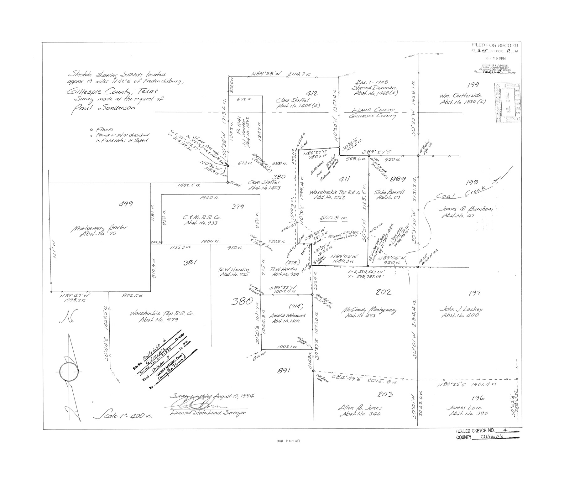
Gillespie County Rolled Sketch 4
Sketch showing surveys located approx. 19 miles N 42° E of Fredericksburg, Gillespie County, Texas survey made at the request of Paul Sanderson
-
Map/Doc
6011
-
Collection
General Map Collection
-
Object Dates
1994/8/10 (Creation Date)
1994/10/3 (File Date)
-
People and Organizations
Charles Ottmers (Surveyor/Engineer)
-
Counties
Gillespie Llano
-
Subjects
Surveying Rolled Sketch
-
Height x Width
23.3 x 27.1 inches
59.2 x 68.8 cm
-
Medium
mylar, print
-
Scale
1" = 400 varas
Part of: General Map Collection
Flight Mission No. CUG-2P, Frame 87, Kleberg County

Print $20.00
- Digital $50.00
Flight Mission No. CUG-2P, Frame 87, Kleberg County
1956
Size 18.4 x 22.2 inches
Map/Doc 86219
[Surveys between the Sabine River and Little Cypress Creek]
![139, [Surveys between the Sabine River and Little Cypress Creek], General Map Collection](https://historictexasmaps.com/wmedia_w700/maps/139.tif.jpg)
Print $3.00
- Digital $50.00
[Surveys between the Sabine River and Little Cypress Creek]
1840
Size 9.3 x 13.0 inches
Map/Doc 139
Brazoria County NRC Article 33.136 Sketch 18

Print $24.00
- Digital $50.00
Brazoria County NRC Article 33.136 Sketch 18
2015
Size 24.0 x 36.0 inches
Map/Doc 95066
Zavala County Sketch File 43

Print $20.00
- Digital $50.00
Zavala County Sketch File 43
1915
Size 26.8 x 32.4 inches
Map/Doc 12733
Intracoastal Waterway in Texas - Corpus Christi to Point Isabel including Arroyo Colorado to Mo. Pac. R.R. Bridge Near Harlingen

Print $20.00
- Digital $50.00
Intracoastal Waterway in Texas - Corpus Christi to Point Isabel including Arroyo Colorado to Mo. Pac. R.R. Bridge Near Harlingen
1933
Size 28.0 x 40.8 inches
Map/Doc 61849
Bandera County Sketch File 25

Print $6.00
- Digital $50.00
Bandera County Sketch File 25
Size 10.6 x 15.9 inches
Map/Doc 10896
Kent County Sketch File 12

Print $20.00
- Digital $50.00
Kent County Sketch File 12
1911
Size 26.8 x 23.6 inches
Map/Doc 11916
Irion County Sketch File 18

Print $10.00
- Digital $50.00
Irion County Sketch File 18
Size 11.2 x 8.7 inches
Map/Doc 27494
Connected Map of Austin's Colony (1892 tracing)

Print $40.00
- Digital $50.00
Connected Map of Austin's Colony (1892 tracing)
1837
Size 90.8 x 46.5 inches
Map/Doc 93359
El Paso County Rolled Sketch 30

Print $20.00
- Digital $50.00
El Paso County Rolled Sketch 30
1906
Size 40.9 x 22.8 inches
Map/Doc 5825
Flight Mission No. DQO-1K, Frame 149, Galveston County

Print $20.00
- Digital $50.00
Flight Mission No. DQO-1K, Frame 149, Galveston County
1952
Size 19.0 x 22.8 inches
Map/Doc 85002
Edwards County Sketch File A1

Print $6.00
- Digital $50.00
Edwards County Sketch File A1
Size 8.5 x 8.8 inches
Map/Doc 21659
You may also like
Kaufman County Sketch File 6

Print $4.00
- Digital $50.00
Kaufman County Sketch File 6
1847
Size 8.2 x 10.0 inches
Map/Doc 28634
Brewster County Rolled Sketch 64

Print $20.00
- Digital $50.00
Brewster County Rolled Sketch 64
1940
Size 17.1 x 21.0 inches
Map/Doc 5232
Aransas County Sketch File 31

Print $46.00
- Digital $50.00
Aransas County Sketch File 31
1919
Size 14.2 x 8.7 inches
Map/Doc 13274
Fayette County Sketch File 6

Print $114.00
- Digital $50.00
Fayette County Sketch File 6
1981
Size 14.9 x 9.5 inches
Map/Doc 22508
Ward County Rolled Sketch 21

Print $20.00
- Digital $50.00
Ward County Rolled Sketch 21
1951
Size 21.1 x 43.3 inches
Map/Doc 8163
Working Sketch in Bastrop County

Print $20.00
- Digital $50.00
Working Sketch in Bastrop County
1923
Size 18.4 x 14.6 inches
Map/Doc 90203
Flight Mission No. CGI-1N, Frame 134, Cameron County

Print $20.00
- Digital $50.00
Flight Mission No. CGI-1N, Frame 134, Cameron County
1955
Size 18.5 x 22.1 inches
Map/Doc 84490
Wilbarger County Sketch File 8

Print $4.00
- Digital $50.00
Wilbarger County Sketch File 8
1885
Size 14.2 x 8.6 inches
Map/Doc 40179
Hamilton County Working Sketch 13

Print $40.00
- Digital $50.00
Hamilton County Working Sketch 13
1949
Size 43.5 x 57.0 inches
Map/Doc 63351
Survey plat of lots 2, 4, 6, 8, 10-16, Block 322 of the original town site of Jourdanton known as School File 154507

Print $4.00
- Digital $50.00
Survey plat of lots 2, 4, 6, 8, 10-16, Block 322 of the original town site of Jourdanton known as School File 154507
2001
Size 26.0 x 27.7 inches
Map/Doc 60392
Glasscock County Working Sketch 2

Print $20.00
- Digital $50.00
Glasscock County Working Sketch 2
Size 32.0 x 28.0 inches
Map/Doc 63175
A Little Journey through the Lower Valley of the Rio Grande - The Magic Valley of Texas

A Little Journey through the Lower Valley of the Rio Grande - The Magic Valley of Texas
1928
Map/Doc 96741