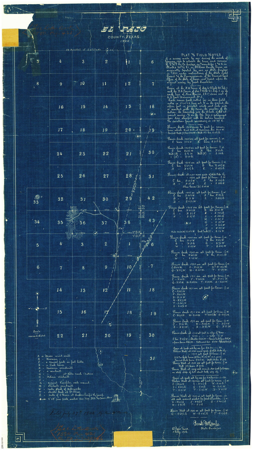
El Paso County Rolled Sketch 30
Plat and field notes of a survey made to relocate the lines and corners of T. & P. Ry. Co. surveys in Townships 1 and 2 in Blocks 80 and 81 in El Paso County, Texas
-
Map/Doc
5825
-
Collection
General Map Collection
-
Object Dates
2/3/1906 (Creation Date)
7/27/1906 (File Date)
-
People and Organizations
Paul McCombs (Surveyor/Engineer)
-
Counties
El Paso
-
Subjects
Surveying Rolled Sketch
-
Height x Width
40.9 x 22.8 inches
103.9 x 57.9 cm
-
Medium
blueprint/diazo
-
Scale
1" = 1000 varas
Part of: General Map Collection
Kimble County Sketch File 28

Print $20.00
- Digital $50.00
Kimble County Sketch File 28
Size 23.3 x 17.8 inches
Map/Doc 11927
[Galveston, Harrisburg & San Antonio from El Paso-Presidio county boundary to Presidio-Pecos county boundary]
![64718, [Galveston, Harrisburg & San Antonio from El Paso-Presidio county boundary to Presidio-Pecos county boundary], General Map Collection](https://historictexasmaps.com/wmedia_w700/maps/64718.tif.jpg)
Print $40.00
- Digital $50.00
[Galveston, Harrisburg & San Antonio from El Paso-Presidio county boundary to Presidio-Pecos county boundary]
Size 106.1 x 44.3 inches
Map/Doc 64718
Harris County Sketch File 73

Print $6.00
- Digital $50.00
Harris County Sketch File 73
1942
Size 11.3 x 8.9 inches
Map/Doc 25539
Cameron County Rolled Sketch 25

Print $20.00
- Digital $50.00
Cameron County Rolled Sketch 25
1977
Size 24.9 x 36.7 inches
Map/Doc 5799
Ward County Rolled Sketch 13

Print $20.00
- Digital $50.00
Ward County Rolled Sketch 13
1938
Size 30.0 x 20.0 inches
Map/Doc 8156
Frio County Sketch File 22

Print $10.00
- Digital $50.00
Frio County Sketch File 22
1994
Size 11.4 x 8.6 inches
Map/Doc 23162
Flight Mission No. BRA-3M, Frame 199, Jefferson County

Print $20.00
- Digital $50.00
Flight Mission No. BRA-3M, Frame 199, Jefferson County
1953
Size 18.6 x 22.3 inches
Map/Doc 85414
[Map of the City of Austin]
![4802, [Map of the City of Austin], General Map Collection](https://historictexasmaps.com/wmedia_w700/maps/4802-1.tif.jpg)
Print $20.00
- Digital $50.00
[Map of the City of Austin]
1856
Size 29.1 x 21.5 inches
Map/Doc 4802
Kimble County Rolled Sketch 37

Print $20.00
- Digital $50.00
Kimble County Rolled Sketch 37
1982
Size 21.6 x 28.0 inches
Map/Doc 6527
Jim Hogg County Working Sketch 5

Print $20.00
- Digital $50.00
Jim Hogg County Working Sketch 5
1941
Size 40.8 x 41.0 inches
Map/Doc 66591
Frio County Rolled Sketch 24

Print $20.00
- Digital $50.00
Frio County Rolled Sketch 24
1964
Size 22.3 x 21.1 inches
Map/Doc 5924
Current Miscellaneous File 117

Print $8.00
- Digital $50.00
Current Miscellaneous File 117
2001
Size 11.2 x 8.8 inches
Map/Doc 74823
You may also like
Working Sketch of Moore County

Print $20.00
- Digital $50.00
Working Sketch of Moore County
Size 27.7 x 15.6 inches
Map/Doc 93002
Lamar County Sketch File 3

Print $6.00
- Digital $50.00
Lamar County Sketch File 3
1864
Size 14.2 x 8.6 inches
Map/Doc 29275
The Republic County of Bexar. December 31, 1838

Print $20.00
The Republic County of Bexar. December 31, 1838
2020
Size 24.6 x 21.6 inches
Map/Doc 96096
Cochran County Sketch File 8

Print $32.00
- Digital $50.00
Cochran County Sketch File 8
1940
Size 11.0 x 8.8 inches
Map/Doc 18555
Rains County Sketch File 6

Print $4.00
- Digital $50.00
Rains County Sketch File 6
Size 8.0 x 9.1 inches
Map/Doc 34954
[Surveys along Gilleland and Wilbarger Creek in the Travis District]
![111, [Surveys along Gilleland and Wilbarger Creek in the Travis District], General Map Collection](https://historictexasmaps.com/wmedia_w700/maps/111.tif.jpg)
Print $2.00
- Digital $50.00
[Surveys along Gilleland and Wilbarger Creek in the Travis District]
1841
Size 8.1 x 11.2 inches
Map/Doc 111
Flight Mission No. DCL-5C, Frame 30, Kenedy County

Print $20.00
- Digital $50.00
Flight Mission No. DCL-5C, Frame 30, Kenedy County
1943
Size 18.6 x 22.3 inches
Map/Doc 85842
Kimble County Working Sketch 24

Print $20.00
- Digital $50.00
Kimble County Working Sketch 24
1930
Size 23.3 x 17.4 inches
Map/Doc 70092
Randall County Boundary File 4

Print $10.00
- Digital $50.00
Randall County Boundary File 4
Size 14.4 x 8.9 inches
Map/Doc 58129
Bee County Sketch File 31

Print $6.00
- Digital $50.00
Bee County Sketch File 31
1886
Size 12.8 x 8.2 inches
Map/Doc 14344
Flight Mission No. CRK-7P, Frame 133, Refugio County

Print $20.00
- Digital $50.00
Flight Mission No. CRK-7P, Frame 133, Refugio County
1956
Size 18.3 x 22.1 inches
Map/Doc 86956
Brazoria County NRC Article 33.136 Sketch 14

Print $36.00
- Digital $50.00
Brazoria County NRC Article 33.136 Sketch 14
2013
Size 24.0 x 36.0 inches
Map/Doc 95057