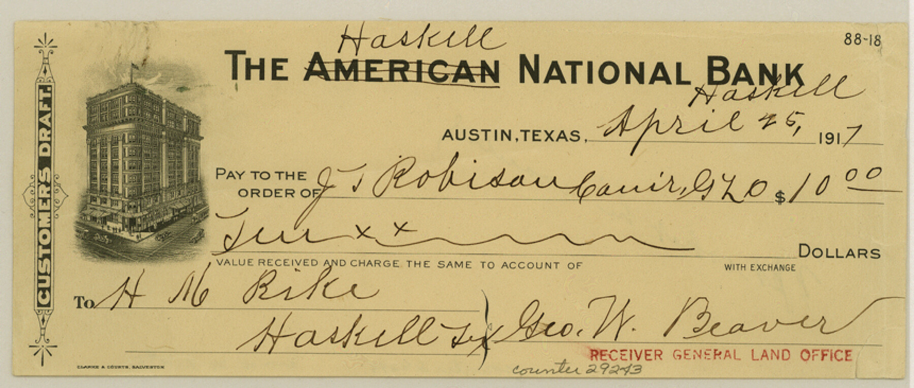
Knox County Sketch File 21
[Rejected draft for Working Sketch]
-
Map/Doc
29243
-
Collection
General Map Collection
-
Object Dates
4/25/1917 (Creation Date)
4/14/1917 (Correspondence Date)
4/27/1917 (Correspondence Date)
5/2/1917 (Correspondence Date)
-
People and Organizations
H.M. Rike (Surveyor/Engineer)
-
Counties
Knox
-
Subjects
Surveying Sketch File
-
Height x Width
3.7 x 8.6 inches
9.4 x 21.8 cm
-
Medium
multi-page, multi-format
Part of: General Map Collection
Flight Mission No. DQO-11K, Frame 21, Galveston County

Print $20.00
- Digital $50.00
Flight Mission No. DQO-11K, Frame 21, Galveston County
1952
Size 18.6 x 19.7 inches
Map/Doc 85218
Orange County Working Sketch 4

Print $20.00
- Digital $50.00
Orange County Working Sketch 4
Size 18.8 x 12.3 inches
Map/Doc 71336
Hudspeth County Rolled Sketch 18

Print $40.00
- Digital $50.00
Hudspeth County Rolled Sketch 18
1886
Size 15.7 x 105.0 inches
Map/Doc 9204
La Salle County Working Sketch 29

Print $20.00
- Digital $50.00
La Salle County Working Sketch 29
1955
Size 25.8 x 27.4 inches
Map/Doc 70330
Working Sketch Patents & Field Notes, Sabine Lake Area

Print $20.00
- Digital $50.00
Working Sketch Patents & Field Notes, Sabine Lake Area
1959
Size 30.2 x 27.0 inches
Map/Doc 2455
Map of the Hearne and Brazos Valley Railroad from Mumford to Moseley's Ferry

Print $40.00
- Digital $50.00
Map of the Hearne and Brazos Valley Railroad from Mumford to Moseley's Ferry
1892
Size 20.0 x 56.8 inches
Map/Doc 64400
Houston Ship Channel, Alexander Island to Carpenter Bayou

Print $40.00
- Digital $50.00
Houston Ship Channel, Alexander Island to Carpenter Bayou
1989
Size 35.5 x 49.4 inches
Map/Doc 69916
Culberson County Working Sketch 42

Print $40.00
- Digital $50.00
Culberson County Working Sketch 42
1970
Size 49.1 x 44.0 inches
Map/Doc 68496
Flight Mission No. BRA-8M, Frame 114, Jefferson County

Print $20.00
- Digital $50.00
Flight Mission No. BRA-8M, Frame 114, Jefferson County
1953
Size 18.6 x 22.2 inches
Map/Doc 85610
Dimmit County Working Sketch 36

Print $20.00
- Digital $50.00
Dimmit County Working Sketch 36
1962
Size 28.0 x 40.7 inches
Map/Doc 68697
2008 Official Travel Map, Texas

2008 Official Travel Map, Texas
Size 33.4 x 36.5 inches
Map/Doc 94343
DeWitt County Sketch File 11

Print $20.00
- Digital $50.00
DeWitt County Sketch File 11
1851
Size 24.5 x 35.2 inches
Map/Doc 11314
You may also like
Map of Eastland Co.

Print $20.00
- Digital $50.00
Map of Eastland Co.
1896
Size 40.0 x 42.8 inches
Map/Doc 78411
Working Sketch in Baylor and Throckmorton Cos.

Print $20.00
- Digital $50.00
Working Sketch in Baylor and Throckmorton Cos.
1890
Size 24.2 x 20.8 inches
Map/Doc 75771
Wood County Sketch File 14

Print $46.00
- Digital $50.00
Wood County Sketch File 14
1907
Size 14.3 x 8.7 inches
Map/Doc 40671
Three-Way Consolidated County Line Independent School District, Bailey and Cochran Counties, Texas

Print $20.00
- Digital $50.00
Three-Way Consolidated County Line Independent School District, Bailey and Cochran Counties, Texas
Size 34.2 x 26.8 inches
Map/Doc 92527
Calhoun County NRC Article 33.136 Sketch 2

Print $20.00
- Digital $50.00
Calhoun County NRC Article 33.136 Sketch 2
2002
Size 18.2 x 24.6 inches
Map/Doc 78653
Go Turnpike! Dallas-Fort Worth Turnpike (Verso)

Go Turnpike! Dallas-Fort Worth Turnpike (Verso)
1963
Size 11.2 x 17.2 inches
Map/Doc 94178
Outer Continental Shelf Leasing Maps (Louisiana Offshore Operations)

Print $20.00
- Digital $50.00
Outer Continental Shelf Leasing Maps (Louisiana Offshore Operations)
1955
Size 11.1 x 13.3 inches
Map/Doc 76090
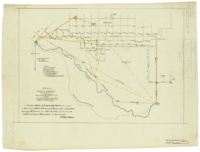
Brewster County Rolled Sketch 24A
Print $20.00
- Digital $50.00
Brewster County Rolled Sketch 24A
1910
Size 19.8 x 26.1 inches
Map/Doc 5208
Flight Mission No. DCL-6C, Frame 127, Kenedy County

Print $20.00
- Digital $50.00
Flight Mission No. DCL-6C, Frame 127, Kenedy County
1943
Size 18.5 x 22.3 inches
Map/Doc 85957
Mason County Working Sketch 11

Print $20.00
- Digital $50.00
Mason County Working Sketch 11
1951
Size 24.7 x 23.7 inches
Map/Doc 70847
Right-of-Way & Track Map, Houston and Brazos Valley Ry. Co. operated by the Houston and Brazos Valley Ry. Co.

Print $40.00
- Digital $50.00
Right-of-Way & Track Map, Houston and Brazos Valley Ry. Co. operated by the Houston and Brazos Valley Ry. Co.
1918
Size 24.7 x 56.7 inches
Map/Doc 64604
Map of the United States and Canada designed to accompany Smith's Geography for Schools

Print $20.00
- Digital $50.00
Map of the United States and Canada designed to accompany Smith's Geography for Schools
1850
Size 12.1 x 19.2 inches
Map/Doc 93884