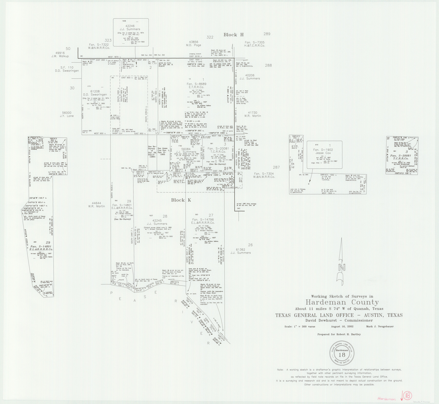
Hardeman County Working Sketch 18
-
Map/Doc
76401
-
Collection
General Map Collection
-
Object Dates
8/16/2002 (Creation Date)
-
People and Organizations
Mark Neugebauer (Draftsman)
-
Counties
Hardeman
-
Subjects
Surveying Working Sketch
-
Height x Width
33.5 x 36.5 inches
85.1 x 92.7 cm
-
Scale
1" = 300 varas
Part of: General Map Collection
Duval County Working Sketch 3

Print $40.00
- Digital $50.00
Duval County Working Sketch 3
1925
Size 59.1 x 45.0 inches
Map/Doc 76444
Galveston County Rolled Sketch 32

Print $20.00
- Digital $50.00
Galveston County Rolled Sketch 32
1979
Size 44.3 x 31.0 inches
Map/Doc 9015
Presidio County Rolled Sketch A-2A

Print $20.00
- Digital $50.00
Presidio County Rolled Sketch A-2A
Size 34.1 x 15.9 inches
Map/Doc 7406
Dimmit County Rolled Sketch 16

Print $40.00
- Digital $50.00
Dimmit County Rolled Sketch 16
1964
Size 30.5 x 48.3 inches
Map/Doc 8798
Medina County Sketch File 17

Print $40.00
- Digital $50.00
Medina County Sketch File 17
1949
Size 13.1 x 13.3 inches
Map/Doc 31480
Fractional Township No. 10 South Range No. 25 East of the Indian Meridian, Indian Territory

Print $20.00
- Digital $50.00
Fractional Township No. 10 South Range No. 25 East of the Indian Meridian, Indian Territory
1898
Size 19.2 x 24.3 inches
Map/Doc 75244
Index for Texas Railroad ROW & track maps available on microfilm at THD & Archives and Records

Print $2.00
- Digital $50.00
Index for Texas Railroad ROW & track maps available on microfilm at THD & Archives and Records
1977
Size 11.2 x 8.8 inches
Map/Doc 60756
Hardin County Rolled Sketch 21

Print $20.00
- Digital $50.00
Hardin County Rolled Sketch 21
1966
Size 18.8 x 22.7 inches
Map/Doc 6090
Map of Nacogdoches County

Print $20.00
- Digital $50.00
Map of Nacogdoches County
1881
Size 24.1 x 21.5 inches
Map/Doc 4605
Duval County Sketch File 82

Print $10.00
- Digital $50.00
Duval County Sketch File 82
1933
Size 11.3 x 8.8 inches
Map/Doc 21516
Bexar County Rolled Sketch 16
Print $20.00
- Digital $50.00
Bexar County Rolled Sketch 16
1847
Size 21.1 x 14.8 inches
Map/Doc 5141
Flight Mission No. DQN-1K, Frame 118, Calhoun County

Print $20.00
- Digital $50.00
Flight Mission No. DQN-1K, Frame 118, Calhoun County
1953
Size 18.5 x 22.2 inches
Map/Doc 84184
You may also like
Flight Mission No. DAG-21K, Frame 118, Matagorda County

Print $20.00
- Digital $50.00
Flight Mission No. DAG-21K, Frame 118, Matagorda County
1952
Size 17.5 x 16.1 inches
Map/Doc 86442
Webb County Working Sketch 26

Print $20.00
- Digital $50.00
Webb County Working Sketch 26
1931
Size 17.9 x 18.4 inches
Map/Doc 72391
Brazoria County, Texas

Print $20.00
- Digital $50.00
Brazoria County, Texas
1877
Size 24.7 x 21.7 inches
Map/Doc 425
[Blocks D and P]
![92490, [Blocks D and P], Twichell Survey Records](https://historictexasmaps.com/wmedia_w700/maps/92490-1.tif.jpg)
Print $20.00
- Digital $50.00
[Blocks D and P]
Size 41.8 x 29.1 inches
Map/Doc 92490
[Sketch showing various surveys south and along Holiday Creek]
![89979, [Sketch showing various surveys south and along Holiday Creek], Twichell Survey Records](https://historictexasmaps.com/wmedia_w700/maps/89979-1.tif.jpg)
Print $20.00
- Digital $50.00
[Sketch showing various surveys south and along Holiday Creek]
Size 36.1 x 30.1 inches
Map/Doc 89979
Erath County Sketch File 3

Print $4.00
- Digital $50.00
Erath County Sketch File 3
1853
Size 13.0 x 8.3 inches
Map/Doc 22255
General Highway Map, Fannin County, Texas

Print $20.00
General Highway Map, Fannin County, Texas
1961
Size 24.7 x 18.0 inches
Map/Doc 79464
Presidio County Working Sketch 103

Print $20.00
- Digital $50.00
Presidio County Working Sketch 103
1980
Size 47.8 x 31.2 inches
Map/Doc 71780
Flight Mission No. DIX-3P, Frame 135, Aransas County

Print $20.00
- Digital $50.00
Flight Mission No. DIX-3P, Frame 135, Aransas County
1956
Size 17.8 x 18.5 inches
Map/Doc 83765
List of surveys in Shelby County

List of surveys in Shelby County
1849
Size 13.2 x 8.2 inches
Map/Doc 62443
[Blocks T1, T2, T3, S3, A, 05, 02 and vicinity]
![92196, [Blocks T1, T2, T3, S3, A, 05, 02 and vicinity], Twichell Survey Records](https://historictexasmaps.com/wmedia_w700/maps/92196-1.tif.jpg)
Print $20.00
- Digital $50.00
[Blocks T1, T2, T3, S3, A, 05, 02 and vicinity]
Size 20.3 x 22.9 inches
Map/Doc 92196
Galveston County NRC Article 33.136 Sketch 46

Print $23.00
- Digital $50.00
Galveston County NRC Article 33.136 Sketch 46
2007
Size 24.6 x 36.0 inches
Map/Doc 87936