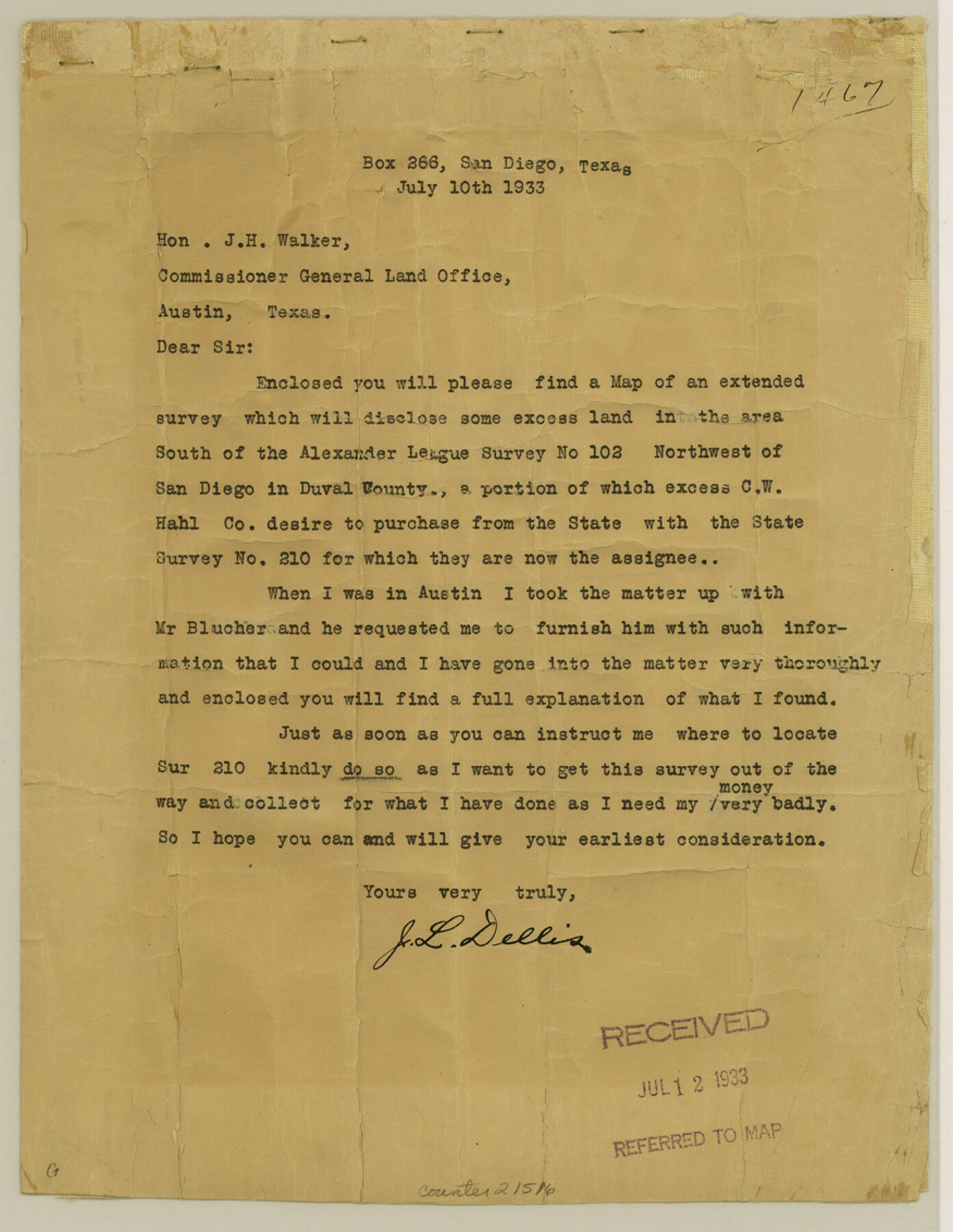
Duval County Sketch File 82
[Correspondence, field notes and sketches of section 210, J. Poitevent]
-
Map/Doc
21516
-
Collection
General Map Collection
-
Object Dates
1933 (Creation Date)
1933 (File Date)
1933/6/20 (Survey Date)
-
People and Organizations
J.L. Dellis (Surveyor/Engineer)
Sabas Longoria (Chainman)
Juan R. Garcia (Chainman)
-
Counties
Duval
-
Subjects
Surveying Sketch File
-
Height x Width
11.3 x 8.8 inches
28.7 x 22.4 cm
-
Medium
multi-page, multi-format
-
Scale
1:2000; 1:500
-
Features
Ignacio Creek
Nueces River
Part of: General Map Collection
Duval County Sketch File 35a

Print $26.00
- Digital $50.00
Duval County Sketch File 35a
Size 11.3 x 8.9 inches
Map/Doc 21371
Liberty County Sketch File 49

Print $2.00
- Digital $50.00
Liberty County Sketch File 49
1857
Size 11.8 x 8.3 inches
Map/Doc 30013
Kimble County Working Sketch 1

Print $20.00
- Digital $50.00
Kimble County Working Sketch 1
Size 14.7 x 18.3 inches
Map/Doc 70069
Brewster County Rolled Sketch 126

Print $225.00
- Digital $50.00
Brewster County Rolled Sketch 126
1908
Map/Doc 43230
Flight Mission No. DAG-26K, Frame 56, Matagorda County

Print $20.00
- Digital $50.00
Flight Mission No. DAG-26K, Frame 56, Matagorda County
1953
Size 18.6 x 22.7 inches
Map/Doc 86576
Houston County Working Sketch 10

Print $20.00
- Digital $50.00
Houston County Working Sketch 10
1953
Size 32.7 x 27.3 inches
Map/Doc 66240
Portion of States Submerged Area in Matagorda Bay

Print $20.00
- Digital $50.00
Portion of States Submerged Area in Matagorda Bay
1919
Size 16.8 x 17.2 inches
Map/Doc 2949
Fort Bend County
Print $20.00
- Digital $50.00
Fort Bend County
1865
Size 18.2 x 21.8 inches
Map/Doc 3550
Leon County Working Sketch 8

Print $20.00
- Digital $50.00
Leon County Working Sketch 8
1931
Size 28.9 x 42.8 inches
Map/Doc 70407
Old Miscellaneous File 32

Print $4.00
- Digital $50.00
Old Miscellaneous File 32
1854
Size 11.0 x 8.6 inches
Map/Doc 75751
Uvalde County Rolled Sketch 17

Print $20.00
- Digital $50.00
Uvalde County Rolled Sketch 17
Size 26.7 x 22.2 inches
Map/Doc 8101
Val Verde County Sketch File 20

Print $20.00
- Digital $50.00
Val Verde County Sketch File 20
1881
Size 26.5 x 37.2 inches
Map/Doc 12569
You may also like
Hale County Sketch File 20

Print $6.00
- Digital $50.00
Hale County Sketch File 20
Size 15.7 x 10.5 inches
Map/Doc 24753
Sterling County Rolled Sketch 15

Print $20.00
- Digital $50.00
Sterling County Rolled Sketch 15
Size 30.0 x 31.2 inches
Map/Doc 9947
Flight Mission No. BRA-3M, Frame 130, Jefferson County

Print $20.00
- Digital $50.00
Flight Mission No. BRA-3M, Frame 130, Jefferson County
1953
Size 18.6 x 22.3 inches
Map/Doc 85404
Starr County Working Sketch 25

Print $20.00
- Digital $50.00
Starr County Working Sketch 25
1988
Size 38.5 x 27.9 inches
Map/Doc 63941
Hudspeth County Working Sketch 27

Print $40.00
- Digital $50.00
Hudspeth County Working Sketch 27
1972
Size 31.0 x 51.2 inches
Map/Doc 66309
Collin County Working Sketch 1

Print $20.00
- Digital $50.00
Collin County Working Sketch 1
1921
Size 26.6 x 23.4 inches
Map/Doc 68095
Jones County Working Sketch 8

Print $20.00
- Digital $50.00
Jones County Working Sketch 8
1979
Size 25.3 x 20.9 inches
Map/Doc 66646
Moore County Working Sketch 15

Print $20.00
- Digital $50.00
Moore County Working Sketch 15
1981
Size 20.8 x 35.3 inches
Map/Doc 71197
Rio Grande Rectification Project, El Paso and Juarez Valley

Print $20.00
- Digital $50.00
Rio Grande Rectification Project, El Paso and Juarez Valley
1935
Size 10.7 x 29.4 inches
Map/Doc 60867
General Highway Map, Ellis County, Texas

Print $20.00
General Highway Map, Ellis County, Texas
1961
Size 18.2 x 24.6 inches
Map/Doc 79453
Clay County Boundary File 6

Print $2.00
- Digital $50.00
Clay County Boundary File 6
Size 8.1 x 3.5 inches
Map/Doc 51376
[Beaumont, Sour Lake and Western Ry. Right of Way and Alignment - Frisco]
![64116, [Beaumont, Sour Lake and Western Ry. Right of Way and Alignment - Frisco], General Map Collection](https://historictexasmaps.com/wmedia_w700/maps/64116.tif.jpg)
Print $20.00
- Digital $50.00
[Beaumont, Sour Lake and Western Ry. Right of Way and Alignment - Frisco]
1910
Size 20.3 x 46.1 inches
Map/Doc 64116