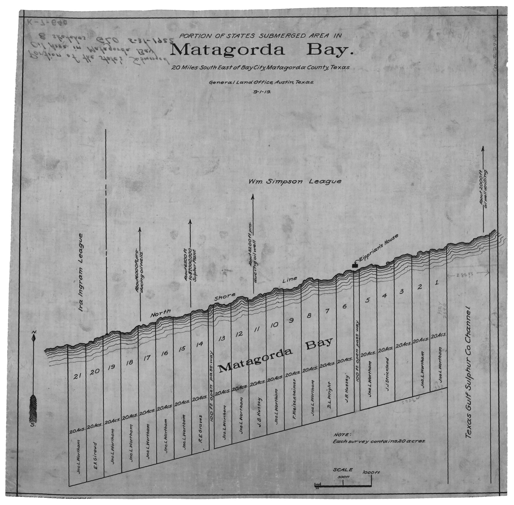
Portion of States Submerged Area in Matagorda Bay
K-7-64 (a-h)
-
Map/Doc
2949
-
Collection
General Map Collection
-
Object Dates
9/1/1919 (Creation Date)
-
Counties
Matagorda
-
Subjects
Energy Offshore Submerged Area
-
Height x Width
16.8 x 17.2 inches
42.7 x 43.7 cm
Part of: General Map Collection
Flight Mission No. CGI-4N, Frame 27, Cameron County

Print $20.00
- Digital $50.00
Flight Mission No. CGI-4N, Frame 27, Cameron County
1954
Size 18.6 x 22.5 inches
Map/Doc 84660
Zavala County Working Sketch 2

Print $20.00
- Digital $50.00
Zavala County Working Sketch 2
Size 21.5 x 16.5 inches
Map/Doc 62077
Houston Dis. Cochino Bayou

Print $2.00
- Digital $50.00
Houston Dis. Cochino Bayou
1847
Size 11.3 x 8.2 inches
Map/Doc 184
Falls County Working Sketch 5

Print $40.00
- Digital $50.00
Falls County Working Sketch 5
2008
Size 34.3 x 56.6 inches
Map/Doc 88885
Hardin County Sketch File 52

Print $6.00
- Digital $50.00
Hardin County Sketch File 52
Size 11.5 x 8.9 inches
Map/Doc 25210
Upton County Working Sketch 26

Print $20.00
- Digital $50.00
Upton County Working Sketch 26
1953
Size 29.5 x 17.6 inches
Map/Doc 69522
Fannin County Rolled Sketch 18G

Print $20.00
- Digital $50.00
Fannin County Rolled Sketch 18G
Size 27.9 x 36.0 inches
Map/Doc 5874
Montgomery County Rolled Sketch 31

Print $20.00
- Digital $50.00
Montgomery County Rolled Sketch 31
1949
Size 43.6 x 42.2 inches
Map/Doc 9539
Flight Mission No. BRA-3M, Frame 201, Jefferson County

Print $20.00
- Digital $50.00
Flight Mission No. BRA-3M, Frame 201, Jefferson County
1953
Size 18.7 x 22.5 inches
Map/Doc 85416
Zapata County Working Sketch 16

Print $20.00
- Digital $50.00
Zapata County Working Sketch 16
1969
Size 26.1 x 28.3 inches
Map/Doc 62067
Flight Mission No. BRE-1P, Frame 113, Nueces County

Print $20.00
- Digital $50.00
Flight Mission No. BRE-1P, Frame 113, Nueces County
1956
Size 18.6 x 22.6 inches
Map/Doc 86679
Brewster County Sketch File A-1

Print $8.00
- Digital $50.00
Brewster County Sketch File A-1
1911
Size 14.2 x 8.7 inches
Map/Doc 15712
You may also like
Eastland County Working Sketch 31

Print $20.00
- Digital $50.00
Eastland County Working Sketch 31
1955
Size 33.9 x 33.9 inches
Map/Doc 68812
Lamar County Sketch File 5

Print $4.00
- Digital $50.00
Lamar County Sketch File 5
1877
Size 4.8 x 8.1 inches
Map/Doc 29284
[Surveys in Austin's Colony along Hickory Creek, Hog Creek, and the Yegua River]
![195, [Surveys in Austin's Colony along Hickory Creek, Hog Creek, and the Yegua River], General Map Collection](https://historictexasmaps.com/wmedia_w700/maps/195.tif.jpg)
Print $20.00
- Digital $50.00
[Surveys in Austin's Colony along Hickory Creek, Hog Creek, and the Yegua River]
1831
Size 19.4 x 23.9 inches
Map/Doc 195
Pecos County Working Sketch 16

Print $20.00
- Digital $50.00
Pecos County Working Sketch 16
1915
Size 23.6 x 17.0 inches
Map/Doc 71486
Hockley County Working Sketch 4

Print $40.00
- Digital $50.00
Hockley County Working Sketch 4
1973
Size 38.7 x 52.3 inches
Map/Doc 66194
Galveston County NRC Article 33.136 Sketch 94

Print $72.00
Galveston County NRC Article 33.136 Sketch 94
2024
Map/Doc 97293
Galveston County Rolled Sketch JR

Print $20.00
- Digital $50.00
Galveston County Rolled Sketch JR
1938
Size 37.5 x 36.7 inches
Map/Doc 9086
Sketch showing progress of topographical work Laguna Madre and vicinity from Rainey Is. to Baffins Bay, Coast of Texas Sect. IX [and accompanying letter]
![72957, Sketch showing progress of topographical work Laguna Madre and vicinity from Rainey Is. to Baffins Bay, Coast of Texas Sect. IX [and accompanying letter], General Map Collection](https://historictexasmaps.com/wmedia_w700/maps/72957.tif.jpg)
Print $20.00
- Digital $50.00
Sketch showing progress of topographical work Laguna Madre and vicinity from Rainey Is. to Baffins Bay, Coast of Texas Sect. IX [and accompanying letter]
1880
Size 39.2 x 18.6 inches
Map/Doc 72957
Donley County Working Sketch 6

Print $20.00
- Digital $50.00
Donley County Working Sketch 6
1965
Size 34.3 x 42.2 inches
Map/Doc 68739
Flight Mission No. CRC-3R, Frame 56, Chambers County

Print $20.00
- Digital $50.00
Flight Mission No. CRC-3R, Frame 56, Chambers County
1956
Size 18.6 x 22.3 inches
Map/Doc 84828
Travis County Sketch File 7

Print $5.00
- Digital $50.00
Travis County Sketch File 7
1859
Size 9.6 x 17.0 inches
Map/Doc 38286
Val Verde County Working Sketch 57

Print $20.00
- Digital $50.00
Val Verde County Working Sketch 57
1958
Size 29.2 x 31.0 inches
Map/Doc 72192