Brewster County Sketch File A-1
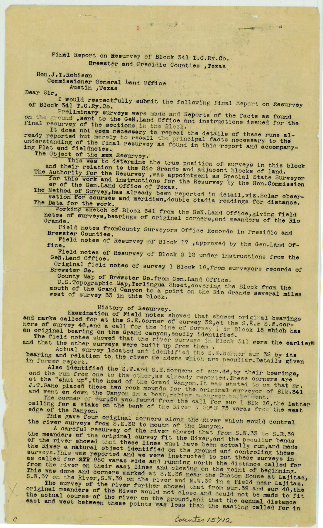
Final report on resurvey of Block 341, T. C. Ry. Co.
-
Map/Doc
15712
-
Collection
General Map Collection
-
Object Dates
1911/3/24 (Creation Date)
1911/7/29 (File Date)
-
People and Organizations
R.S. Dod (Surveyor/Engineer)
-
Counties
Brewster Presidio
-
Subjects
Surveying Sketch File
-
Height x Width
14.2 x 8.7 inches
36.1 x 22.1 cm
-
Medium
paper, print
-
Comments
See Brewster County Sketch File A (10974) for sketch.
-
Features
Grand Canyon
Rio Grande
Lajitas
Related maps
Brewster County Sketch File A

Print $40.00
- Digital $50.00
Brewster County Sketch File A
1910
Size 18.6 x 19.9 inches
Map/Doc 10974
Part of: General Map Collection
Baylor County Sketch File 1a

Print $8.00
- Digital $50.00
Baylor County Sketch File 1a
1857
Size 8.2 x 7.9 inches
Map/Doc 14144
Polk County Sketch File 35

Print $8.00
- Digital $50.00
Polk County Sketch File 35
1891
Size 14.2 x 8.7 inches
Map/Doc 34232
El Paso County Boundary File 7a

Print $20.00
- Digital $50.00
El Paso County Boundary File 7a
Size 14.2 x 8.3 inches
Map/Doc 53094
Montgomery County Working Sketch 70

Print $20.00
- Digital $50.00
Montgomery County Working Sketch 70
1973
Size 41.3 x 31.7 inches
Map/Doc 71177
Wichita County Working Sketch 25

Print $20.00
- Digital $50.00
Wichita County Working Sketch 25
1980
Size 27.1 x 27.7 inches
Map/Doc 72535
Right-of-Way & Track Map, Houston & Brazos Valley Ry. operated by Houston & Brazos Valley Ry.

Print $40.00
- Digital $50.00
Right-of-Way & Track Map, Houston & Brazos Valley Ry. operated by Houston & Brazos Valley Ry.
1918
Size 25.0 x 56.3 inches
Map/Doc 64603
[Capitol Leagues in Oldham County]
![4506, [Capitol Leagues in Oldham County], General Map Collection](https://historictexasmaps.com/wmedia_w700/maps/4506-1.tif.jpg)
Print $20.00
- Digital $50.00
[Capitol Leagues in Oldham County]
1918
Size 37.9 x 30.4 inches
Map/Doc 4506
Shelby County Rolled Sketch 4

Print $20.00
- Digital $50.00
Shelby County Rolled Sketch 4
1942
Size 36.4 x 43.2 inches
Map/Doc 9920
Archer County Sketch File 3

Print $4.00
- Digital $50.00
Archer County Sketch File 3
Size 7.5 x 8.5 inches
Map/Doc 13628
Crockett County Sketch File 51a

Print $10.00
- Digital $50.00
Crockett County Sketch File 51a
1922
Size 14.3 x 8.8 inches
Map/Doc 19812
Brazoria County Rolled Sketch 25

Print $40.00
- Digital $50.00
Brazoria County Rolled Sketch 25
1935
Size 50.8 x 33.5 inches
Map/Doc 8928
Houston County Rolled Sketch 4

Print $40.00
- Digital $50.00
Houston County Rolled Sketch 4
Size 42.2 x 52.1 inches
Map/Doc 9181
You may also like
Smith County Working Sketch 8

Print $20.00
- Digital $50.00
Smith County Working Sketch 8
1941
Size 28.9 x 22.7 inches
Map/Doc 63893
Presidio County Working Sketch 48

Print $20.00
- Digital $50.00
Presidio County Working Sketch 48
1950
Size 36.2 x 31.0 inches
Map/Doc 71725
[Cotton Belt, St. Louis Southwestern Railway of Texas, Alignment through Smith County]
![64375, [Cotton Belt, St. Louis Southwestern Railway of Texas, Alignment through Smith County], General Map Collection](https://historictexasmaps.com/wmedia_w700/maps/64375.tif.jpg)
Print $20.00
- Digital $50.00
[Cotton Belt, St. Louis Southwestern Railway of Texas, Alignment through Smith County]
1903
Size 21.3 x 28.5 inches
Map/Doc 64375
[King, Knox & Stonewall Counties]
![92916, [King, Knox & Stonewall Counties], Twichell Survey Records](https://historictexasmaps.com/wmedia_w700/maps/92916-1.tif.jpg)
Print $20.00
- Digital $50.00
[King, Knox & Stonewall Counties]
1902
Size 19.6 x 28.1 inches
Map/Doc 92916
Howard County, Texas

Print $20.00
- Digital $50.00
Howard County, Texas
1870
Size 22.7 x 17.9 inches
Map/Doc 733
Bee County Boundary File 8

Print $52.00
- Digital $50.00
Bee County Boundary File 8
Size 9.2 x 7.8 inches
Map/Doc 50464
[Pitchfork Ranch]
![4480, [Pitchfork Ranch], Maddox Collection](https://historictexasmaps.com/wmedia_w700/maps/4480.tif.jpg)
Print $20.00
- Digital $50.00
[Pitchfork Ranch]
1915
Size 20.8 x 17.2 inches
Map/Doc 4480
General Highway Map, Live Oak County, Texas

Print $20.00
General Highway Map, Live Oak County, Texas
1940
Size 18.4 x 24.8 inches
Map/Doc 79177
Rusk County Sketch File X

Print $20.00
Rusk County Sketch File X
1844
Size 18.3 x 22.4 inches
Map/Doc 12279
Polk County Sketch File 12a

Print $4.00
- Digital $50.00
Polk County Sketch File 12a
Size 6.1 x 6.4 inches
Map/Doc 34148
Loving County Rolled Sketch 2A

Print $40.00
- Digital $50.00
Loving County Rolled Sketch 2A
1952
Size 41.8 x 71.0 inches
Map/Doc 9463
Ward County Boundary File 1

Print $12.00
- Digital $50.00
Ward County Boundary File 1
Size 14.4 x 9.0 inches
Map/Doc 59667