Galveston County NRC Article 33.136 Sketch 94
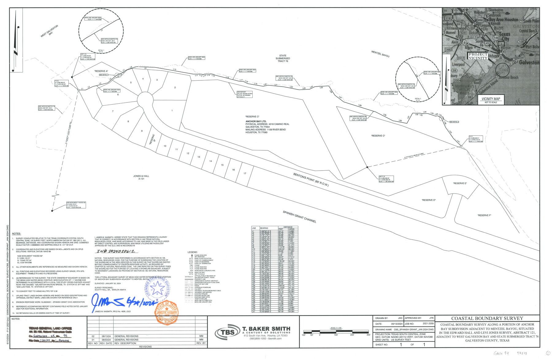
Coastal Boundary Survey along a portion of Anchor Bay Subdivision adjacent to Mentzel Bayou, situated in the Edward Hall and Levi Jones Survey, Abstract 121, adjacent to West Galveston Bay and State Submerged Tract 76
-
Map/Doc
97293
-
Collection
General Map Collection
-
Object Dates
6/24/2024 (Creation Date)
7/23/2024 (File Date)
1/30/2024 (Survey Date)
-
People and Organizations
James M. Naismith (Surveyor/Engineer)
-
Counties
Galveston
-
Subjects
Surveying CBS
-
Comments
Project: E Hall-Levi Jones-Anchor Bay Subdivision
GLO Project No.: SL20220051
Part of: General Map Collection
Webb County Working Sketch 50

Print $20.00
- Digital $50.00
Webb County Working Sketch 50
1950
Size 22.9 x 24.9 inches
Map/Doc 72415
Upton County Working Sketch 13

Print $20.00
- Digital $50.00
Upton County Working Sketch 13
1937
Size 22.6 x 43.4 inches
Map/Doc 69509
Knox County Sketch File 13

Print $10.00
- Digital $50.00
Knox County Sketch File 13
1892
Size 10.0 x 8.0 inches
Map/Doc 29230
San Jacinto County Rolled Sketch 12

Print $20.00
- Digital $50.00
San Jacinto County Rolled Sketch 12
1948
Size 24.2 x 32.5 inches
Map/Doc 7561
Jackson County

Print $20.00
- Digital $50.00
Jackson County
1840
Size 33.5 x 26.7 inches
Map/Doc 4505
Pecos County Rolled Sketch 22

Print $20.00
- Digital $50.00
Pecos County Rolled Sketch 22
1886
Size 22.4 x 36.8 inches
Map/Doc 93454
Sutton County Working Sketch 43

Print $20.00
- Digital $50.00
Sutton County Working Sketch 43
1951
Size 23.1 x 22.1 inches
Map/Doc 62386
Williamson County Working Sketch 7

Print $20.00
- Digital $50.00
Williamson County Working Sketch 7
1949
Size 30.2 x 37.3 inches
Map/Doc 72567
Shelby County Working Sketch Graphic Index

Print $20.00
- Digital $50.00
Shelby County Working Sketch Graphic Index
1945
Size 42.9 x 44.3 inches
Map/Doc 76697
Potter County Working Sketch Graphic Index

Print $20.00
- Digital $50.00
Potter County Working Sketch Graphic Index
1960
Size 42.3 x 33.1 inches
Map/Doc 76669
Map of the Straits of Florida and Gulf of Mexico

Print $20.00
- Digital $50.00
Map of the Straits of Florida and Gulf of Mexico
1851
Size 18.3 x 27.5 inches
Map/Doc 72676
Duval County Sketch File 71

Print $4.00
- Digital $50.00
Duval County Sketch File 71
1953
Size 15.2 x 9.0 inches
Map/Doc 21458
You may also like
Ector County Working Sketch 17

Print $40.00
- Digital $50.00
Ector County Working Sketch 17
1956
Size 59.9 x 24.2 inches
Map/Doc 68860
General Highway Map, Mitchell County, Texas

Print $20.00
General Highway Map, Mitchell County, Texas
1961
Size 18.1 x 24.6 inches
Map/Doc 79600
G. C. & S. F. Ry., San Saba Branch, Right of Way Map, Brady to Melvin

Print $20.00
- Digital $50.00
G. C. & S. F. Ry., San Saba Branch, Right of Way Map, Brady to Melvin
1916
Size 36.9 x 23.0 inches
Map/Doc 61422
Controlled Mosaic by Jack Amman Photogrammetric Engineers, Inc - Sheet 5

Print $20.00
- Digital $50.00
Controlled Mosaic by Jack Amman Photogrammetric Engineers, Inc - Sheet 5
1954
Size 20.8 x 24.0 inches
Map/Doc 83449
Fort Bend County Working Sketch 29

Print $20.00
- Digital $50.00
Fort Bend County Working Sketch 29
1983
Size 21.6 x 19.2 inches
Map/Doc 69235
Upton County Rolled Sketch 20

Print $40.00
- Digital $50.00
Upton County Rolled Sketch 20
1933
Size 53.0 x 36.8 inches
Map/Doc 10041
Lubbock County Lines

Print $20.00
- Digital $50.00
Lubbock County Lines
1892
Size 22.7 x 22.6 inches
Map/Doc 91308
Castro County Sketch File 12

Print $10.00
- Digital $50.00
Castro County Sketch File 12
1910
Size 11.1 x 8.6 inches
Map/Doc 17505
Wise County Sketch File 30

Print $6.00
- Digital $50.00
Wise County Sketch File 30
1876
Size 12.7 x 8.1 inches
Map/Doc 40579
Flight Mission No. DQN-7K, Frame 39, Calhoun County

Print $20.00
- Digital $50.00
Flight Mission No. DQN-7K, Frame 39, Calhoun County
1953
Size 19.0 x 22.5 inches
Map/Doc 84477
El Paso County Rolled Sketch Z53

Print $40.00
- Digital $50.00
El Paso County Rolled Sketch Z53
1915
Size 36.6 x 51.7 inches
Map/Doc 8869
J. B. McCauley Farm NW Quarter Section 30, Block A

Print $20.00
- Digital $50.00
J. B. McCauley Farm NW Quarter Section 30, Block A
Size 16.4 x 18.8 inches
Map/Doc 92315