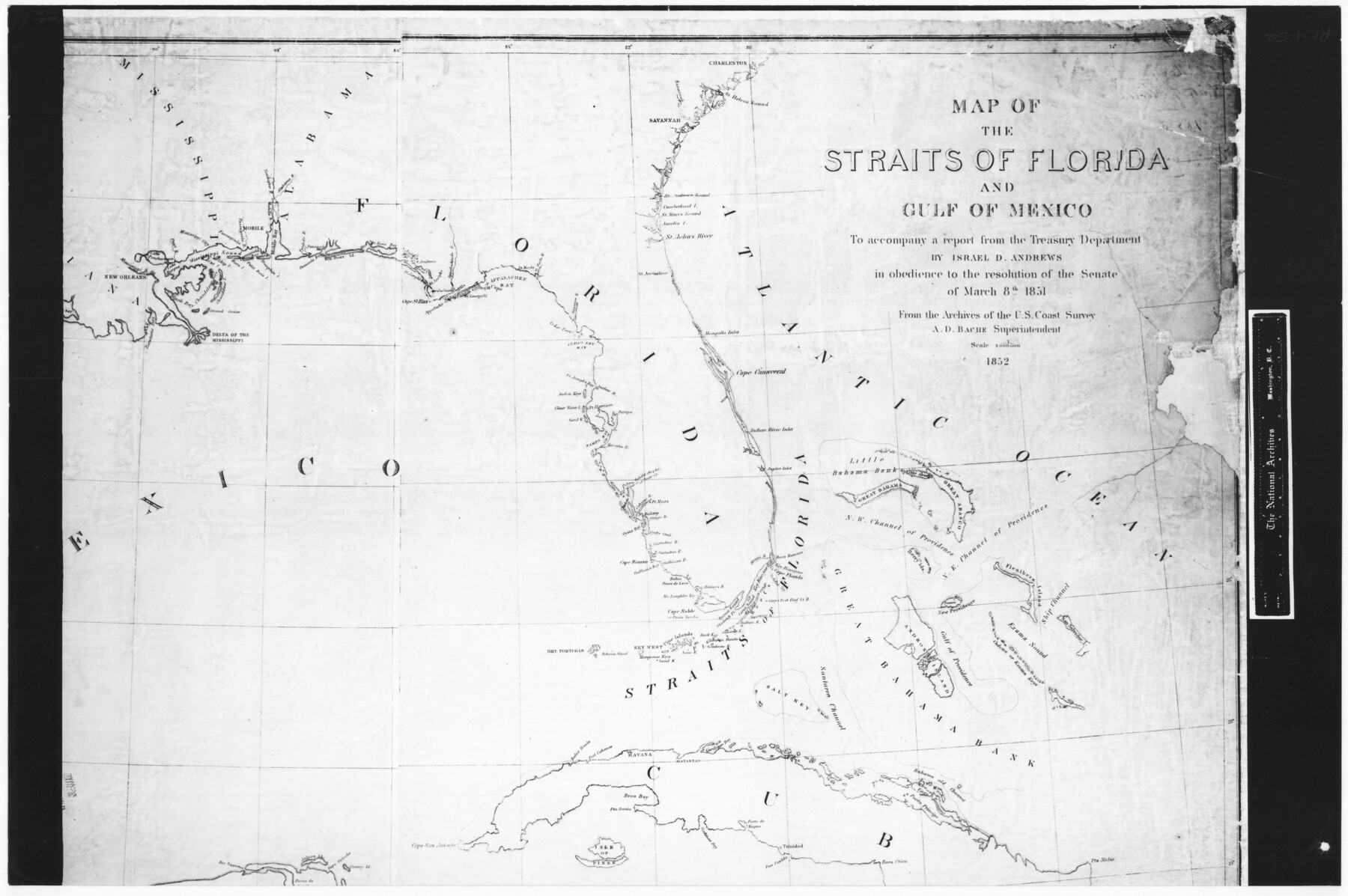
Map of the Straits of Florida and Gulf of Mexico
Map of the Straits of Florida and Gulf of Mexico to accompany a report from the Treasury Department by Israel D. Andrews in obedience to the resolution of the Senate of March 8th, 1851
RL-1-5a
-
Map/Doc
72676
-
Collection
General Map Collection
-
Object Dates
1851/3/8 (Creation Date)
-
People and Organizations
Israel D. Andrews (Author)
-
Subjects
Gulf of Mexico
-
Height x Width
18.3 x 27.5 inches
46.5 x 69.9 cm
-
Comments
B/W photostat copy from National Archives in multiple pieces.
Part of: General Map Collection
Van Zandt County Sketch File 40a

Print $4.00
- Digital $50.00
Van Zandt County Sketch File 40a
1872
Size 8.2 x 13.0 inches
Map/Doc 39488
Anderson County Working Sketch 28

Print $20.00
- Digital $50.00
Anderson County Working Sketch 28
1961
Size 23.7 x 26.5 inches
Map/Doc 67028
Jasper County Sketch File 33

Print $20.00
- Digital $50.00
Jasper County Sketch File 33
1938
Size 23.0 x 17.6 inches
Map/Doc 11854
Lynn County Rolled Sketch S

Print $20.00
- Digital $50.00
Lynn County Rolled Sketch S
Size 21.1 x 38.7 inches
Map/Doc 6654
Atascosa County Working Sketch 30

Print $20.00
- Digital $50.00
Atascosa County Working Sketch 30
1980
Size 16.4 x 20.6 inches
Map/Doc 67226
La Salle County Working Sketch 39

Print $20.00
- Digital $50.00
La Salle County Working Sketch 39
1963
Size 30.4 x 25.4 inches
Map/Doc 70340
Travis County Working Sketch 31

Print $20.00
- Digital $50.00
Travis County Working Sketch 31
1965
Size 31.2 x 35.6 inches
Map/Doc 69415
Harris County Rolled Sketch 88

Print $20.00
- Digital $50.00
Harris County Rolled Sketch 88
1936
Size 35.0 x 22.8 inches
Map/Doc 6125
Mills County Sketch File 9

Print $20.00
- Digital $50.00
Mills County Sketch File 9
Size 36.0 x 29.5 inches
Map/Doc 10544
Young County Sketch File 18

Print $10.00
- Digital $50.00
Young County Sketch File 18
1929
Size 11.5 x 8.7 inches
Map/Doc 40882
Brazos River, Brazos River Sheet 3

Print $20.00
- Digital $50.00
Brazos River, Brazos River Sheet 3
1926
Size 27.4 x 39.7 inches
Map/Doc 69667
Brewster County Working Sketch 22

Print $20.00
- Digital $50.00
Brewster County Working Sketch 22
1939
Size 18.4 x 30.7 inches
Map/Doc 67556
You may also like
Flight Mission No. DCL-6C, Frame 94, Kenedy County

Print $20.00
- Digital $50.00
Flight Mission No. DCL-6C, Frame 94, Kenedy County
1943
Size 18.6 x 22.3 inches
Map/Doc 85924
General Highway Map. Detail of Cities and Towns in Bell County, Texas [Killeen and Holland, etc.]
![79367, General Highway Map. Detail of Cities and Towns in Bell County, Texas [Killeen and Holland, etc.], Texas State Library and Archives](https://historictexasmaps.com/wmedia_w700/maps/79367.tif.jpg)
Print $20.00
General Highway Map. Detail of Cities and Towns in Bell County, Texas [Killeen and Holland, etc.]
1961
Size 18.2 x 25.0 inches
Map/Doc 79367
Flight Mission No. DQN-2K, Frame 99, Calhoun County

Print $20.00
- Digital $50.00
Flight Mission No. DQN-2K, Frame 99, Calhoun County
1953
Size 18.7 x 22.3 inches
Map/Doc 84289

Jeff Davis County Sketch File 46

Print $8.00
- Digital $50.00
Jeff Davis County Sketch File 46
1906
Size 13.5 x 8.8 inches
Map/Doc 28080
Houston County Sketch File 30

Print $4.00
- Digital $50.00
Houston County Sketch File 30
1895
Size 8.3 x 7.1 inches
Map/Doc 26806
Foard County Working Sketch 10

Print $20.00
- Digital $50.00
Foard County Working Sketch 10
1977
Size 32.0 x 43.7 inches
Map/Doc 69201
Dawson County Working Sketch 17

Print $20.00
- Digital $50.00
Dawson County Working Sketch 17
1961
Size 33.3 x 29.9 inches
Map/Doc 68561
Matagorda County Sketch File 28

Print $6.00
- Digital $50.00
Matagorda County Sketch File 28
1909
Size 14.2 x 8.8 inches
Map/Doc 30812
Starr County Sketch File 30B

Print $12.00
- Digital $50.00
Starr County Sketch File 30B
1935
Size 9.3 x 9.1 inches
Map/Doc 36954
Real County Working Sketch 70

Print $20.00
- Digital $50.00
Real County Working Sketch 70
1976
Size 32.3 x 31.8 inches
Map/Doc 71962
[Blanco County]
![3307, [Blanco County], General Map Collection](https://historictexasmaps.com/wmedia_w700/maps/3307-2.tif.jpg)
Print $20.00
- Digital $50.00
[Blanco County]
1872
Size 19.1 x 16.0 inches
Map/Doc 3307