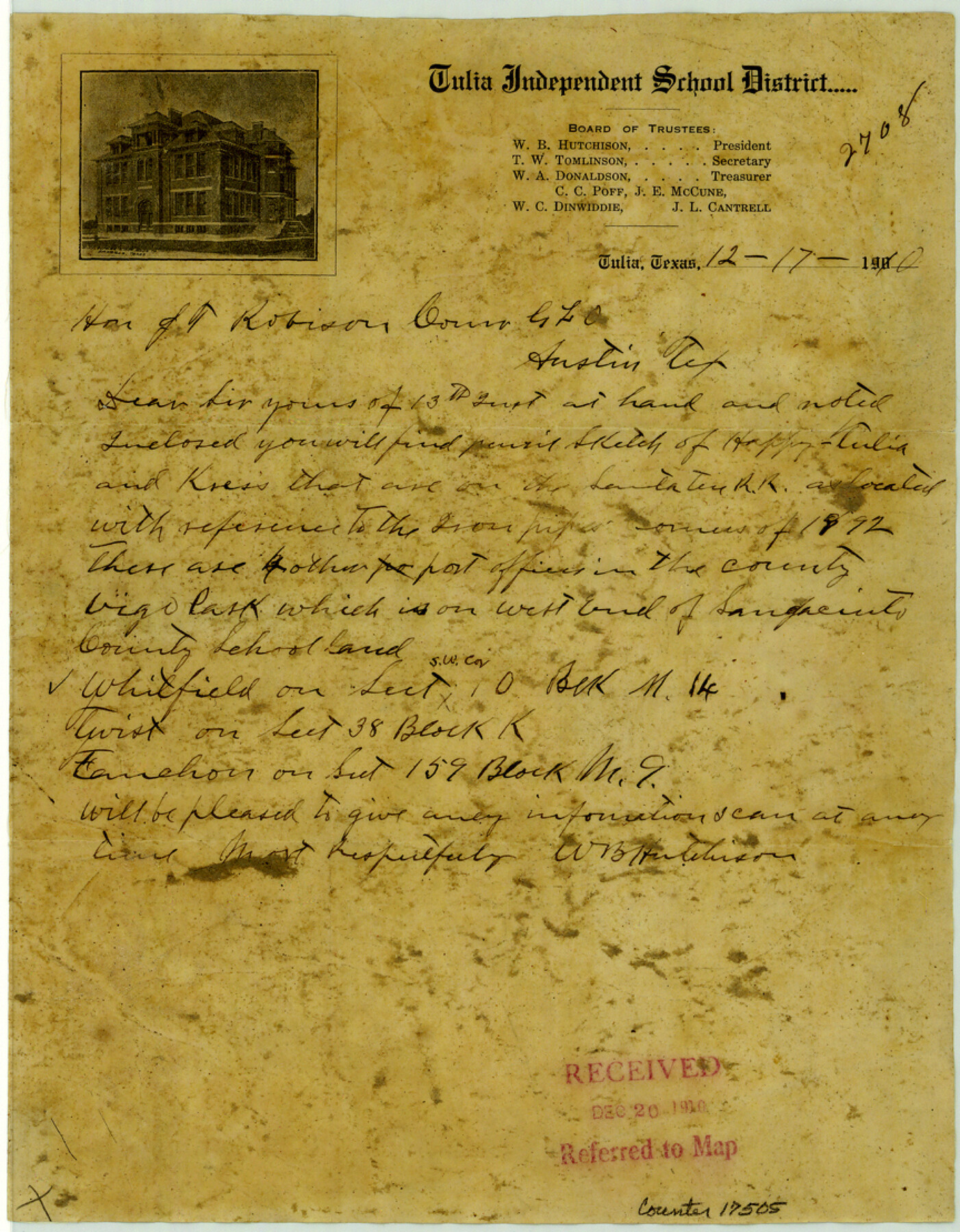
Castro County Sketch File 12
[Three sketches: one around Happy, one around Tulia, and one around Kress - all in Swisher County along a railroad]
-
Map/Doc
17505
-
Collection
General Map Collection
-
Object Dates
1910/12/20 (File Date)
1910/12/17 (Creation Date)
-
People and Organizations
W.B. Hutchison (Surveyor/Engineer)
-
Counties
Swisher
-
Subjects
Surveying Sketch File
-
Height x Width
11.1 x 8.6 inches
28.2 x 21.8 cm
-
Medium
paper, manuscript
-
Features
Middle Tule Creek
Happy Draw
Kress Depot
Part of: General Map Collection
Flight Mission No. CGI-3N, Frame 137, Cameron County

Print $20.00
- Digital $50.00
Flight Mission No. CGI-3N, Frame 137, Cameron County
1954
Size 18.6 x 22.2 inches
Map/Doc 84610
Map of Eastland Co.

Print $20.00
- Digital $50.00
Map of Eastland Co.
1889
Size 41.6 x 42.7 inches
Map/Doc 4710
Lampasas County Working Sketch 17

Print $20.00
- Digital $50.00
Lampasas County Working Sketch 17
1977
Size 24.0 x 13.2 inches
Map/Doc 70294
Gillespie County Rolled Sketch 10

Print $3.00
- Digital $50.00
Gillespie County Rolled Sketch 10
2017
Size 16.1 x 10.7 inches
Map/Doc 94413
Brazos Santiago, Texas

Print $20.00
- Digital $50.00
Brazos Santiago, Texas
1882
Size 9.0 x 16.9 inches
Map/Doc 97186
Brewster County Rolled Sketch 14

Print $20.00
- Digital $50.00
Brewster County Rolled Sketch 14
1889
Size 31.5 x 27.3 inches
Map/Doc 8469
Castro County Sketch File 3a

Print $4.00
- Digital $50.00
Castro County Sketch File 3a
1888
Size 14.1 x 8.4 inches
Map/Doc 17460
Map of the Houston & Great Northern Railroad

Print $40.00
- Digital $50.00
Map of the Houston & Great Northern Railroad
1871
Size 26.2 x 87.5 inches
Map/Doc 64471
Frio County Rolled Sketch 7

Print $20.00
- Digital $50.00
Frio County Rolled Sketch 7
Size 21.0 x 17.4 inches
Map/Doc 5918
Williamson County Sketch File 4

Print $26.00
- Digital $50.00
Williamson County Sketch File 4
1849
Size 15.9 x 10.4 inches
Map/Doc 40304
Parker County Working Sketch 20

Print $20.00
- Digital $50.00
Parker County Working Sketch 20
2005
Map/Doc 83581
Midland County

Print $20.00
- Digital $50.00
Midland County
1930
Size 45.7 x 39.6 inches
Map/Doc 66930
You may also like
[Map of Coahuila and Nuevo Leon]
![97128, [Map of Coahuila and Nuevo Leon], General Map Collection](https://historictexasmaps.com/wmedia_w700/maps/97128.tif.jpg)
Print $20.00
- Digital $50.00
[Map of Coahuila and Nuevo Leon]
1873
Size 16.8 x 11.6 inches
Map/Doc 97128
Flight Mission No. CUG-1P, Frame 28, Kleberg County

Print $20.00
- Digital $50.00
Flight Mission No. CUG-1P, Frame 28, Kleberg County
1956
Size 18.6 x 22.2 inches
Map/Doc 86118
College Heights a Subdivision of Outlots 8-9 and 62, Division B, Austin, Texas

Print $20.00
- Digital $50.00
College Heights a Subdivision of Outlots 8-9 and 62, Division B, Austin, Texas
Size 18.5 x 14.9 inches
Map/Doc 5055
Runnels County Rolled Sketch 38

Print $20.00
- Digital $50.00
Runnels County Rolled Sketch 38
1950
Size 33.9 x 46.6 inches
Map/Doc 7524

Gillespie County Sketch File 1

Print $7.00
- Digital $50.00
Gillespie County Sketch File 1
1847
Size 10.2 x 8.3 inches
Map/Doc 24124

Ward County Rolled Sketch 19

Print $20.00
- Digital $50.00
Ward County Rolled Sketch 19
1949
Size 20.5 x 26.7 inches
Map/Doc 8161
Hall County Sketch File 16

Print $20.00
- Digital $50.00
Hall County Sketch File 16
1892
Size 24.0 x 35.5 inches
Map/Doc 11608
Floyd County Sketch File 28

Print $20.00
- Digital $50.00
Floyd County Sketch File 28
Size 17.4 x 18.6 inches
Map/Doc 11487
Amistad International Reservoir on Rio Grande 89b

Print $20.00
- Digital $50.00
Amistad International Reservoir on Rio Grande 89b
1950
Size 28.4 x 40.7 inches
Map/Doc 75519
Kinney County Sketch File 12

Print $24.00
- Digital $50.00
Kinney County Sketch File 12
1885
Size 20.7 x 38.6 inches
Map/Doc 10618