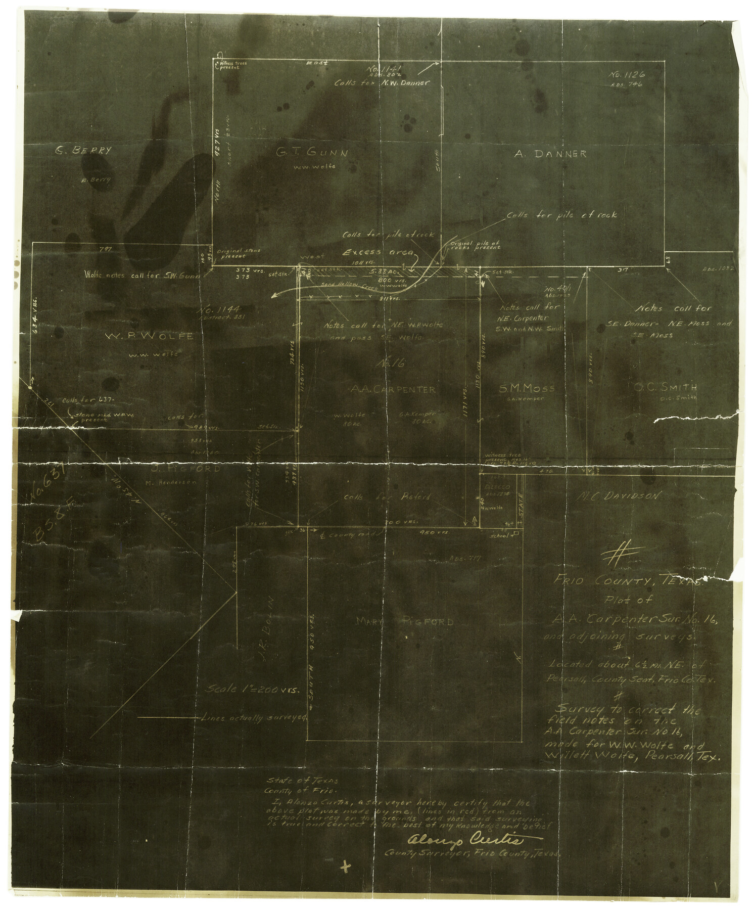
Frio County Rolled Sketch 7
Plat of A.A. Carpenter survey no. 16 and adjoining surveys
-
Map/Doc
5918
-
Collection
General Map Collection
-
Object Dates
1940/6/13 (File Date)
-
People and Organizations
Alonzo Curtis (Surveyor/Engineer)
-
Counties
Frio
-
Subjects
Cadastral Surveying Rolled Sketch
-
Height x Width
21.0 x 17.4 inches
53.3 x 44.2 cm
-
Medium
photostat
-
Scale
1" = 200 varas
Part of: General Map Collection
Right-of-Way and Track Map, Houston and Brazos Valley Ry. Co. operated by the Houston and Brazos Valley Ry. Co.
![64608, Right-of-Way and Track Map, Houston and Brazos Valley Ry. Co. operated by the Houston and Brazos Valley Ry. Co., General Map Collection](https://historictexasmaps.com/wmedia_w700/maps/64608.tif.jpg)
Print $40.00
- Digital $50.00
Right-of-Way and Track Map, Houston and Brazos Valley Ry. Co. operated by the Houston and Brazos Valley Ry. Co.
1918
Size 24.9 x 56.5 inches
Map/Doc 64608
Pecos County Working Sketch 139
![71613, Pecos County Working Sketch 139, General Map Collection](https://historictexasmaps.com/wmedia_w700/maps/71613.tif.jpg)
Print $5.00
- Digital $50.00
Pecos County Working Sketch 139
Size 31.1 x 24.9 inches
Map/Doc 71613
Hood County Rolled Sketch 8
![90084, Hood County Rolled Sketch 8, General Map Collection](https://historictexasmaps.com/wmedia_w700/maps/90084.tif.jpg)
Print $20.00
- Digital $50.00
Hood County Rolled Sketch 8
2011
Size 19.3 x 24.5 inches
Map/Doc 90084
Sketch showing progress of topographical work Laguna Madre and vicinity from Rainey Is. to Baffins Bay, Coast of Texas Sect. IX [and accompanying letter]
![72957, Sketch showing progress of topographical work Laguna Madre and vicinity from Rainey Is. to Baffins Bay, Coast of Texas Sect. IX [and accompanying letter], General Map Collection](https://historictexasmaps.com/wmedia_w700/maps/72957.tif.jpg)
Print $20.00
- Digital $50.00
Sketch showing progress of topographical work Laguna Madre and vicinity from Rainey Is. to Baffins Bay, Coast of Texas Sect. IX [and accompanying letter]
1880
Size 39.2 x 18.6 inches
Map/Doc 72957
Andrews County Sketch File 17
![12901, Andrews County Sketch File 17, General Map Collection](https://historictexasmaps.com/wmedia_w700/pdf_converted_jpg/qi_pdf_thumbnail_9034.jpg)
Print $8.00
- Digital $50.00
Andrews County Sketch File 17
Size 11.1 x 8.6 inches
Map/Doc 12901
[Surveys along the San Marcos River]
![152, [Surveys along the San Marcos River], General Map Collection](https://historictexasmaps.com/wmedia_w700/maps/152.tif.jpg)
Print $2.00
- Digital $50.00
[Surveys along the San Marcos River]
Size 9.6 x 8.0 inches
Map/Doc 152
Howard County Sketch File 5
![11794, Howard County Sketch File 5, General Map Collection](https://historictexasmaps.com/wmedia_w700/pdf_converted_jpg/qi_pdf_thumbnail_8200.jpg)
Print $3.00
- Digital $50.00
Howard County Sketch File 5
Size 20.0 x 12.8 inches
Map/Doc 11794
Map of survey of the 100th Meridian west longitude, extending from the north bank of Red River to the intersection of the Northern Boundary of the Creek or Seminole Country
![3091, Map of survey of the 100th Meridian west longitude, extending from the north bank of Red River to the intersection of the Northern Boundary of the Creek or Seminole Country, General Map Collection](https://historictexasmaps.com/wmedia_w700/maps/3091.tif.jpg)
Print $20.00
- Digital $50.00
Map of survey of the 100th Meridian west longitude, extending from the north bank of Red River to the intersection of the Northern Boundary of the Creek or Seminole Country
1859
Size 30.8 x 9.9 inches
Map/Doc 3091
Newton County Sketch File 16
![32390, Newton County Sketch File 16, General Map Collection](https://historictexasmaps.com/wmedia_w700/pdf_converted_jpg/qi_pdf_thumbnail_13296.jpg)
Print $5.00
- Digital $50.00
Newton County Sketch File 16
1880
Size 8.9 x 10.6 inches
Map/Doc 32390
San Jacinto River, Buff Lake Sheet 1/Caney Creek
![65147, San Jacinto River, Buff Lake Sheet 1/Caney Creek, General Map Collection](https://historictexasmaps.com/wmedia_w700/maps/65147.tif.jpg)
Print $20.00
- Digital $50.00
San Jacinto River, Buff Lake Sheet 1/Caney Creek
1937
Size 18.7 x 37.6 inches
Map/Doc 65147
Flight Mission No. DAG-21K, Frame 97, Matagorda County
![86426, Flight Mission No. DAG-21K, Frame 97, Matagorda County, General Map Collection](https://historictexasmaps.com/wmedia_w700/pdf_converted_jpg/qi_pdf_thumbnail_33570.jpg)
Print $20.00
- Digital $50.00
Flight Mission No. DAG-21K, Frame 97, Matagorda County
1952
Size 18.4 x 22.2 inches
Map/Doc 86426
Flight Mission No. DQO-8K, Frame 80, Galveston County
![85184, Flight Mission No. DQO-8K, Frame 80, Galveston County, General Map Collection](https://historictexasmaps.com/wmedia_w700/pdf_converted_jpg/qi_pdf_thumbnail_32392.jpg)
Print $20.00
- Digital $50.00
Flight Mission No. DQO-8K, Frame 80, Galveston County
1952
Size 18.8 x 22.5 inches
Map/Doc 85184
You may also like
Robertson V Ranch
![89756, Robertson V Ranch, Twichell Survey Records](https://historictexasmaps.com/wmedia_w700/maps/89756-1.tif.jpg)
Print $20.00
- Digital $50.00
Robertson V Ranch
Size 41.7 x 46.0 inches
Map/Doc 89756
Briscoe County Sketch File 2
![10991, Briscoe County Sketch File 2, General Map Collection](https://historictexasmaps.com/wmedia_w700/pdf_converted_jpg/qi_pdf_thumbnail_7561.jpg)
Print $40.00
- Digital $50.00
Briscoe County Sketch File 2
1880
Size 18.3 x 15.4 inches
Map/Doc 10991
Zapata County Rolled Sketch 14
![10168, Zapata County Rolled Sketch 14, General Map Collection](https://historictexasmaps.com/wmedia_w700/maps/10168-1.tif.jpg)
Print $20.00
- Digital $50.00
Zapata County Rolled Sketch 14
1925
Size 19.2 x 43.7 inches
Map/Doc 10168
Upton County Working Sketch 14
![69510, Upton County Working Sketch 14, General Map Collection](https://historictexasmaps.com/wmedia_w700/maps/69510-1.tif.jpg)
Print $20.00
- Digital $50.00
Upton County Working Sketch 14
1938
Size 14.9 x 20.9 inches
Map/Doc 69510
Flight Mission No. CUG-2P, Frame 12, Kleberg County
![86184, Flight Mission No. CUG-2P, Frame 12, Kleberg County, General Map Collection](https://historictexasmaps.com/wmedia_w700/pdf_converted_jpg/qi_pdf_thumbnail_33329.jpg)
Print $20.00
- Digital $50.00
Flight Mission No. CUG-2P, Frame 12, Kleberg County
1956
Size 18.6 x 22.1 inches
Map/Doc 86184
Glasscock County Working Sketch 9
![63182, Glasscock County Working Sketch 9, General Map Collection](https://historictexasmaps.com/wmedia_w700/maps/63182.tif.jpg)
Print $40.00
- Digital $50.00
Glasscock County Working Sketch 9
Size 77.9 x 25.5 inches
Map/Doc 63182
Layout of the porciones as described in the Visita General of Laredo, 1767
![94042, Layout of the porciones as described in the Visita General of Laredo, 1767, General Map Collection](https://historictexasmaps.com/wmedia_w700/pdf_converted_jpg/qi_pdf_thumbnail_65058.jpg)
Layout of the porciones as described in the Visita General of Laredo, 1767
2009
Size 11.0 x 8.5 inches
Map/Doc 94042
Hamilton County Sketch File 15
![24941, Hamilton County Sketch File 15, General Map Collection](https://historictexasmaps.com/wmedia_w700/pdf_converted_jpg/qi_pdf_thumbnail_11593.jpg)
Print $2.00
- Digital $50.00
Hamilton County Sketch File 15
1882
Size 8.0 x 11.8 inches
Map/Doc 24941
Webb County Working Sketch 51
![72416, Webb County Working Sketch 51, General Map Collection](https://historictexasmaps.com/wmedia_w700/maps/72416.tif.jpg)
Print $40.00
- Digital $50.00
Webb County Working Sketch 51
Size 70.2 x 32.9 inches
Map/Doc 72416
Nueces County Rolled Sketch 34
![9601, Nueces County Rolled Sketch 34, General Map Collection](https://historictexasmaps.com/wmedia_w700/maps/9601-1.tif.jpg)
Print $20.00
- Digital $50.00
Nueces County Rolled Sketch 34
1951
Size 47.9 x 37.5 inches
Map/Doc 9601
Pecos County Working Sketch 37
![71509, Pecos County Working Sketch 37, General Map Collection](https://historictexasmaps.com/wmedia_w700/maps/71509.tif.jpg)
Print $20.00
- Digital $50.00
Pecos County Working Sketch 37
Size 30.0 x 43.0 inches
Map/Doc 71509
Waller County Sketch File 2
![39570, Waller County Sketch File 2, General Map Collection](https://historictexasmaps.com/wmedia_w700/pdf_converted_jpg/qi_pdf_thumbnail_14902.jpg)
Print $52.00
- Digital $50.00
Waller County Sketch File 2
Size 13.3 x 9.0 inches
Map/Doc 39570