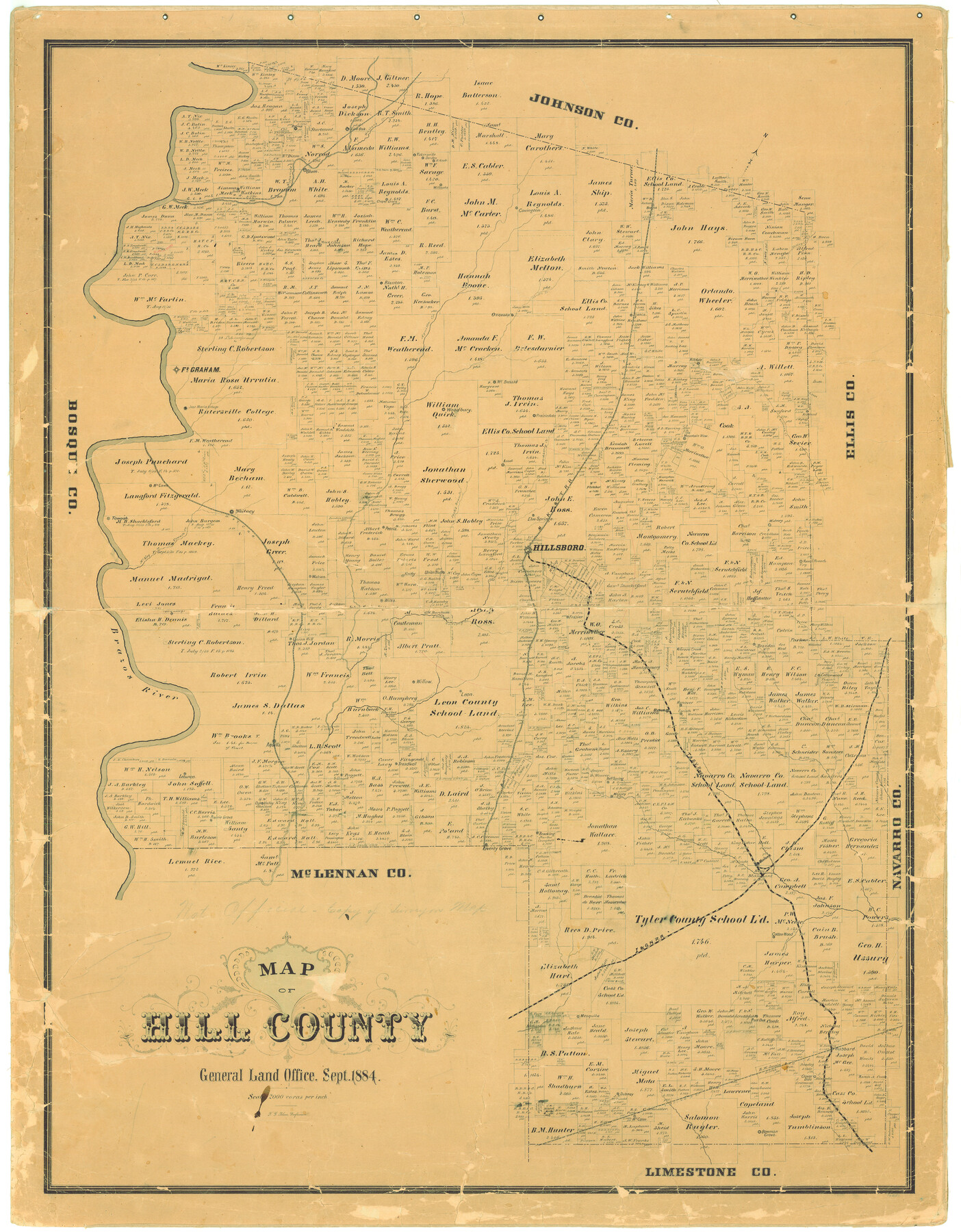
Map of Hill County
-
Map/Doc
16851
-
Collection
General Map Collection
-
Object Dates
1884 (Creation Date)
-
People and Organizations
Texas General Land Office (Publisher)
F.G. Blau (Compiler)
F.G. Blau (Draftsman)
-
Counties
Hill
-
Subjects
County
-
Height x Width
47.2 x 36.8 inches
119.9 x 93.5 cm
-
Comments
Help Save Texas History - Adopt Me!
-
Features
Brazos River
B. Knob
Massey Post Office
Bell Spring
T&BV
Cottonwood
Corinth
Hanover
Bynum
Leon
Derden
Treadwell
Watson
Union Hill
Rocky
Wilks
Union Bluff
Hackberry Creek
Frazier
Grove Creek
Brandon
Hamil Branch
Cotton Wood
Clover Dale
Bowman Grove
T&SLNG
Mount Calm
Mount Calm
Dabney
Mesquite
Post Oak
Hubbard
I&GN
Midway
Cottonwood Creek
Willow
Malone
Brooking
Liverty Grove
Prairie Grove
Lebanon
Oak Valley
Aquilla
South Chapell
Hodges
Woodbury
Jose Maria Village
Yatersville
Fort Graham
Blanton
Aguilla Creek
Osceola
Johnson Creek
Itasca
Valley Creek
McDonald
Covington
Wilbanks
Chapel Grove
Rock Creek
GC&SF
Brock
Nolands River
Belnap
Live Oak
Blum
Arnot
Elm Springs
Hillsboro
Jack's Branch [of Hackberry Creek]
Peoria
Whitney
H&TC
Towash Creek
McKay Creek
Towash
McCown
Mustang Creek
Firles
MK&T
Mountain View
Mill Creek
Richland
Richland Creek
Hilldale
MPRR
Prairiedale
Part of: General Map Collection
Denton County Rolled Sketch 3

Print $20.00
- Digital $50.00
Denton County Rolled Sketch 3
1959
Size 39.1 x 23.9 inches
Map/Doc 5700
Burleson County Sketch File 3

Print $4.00
- Digital $50.00
Burleson County Sketch File 3
1848
Size 6.4 x 7.4 inches
Map/Doc 16647
Menard County Rolled Sketch 17

Print $20.00
- Digital $50.00
Menard County Rolled Sketch 17
1950
Size 23.2 x 26.3 inches
Map/Doc 6763
Map of Tyler County

Print $20.00
- Digital $50.00
Map of Tyler County
1897
Size 42.2 x 39.2 inches
Map/Doc 63081
General Chart of the Coast No. XVI - Gulf Coast from Galveston to the Rio Grande

Print $20.00
- Digital $50.00
General Chart of the Coast No. XVI - Gulf Coast from Galveston to the Rio Grande
1883
Size 26.8 x 18.2 inches
Map/Doc 72736
Randall County Rolled Sketch 8

Print $20.00
- Digital $50.00
Randall County Rolled Sketch 8
Size 25.7 x 35.6 inches
Map/Doc 7428
Wilson County Working Sketch 10

Print $20.00
- Digital $50.00
Wilson County Working Sketch 10
1980
Size 16.6 x 11.7 inches
Map/Doc 72590
Real County Rolled Sketch 3

Print $20.00
- Digital $50.00
Real County Rolled Sketch 3
1955
Size 14.6 x 23.3 inches
Map/Doc 7453
Hutchinson County Rolled Sketch 44-10

Print $20.00
- Digital $50.00
Hutchinson County Rolled Sketch 44-10
2002
Size 24.0 x 36.0 inches
Map/Doc 77546
Map of Hall County

Print $20.00
- Digital $50.00
Map of Hall County
1895
Size 25.2 x 20.2 inches
Map/Doc 3619
Glasscock County Rolled Sketch 14

Print $20.00
- Digital $50.00
Glasscock County Rolled Sketch 14
1957
Size 29.0 x 26.3 inches
Map/Doc 6020
Upton County Rolled Sketch 59

Print $40.00
- Digital $50.00
Upton County Rolled Sketch 59
Size 37.8 x 48.4 inches
Map/Doc 10062
You may also like
Wichita County Rolled Sketch 20

Print $45.00
- Digital $50.00
Wichita County Rolled Sketch 20
Size 11.0 x 14.5 inches
Map/Doc 49546
Map of Fannin County

Print $40.00
- Digital $50.00
Map of Fannin County
1841
Size 50.4 x 46.8 inches
Map/Doc 7821
San Jacinto River and Tributaries, Texas - Survey of 1939

Print $20.00
- Digital $50.00
San Jacinto River and Tributaries, Texas - Survey of 1939
1939
Size 27.7 x 40.5 inches
Map/Doc 60310
Presidio County Rolled Sketch 7

Print $40.00
- Digital $50.00
Presidio County Rolled Sketch 7
1875
Size 37.5 x 53.8 inches
Map/Doc 9762
[Right of Way & Track Map, The Texas & Pacific Ry. Co. Main Line]
![64666, [Right of Way & Track Map, The Texas & Pacific Ry. Co. Main Line], General Map Collection](https://historictexasmaps.com/wmedia_w700/maps/64666.tif.jpg)
Print $20.00
- Digital $50.00
[Right of Way & Track Map, The Texas & Pacific Ry. Co. Main Line]
Size 11.0 x 18.5 inches
Map/Doc 64666
Galveston County Sketch File 34a

Print $20.00
- Digital $50.00
Galveston County Sketch File 34a
Size 11.4 x 20.3 inches
Map/Doc 11537
Map of Texas Compiled from surveys recorded in the General Land Office

Print $20.00
Map of Texas Compiled from surveys recorded in the General Land Office
1851
Size 31.4 x 25.3 inches
Map/Doc 76209
Current Miscellaneous File 120

Print $14.00
- Digital $50.00
Current Miscellaneous File 120
Size 8.5 x 11.0 inches
Map/Doc 88754
Maps & Lists Showing Prison Lands (Oil & Gas) Leased as of June 1955

Digital $50.00
Maps & Lists Showing Prison Lands (Oil & Gas) Leased as of June 1955
Size 11.4 x 7.0 inches
Map/Doc 62864
Plat Showing Survey made for J. M. Teague, Jr. Gaines County, Texas

Print $20.00
- Digital $50.00
Plat Showing Survey made for J. M. Teague, Jr. Gaines County, Texas
1956
Size 12.7 x 18.7 inches
Map/Doc 92672
University Lands Blocks 21 to 26, Pecos County, Texas

Print $20.00
- Digital $50.00
University Lands Blocks 21 to 26, Pecos County, Texas
1939
Size 46.1 x 36.8 inches
Map/Doc 2416
Flight Mission No. DAG-21K, Frame 31, Matagorda County

Print $20.00
- Digital $50.00
Flight Mission No. DAG-21K, Frame 31, Matagorda County
1952
Size 18.7 x 22.4 inches
Map/Doc 86398