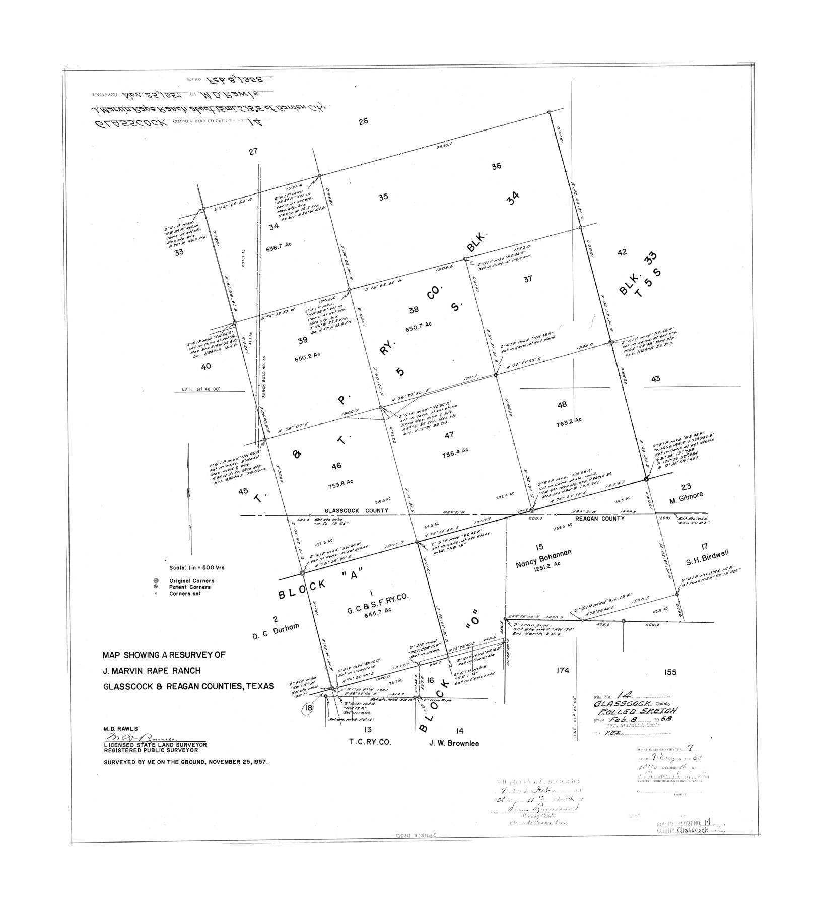
Glasscock County Rolled Sketch 14
Map showing a resurvey of J. Marvin Rape Ranch, Glasscock & Reagan Counties, Texas
-
Map/Doc
6020
-
Collection
General Map Collection
-
Object Dates
1957/11/25 (Creation Date)
1958/2/8 (File Date)
-
People and Organizations
M.D. Rawls (Surveyor/Engineer)
-
Counties
Glasscock Reagan
-
Subjects
Surveying Rolled Sketch
-
Height x Width
29.0 x 26.3 inches
73.7 x 66.8 cm
-
Scale
1" = 500 varas
Part of: General Map Collection
[Sketch for Mineral Application 24072, San Jacinto River]
![65598, [Sketch for Mineral Application 24072, San Jacinto River], General Map Collection](https://historictexasmaps.com/wmedia_w700/maps/65598.tif.jpg)
Print $20.00
- Digital $50.00
[Sketch for Mineral Application 24072, San Jacinto River]
1929
Size 24.6 x 18.3 inches
Map/Doc 65598
Johnson County Sketch File 5

Print $20.00
- Digital $50.00
Johnson County Sketch File 5
1874
Size 33.3 x 14.3 inches
Map/Doc 11890
Cochran County Rolled Sketch 6

Print $20.00
- Digital $50.00
Cochran County Rolled Sketch 6
2025
Size 20.5 x 28.2 inches
Map/Doc 97417
San Patricio County Rolled Sketch 25

Print $40.00
- Digital $50.00
San Patricio County Rolled Sketch 25
1925
Size 37.2 x 54.1 inches
Map/Doc 9887
Map of Nacogdoches County

Print $20.00
- Digital $50.00
Map of Nacogdoches County
1881
Size 24.5 x 21.8 inches
Map/Doc 4604
Parker County Rolled Sketch 4

Print $20.00
- Digital $50.00
Parker County Rolled Sketch 4
Size 28.0 x 34.1 inches
Map/Doc 7205
Bexar County Rolled Sketch 4B

Print $20.00
- Digital $50.00
Bexar County Rolled Sketch 4B
1989
Size 24.3 x 36.7 inches
Map/Doc 5139
Flight Mission No. CRC-5R, Frame 25, Chambers County

Print $20.00
- Digital $50.00
Flight Mission No. CRC-5R, Frame 25, Chambers County
1956
Size 18.9 x 22.4 inches
Map/Doc 84947
Map of Galveston Harbor and City

Print $40.00
- Digital $50.00
Map of Galveston Harbor and City
1850
Size 31.0 x 52.0 inches
Map/Doc 69856
Van Zandt County Sketch File 6

Print $4.00
- Digital $50.00
Van Zandt County Sketch File 6
1848
Size 9.7 x 7.9 inches
Map/Doc 39373
Sketches of Surveys in Montgomery Co.

Print $2.00
- Digital $50.00
Sketches of Surveys in Montgomery Co.
1845
Size 10.2 x 8.0 inches
Map/Doc 69731
Map of the East Part of Tom Green County

Print $40.00
- Digital $50.00
Map of the East Part of Tom Green County
1894
Size 45.9 x 49.4 inches
Map/Doc 63071
You may also like
Cooke County Sketch File 13

Print $20.00
- Digital $50.00
Cooke County Sketch File 13
1859
Size 27.1 x 19.0 inches
Map/Doc 11171
Sutton County Sketch File 46

Print $4.00
- Digital $50.00
Sutton County Sketch File 46
1939
Size 11.3 x 8.8 inches
Map/Doc 37517
Plan of Brooklyn

Print $20.00
- Digital $50.00
Plan of Brooklyn
1909
Size 42.7 x 31.5 inches
Map/Doc 2192
Map of the State of Coahuila and Texas

Print $20.00
- Digital $50.00
Map of the State of Coahuila and Texas
1834
Size 13.2 x 14.7 inches
Map/Doc 93848
[Map of Coahuila and Nuevo Leon]
![97128, [Map of Coahuila and Nuevo Leon], General Map Collection](https://historictexasmaps.com/wmedia_w700/maps/97128.tif.jpg)
Print $20.00
- Digital $50.00
[Map of Coahuila and Nuevo Leon]
1873
Size 16.8 x 11.6 inches
Map/Doc 97128

Menard County Working Sketch 26

Print $20.00
- Digital $50.00
Menard County Working Sketch 26
1961
Size 28.6 x 36.1 inches
Map/Doc 70973

Wharton County Working Sketch 12

Print $20.00
- Digital $50.00
Wharton County Working Sketch 12
1970
Size 22.3 x 30.3 inches
Map/Doc 72476
Right of Way and Track Map of The Wichita Falls & Southern Railroad Company

Print $40.00
- Digital $50.00
Right of Way and Track Map of The Wichita Falls & Southern Railroad Company
1942
Size 24.6 x 56.1 inches
Map/Doc 64518
[Sketch of sections 59-64, I. & G. N. Block 1 and part of Block Z]
![93167, [Sketch of sections 59-64, I. & G. N. Block 1 and part of Block Z], Twichell Survey Records](https://historictexasmaps.com/wmedia_w700/maps/93167-1.tif.jpg)
Print $40.00
- Digital $50.00
[Sketch of sections 59-64, I. & G. N. Block 1 and part of Block Z]
Size 74.8 x 43.5 inches
Map/Doc 93167
Glasscock County Sketch File 25

Print $20.00
- Digital $50.00
Glasscock County Sketch File 25
1951
Size 28.8 x 20.6 inches
Map/Doc 11566