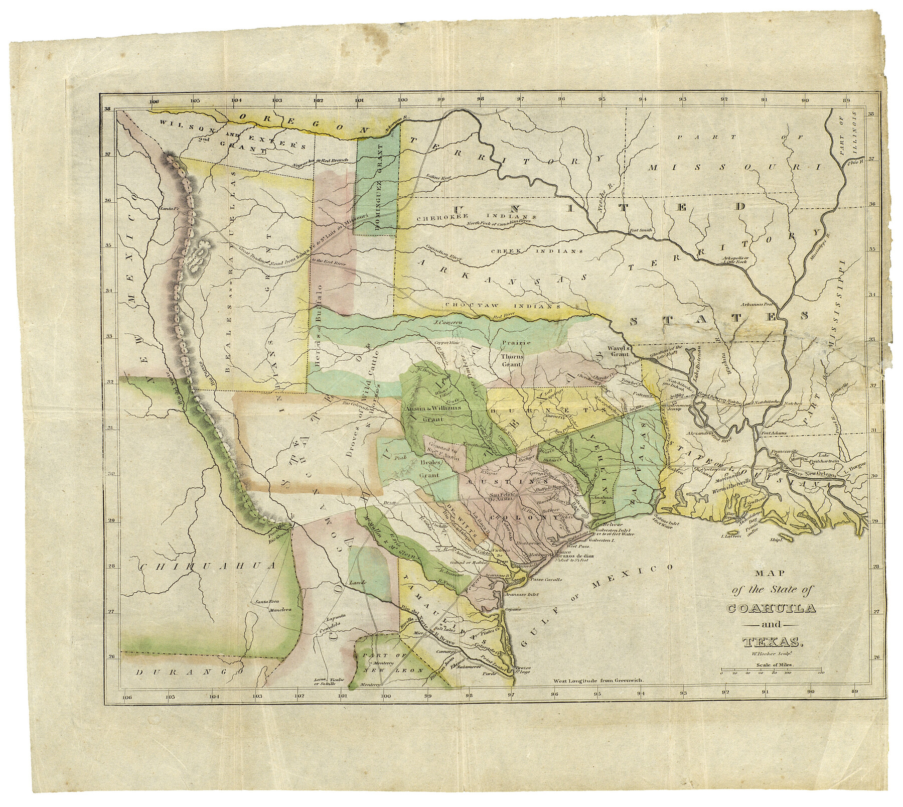
Map of the State of Coahuila and Texas
-
Map/Doc
93848
-
Collection
Holcomb Map Collection
-
Object Dates
1834 (Creation Date)
-
People and Organizations
W. Hooker (Printer)
-
Subjects
Mexican Texas
-
Height x Width
13.2 x 14.7 inches
33.5 x 37.3 cm
-
Comments
From the book: "A Visit to Texas: Being The Journal of a Traveler Through Those Parts Most Interesting to American Settlers. With Descriptions of Scenery, Habits, & c. &c." Courtesy of Frank and Carol Holcomb.
Part of: Holcomb Map Collection
[Map of the Texas & Pacific Railway and connections]
![95414, [Map of the Texas & Pacific Railway and connections], Holcomb Digital Map Collection](https://historictexasmaps.com/wmedia_w700/maps/95414.tif.jpg)
Print $20.00
- Digital $50.00
[Map of the Texas & Pacific Railway and connections]
1902
Size 18.0 x 37.0 inches
Map/Doc 95414
Mexico and Internal Provinces

Print $20.00
- Digital $50.00
Mexico and Internal Provinces
1829
Size 13.6 x 15.3 inches
Map/Doc 96971
Map of Texas and the Countries Adjacent compiled in the Bureau of the Corps of Topographical Engineers from the Best Authorities

Print $2.00
- Digital $50.00
Map of Texas and the Countries Adjacent compiled in the Bureau of the Corps of Topographical Engineers from the Best Authorities
1844
Size 8.1 x 5.0 inches
Map/Doc 93868
Map of the Colonization Grants to Zavala, Vehlein & Burnet in Texas, belonging to the Galveston Bay & Texas Land Co.

Print $20.00
- Digital $50.00
Map of the Colonization Grants to Zavala, Vehlein & Burnet in Texas, belonging to the Galveston Bay & Texas Land Co.
1835
Size 10.7 x 12.7 inches
Map/Doc 93851
A Map of Louisiana and Mexico

Print $20.00
- Digital $50.00
A Map of Louisiana and Mexico
1820
Size 43.8 x 32.9 inches
Map/Doc 94945
Central Europe designed to accompany Smith's Geography for Schools

Print $20.00
- Digital $50.00
Central Europe designed to accompany Smith's Geography for Schools
1850
Size 12.1 x 9.8 inches
Map/Doc 93895
Map of Mexico, including Yucatan & Upper California, exhibiting the chief cities and towns, the principal travelling routes &c.

Print $20.00
- Digital $50.00
Map of Mexico, including Yucatan & Upper California, exhibiting the chief cities and towns, the principal travelling routes &c.
1846
Size 18.3 x 26.1 inches
Map/Doc 93871
Colton's New Map of the State of Texas, the Indian Territory and adjoining portions of New Mexico, Louisiana and Arkansas

Print $20.00
- Digital $50.00
Colton's New Map of the State of Texas, the Indian Territory and adjoining portions of New Mexico, Louisiana and Arkansas
1882
Size 32.8 x 37.3 inches
Map/Doc 93909
Bird's Eye View of the City of Houston, Texas

Print $20.00
- Digital $50.00
Bird's Eye View of the City of Houston, Texas
1873
Size 25.2 x 31.5 inches
Map/Doc 93908
A New Map of Texas, Oregon and California with the regions adjoining, compiled from the most recent authorities

Print $20.00
- Digital $50.00
A New Map of Texas, Oregon and California with the regions adjoining, compiled from the most recent authorities
1846
Size 23.2 x 21.2 inches
Map/Doc 93872
A New Map of Texas with the Contiguous American & Mexican States

Print $20.00
- Digital $50.00
A New Map of Texas with the Contiguous American & Mexican States
1835
Size 12.9 x 15.8 inches
Map/Doc 93853
Trace d'une partie Chemin de Fer de Galveston à Houston et Henderson, Texas, Etats unis d'Amérique

Print $20.00
- Digital $50.00
Trace d'une partie Chemin de Fer de Galveston à Houston et Henderson, Texas, Etats unis d'Amérique
1857
Size 17.1 x 21.8 inches
Map/Doc 93905
You may also like
[H. P. Fleming, J. E. Fitzgerald, J. R. Scott and surrounding surveys]
![90954, [H. P. Fleming, J. E. Fitzgerald, J. R. Scott and surrounding surveys], Twichell Survey Records](https://historictexasmaps.com/wmedia_w700/maps/90954-1.tif.jpg)
Print $20.00
- Digital $50.00
[H. P. Fleming, J. E. Fitzgerald, J. R. Scott and surrounding surveys]
Size 19.7 x 12.9 inches
Map/Doc 90954
Sterling County Rolled Sketch 15

Print $20.00
- Digital $50.00
Sterling County Rolled Sketch 15
Size 30.0 x 31.2 inches
Map/Doc 9947
Webb County Rolled Sketch 57

Print $20.00
- Digital $50.00
Webb County Rolled Sketch 57
Size 23.5 x 32.2 inches
Map/Doc 8209
Gonzales County Sketch File 5

Print $16.00
- Digital $50.00
Gonzales County Sketch File 5
1879
Size 10.0 x 8.1 inches
Map/Doc 24377
Bell County, Texas

Print $20.00
- Digital $50.00
Bell County, Texas
1879
Size 23.7 x 29.0 inches
Map/Doc 516
Refugio County Boundary File 6a

Print $20.00
- Digital $50.00
Refugio County Boundary File 6a
Size 14.4 x 9.0 inches
Map/Doc 58262
Flight Mission No. DQN-2K, Frame 135, Calhoun County

Print $20.00
- Digital $50.00
Flight Mission No. DQN-2K, Frame 135, Calhoun County
1953
Size 19.0 x 22.5 inches
Map/Doc 84304
Colonial Texas. 1822 to 1834.

Print $20.00
- Digital $50.00
Colonial Texas. 1822 to 1834.
1897
Size 12.8 x 16.3 inches
Map/Doc 93410
Trinity River, Rockwall Sheet/East Fork of Trinity River

Print $4.00
- Digital $50.00
Trinity River, Rockwall Sheet/East Fork of Trinity River
1936
Size 29.6 x 22.9 inches
Map/Doc 65193
Flight Mission No. DQN-5K, Frame 74, Calhoun County

Print $20.00
- Digital $50.00
Flight Mission No. DQN-5K, Frame 74, Calhoun County
1953
Size 18.5 x 22.2 inches
Map/Doc 84407

[Surveys in Cherokee County]
![251, [Surveys in Cherokee County], General Map Collection](https://historictexasmaps.com/wmedia_w700/maps/251.tif.jpg)
Print $2.00
- Digital $50.00
[Surveys in Cherokee County]
Size 8.0 x 5.6 inches
Map/Doc 251