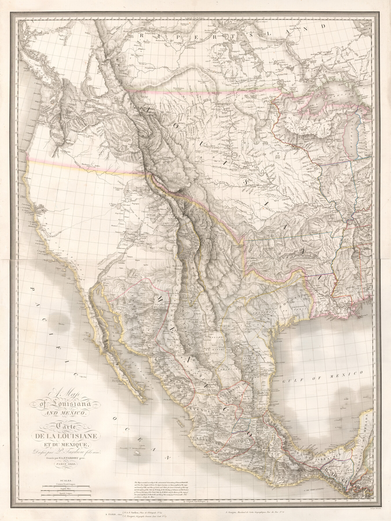
A Map of Louisiana and Mexico
Carte de la Louisiane et du Mexique
-
Map/Doc
94945
-
Collection
Holcomb Map Collection
-
Object Dates
1820 (Creation Date)
-
People and Organizations
P.A. Tardieu (Publisher)
P.A.F. Tardieu (Printer)
P.A. Tardieu (Draftsman)
P.A.F. Tardieu (Engraver)
-
Subjects
Mexico Spanish Texas United States
-
Height x Width
43.8 x 32.9 inches
111.3 x 83.6 cm
-
Comments
Courtesy of Frank and Carol Holcomb.
Part of: Holcomb Map Collection
Map and Description of Texas, containing sketches of its history, geology, geography and statistics: with concise statements, relative to the soil, climate, productions, facilities of transportation, population of the country;

Print $324.00
- Digital $50.00
Map and Description of Texas, containing sketches of its history, geology, geography and statistics: with concise statements, relative to the soil, climate, productions, facilities of transportation, population of the country;
1840
Size 6.1 x 4.1 inches
Map/Doc 93861
Fredonia or the United States of North-America; including also Cabotia, or the Canadian Provinces; the Western Territory to the Pacific Ocean; and the Northern Part of the Mexican States

Print $20.00
- Digital $50.00
Fredonia or the United States of North-America; including also Cabotia, or the Canadian Provinces; the Western Territory to the Pacific Ocean; and the Northern Part of the Mexican States
1848
Size 26.8 x 39.9 inches
Map/Doc 93879
Map of North America designed to accompany Smith's Geography for Schools

Print $20.00
- Digital $50.00
Map of North America designed to accompany Smith's Geography for Schools
1850
Size 12.0 x 9.9 inches
Map/Doc 93883
Map of Texas compiled from surveys at the Land Office of Texas

Print $20.00
- Digital $50.00
Map of Texas compiled from surveys at the Land Office of Texas
1851
Size 26.7 x 19.1 inches
Map/Doc 96431
Pressler's Map of the State of Texas

Print $40.00
- Digital $50.00
Pressler's Map of the State of Texas
1862
Size 48.0 x 52.7 inches
Map/Doc 95714
A New, Plaine, and Exact map of America : described by N.I. Visscher, and don into English, enlarged, and corrected, according to I. Blaeu, with the habits of the countries, and the manner of the cheife Citties, the like never before

Print $20.00
- Digital $50.00
A New, Plaine, and Exact map of America : described by N.I. Visscher, and don into English, enlarged, and corrected, according to I. Blaeu, with the habits of the countries, and the manner of the cheife Citties, the like never before
1658
Size 16.4 x 20.9 inches
Map/Doc 96787
L'Amerique divisée en ses principales parties où sont distingués les uns des autres les estats selon quils appartiennent presentement aux differents souverains de l'Europe

Print $20.00
- Digital $50.00
L'Amerique divisée en ses principales parties où sont distingués les uns des autres les estats selon quils appartiennent presentement aux differents souverains de l'Europe
1752
Size 36.0 x 43.6 inches
Map/Doc 95188
L'Amerique Meridionale et Septentrionale

Print $20.00
- Digital $50.00
L'Amerique Meridionale et Septentrionale
1731
Size 20.0 x 28.3 inches
Map/Doc 93825
A Geographically Correct Map of the State of Texas

Print $20.00
- Digital $50.00
A Geographically Correct Map of the State of Texas
1876
Size 19.6 x 21.4 inches
Map/Doc 96508
Map of Texas and the Countries Adjacent compiled in the Bureau of the Corps of Topographical Engineers from the Best Authorities

Print $2.00
- Digital $50.00
Map of Texas and the Countries Adjacent compiled in the Bureau of the Corps of Topographical Engineers from the Best Authorities
1844
Size 8.1 x 5.0 inches
Map/Doc 93868
Mapa de los Estados Unidos de Méjico, Segun lo organizado y definido por las varias actas del Congreso de dicha Republica: y construido por las mejores autoridades

Print $20.00
- Digital $50.00
Mapa de los Estados Unidos de Méjico, Segun lo organizado y definido por las varias actas del Congreso de dicha Republica: y construido por las mejores autoridades
1828
Size 29.1 x 41.6 inches
Map/Doc 93846

You may also like
Terrell County Rolled Sketch 59

Print $20.00
- Digital $50.00
Terrell County Rolled Sketch 59
Size 32.5 x 28.2 inches
Map/Doc 7975
Parker County Sketch File 48

Print $20.00
- Digital $50.00
Parker County Sketch File 48
1858
Size 17.6 x 22.3 inches
Map/Doc 12152
Upton County Working Sketch 55

Print $20.00
- Digital $50.00
Upton County Working Sketch 55
Size 25.7 x 36.7 inches
Map/Doc 69552
Matagorda County Aerial Photograph Index Sheet 8

Print $20.00
- Digital $50.00
Matagorda County Aerial Photograph Index Sheet 8
1953
Size 19.6 x 23.8 inches
Map/Doc 83729
La Salle County Working Sketch 14

Print $20.00
- Digital $50.00
La Salle County Working Sketch 14
1941
Size 37.8 x 36.7 inches
Map/Doc 70315
Old Miscellaneous File 38

Print $40.00
- Digital $50.00
Old Miscellaneous File 38
1841
Size 57.8 x 33.9 inches
Map/Doc 75282
![90772, [Block XR], Twichell Survey Records](https://historictexasmaps.com/wmedia_w700/maps/90772-1.tif.jpg)

San Patricio County Aerial Photograph Index Sheet 4

Print $20.00
- Digital $50.00
San Patricio County Aerial Photograph Index Sheet 4
1957
Size 23.3 x 19.3 inches
Map/Doc 83746
[Surveys along the Leon River]
![82093, [Surveys along the Leon River], General Map Collection](https://historictexasmaps.com/wmedia_w700/maps/82093.tif.jpg)
Print $20.00
- Digital $50.00
[Surveys along the Leon River]
1840
Size 20.5 x 6.7 inches
Map/Doc 82093
Map of Burleson County, Texas

Print $20.00
- Digital $50.00
Map of Burleson County, Texas
1879
Size 16.1 x 21.1 inches
Map/Doc 667
Bandera County Sketch File 34

Print $6.00
- Digital $50.00
Bandera County Sketch File 34
1987
Size 14.1 x 8.7 inches
Map/Doc 14030