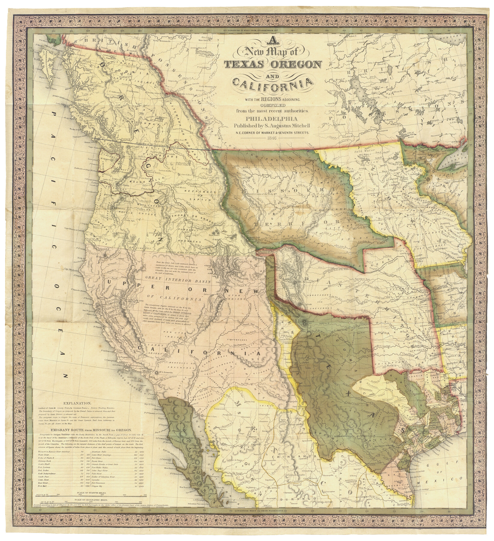
A New Map of Texas, Oregon and California with the regions adjoining, compiled from the most recent authorities
-
Map/Doc
93872
-
Collection
Holcomb Map Collection
-
Object Dates
1846 (Creation Date)
-
People and Organizations
S. Augustus Mitchell (Publisher)
-
Subjects
New Southwest Republic of Texas
-
Height x Width
23.2 x 21.2 inches
58.9 x 53.8 cm
-
Comments
See 93873 for cover and booklet that accompanied this map. Courtesy of Frank and Carol Holcomb.
Part of: Holcomb Map Collection
Map of Asia designed to accompany Smith's Geography for Schools

Print $20.00
- Digital $50.00
Map of Asia designed to accompany Smith's Geography for Schools
1850
Size 9.6 x 12.0 inches
Map/Doc 93896
A.R. Roessler's Latest Map of the State of Texas Exhibiting Mineral and Agricultural Districts, Post Offices & Mailroutes, Railroads projected and finished, Timber, Prairie, Swamp Lands, etc. etc. etc.

Print $20.00
- Digital $50.00
A.R. Roessler's Latest Map of the State of Texas Exhibiting Mineral and Agricultural Districts, Post Offices & Mailroutes, Railroads projected and finished, Timber, Prairie, Swamp Lands, etc. etc. etc.
1874
Size 39.9 x 44.6 inches
Map/Doc 95369

America with those known parts in that unknowne worlde both people and manner of buildings

Print $20.00
- Digital $50.00
America with those known parts in that unknowne worlde both people and manner of buildings
1626
Size 17.2 x 22.3 inches
Map/Doc 93830
A New Map of Texas with the Contiguous American & Mexican States

Print $20.00
- Digital $50.00
A New Map of Texas with the Contiguous American & Mexican States
1835
Size 12.9 x 15.8 inches
Map/Doc 93853
North America

Print $20.00
- Digital $50.00
North America
1823
Size 21.9 x 25.6 inches
Map/Doc 93842
Map of Texas containing the latest Grants and Discoveries

Print $20.00
- Digital $50.00
Map of Texas containing the latest Grants and Discoveries
1836
Size 12.7 x 9.1 inches
Map/Doc 93855
Il Disegno del discoperto della nova Franza, il quale se havuto ultimamente dalla novissima navigatione dè Francesi in quel luogo

Print $20.00
- Digital $50.00
Il Disegno del discoperto della nova Franza, il quale se havuto ultimamente dalla novissima navigatione dè Francesi in quel luogo
1566
Size 12.6 x 18.6 inches
Map/Doc 93804
Nova et Acurata Totius Americae Tabula

Print $40.00
Nova et Acurata Totius Americae Tabula
1608
Size 40.8 x 56.5 inches
Map/Doc 97019
Pressler's Map of Texas

Print $2.00
- Digital $50.00
Pressler's Map of Texas
1867
Size 9.0 x 6.0 inches
Map/Doc 93920
Tabula Terre Nove

Print $20.00
- Digital $50.00
Tabula Terre Nove
1513
Size 18.7 x 24.6 inches
Map/Doc 93800
Central Europe designed to accompany Smith's Geography for Schools

Print $20.00
- Digital $50.00
Central Europe designed to accompany Smith's Geography for Schools
1850
Size 12.1 x 9.8 inches
Map/Doc 93895
You may also like

Galveston County NRC Article 33.136 Sketch 26

Print $45.00
- Digital $50.00
Galveston County NRC Article 33.136 Sketch 26
2003
Size 32.6 x 24.3 inches
Map/Doc 81943
Tom Green County Sketch File 31

Print $40.00
- Digital $50.00
Tom Green County Sketch File 31
Size 14.2 x 13.4 inches
Map/Doc 38190
Flight Mission No. CUG-2P, Frame 23, Kleberg County

Print $20.00
- Digital $50.00
Flight Mission No. CUG-2P, Frame 23, Kleberg County
1956
Size 18.6 x 22.3 inches
Map/Doc 86187
Jefferson County Working Sketch 12

Print $20.00
- Digital $50.00
Jefferson County Working Sketch 12
1947
Size 29.9 x 39.4 inches
Map/Doc 66555
Stonewall County Sketch File 28

Print $14.00
- Digital $50.00
Stonewall County Sketch File 28
1970
Size 14.3 x 8.9 inches
Map/Doc 37300
Houston, Texas (Looking South)

Print $20.00
Houston, Texas (Looking South)
1891
Size 41.1 x 25.3 inches
Map/Doc 93465
[H. & T. C. 46, Sections 79- 84]
![91262, [H. & T. C. 46, Sections 79- 84], Twichell Survey Records](https://historictexasmaps.com/wmedia_w700/maps/91262-1.tif.jpg)
Print $20.00
- Digital $50.00
[H. & T. C. 46, Sections 79- 84]
Size 27.3 x 32.6 inches
Map/Doc 91262
Map of Texas with population and location of principal towns and cities, according to latest reliable statistics

Print $20.00
- Digital $50.00
Map of Texas with population and location of principal towns and cities, according to latest reliable statistics
1906
Size 19.0 x 20.7 inches
Map/Doc 95867
Bexar County State Real Property Sketch 6

Print $20.00
Bexar County State Real Property Sketch 6
2006
Size 22.2 x 33.1 inches
Map/Doc 96980
Fort Bend County Working Sketch 5

Print $20.00
- Digital $50.00
Fort Bend County Working Sketch 5
1915
Size 14.5 x 20.9 inches
Map/Doc 69211
Bell County Sketch File 14

Print $4.00
- Digital $50.00
Bell County Sketch File 14
Size 12.7 x 8.3 inches
Map/Doc 14392