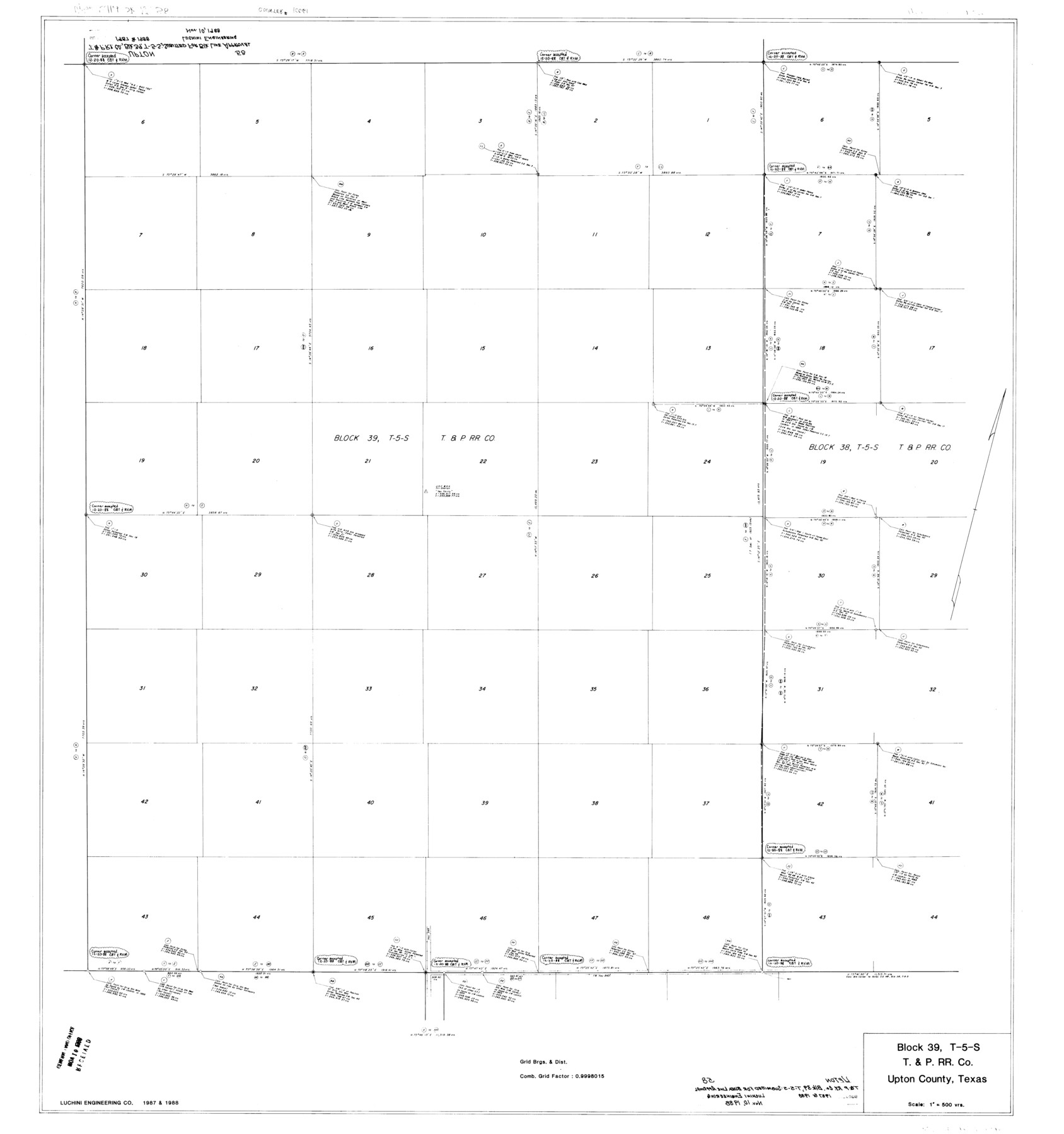
Upton County Rolled Sketch 58
Block 39, T-5-S, T. & P. R.R. Co., Upton County, Texas
-
Map/Doc
10061
-
Collection
General Map Collection
-
Object Dates
1988 (Creation Date)
1988/11/10 (File Date)
-
Counties
Upton
-
Subjects
Surveying Rolled Sketch
-
Height x Width
38.6 x 36.2 inches
98.0 x 92.0 cm
-
Medium
mylar, print
-
Scale
1" = 500 varas
-
Comments
See 46125 for another sheet.
Related maps
Upton County Rolled Sketch 58

Print $20.00
- Digital $50.00
Upton County Rolled Sketch 58
Size 39.0 x 35.0 inches
Map/Doc 46125
Part of: General Map Collection
Red River County Sketch File 10

Print $15.00
- Digital $50.00
Red River County Sketch File 10
1863
Size 9.1 x 7.4 inches
Map/Doc 35121
Rusk County Sketch File 19

Print $4.00
Rusk County Sketch File 19
Size 13.0 x 8.2 inches
Map/Doc 35526
Lavaca County Rolled Sketch 8

Print $40.00
- Digital $50.00
Lavaca County Rolled Sketch 8
1982
Size 36.5 x 65.6 inches
Map/Doc 10289
[Missouri, Kansas & Texas Line Map through Bastrop County]
![64028, [Missouri, Kansas & Texas Line Map through Bastrop County], General Map Collection](https://historictexasmaps.com/wmedia_w700/maps/64028.tif.jpg)
Print $40.00
- Digital $50.00
[Missouri, Kansas & Texas Line Map through Bastrop County]
1916
Size 26.2 x 121.8 inches
Map/Doc 64028
Jack County Sketch File 3

Print $6.00
- Digital $50.00
Jack County Sketch File 3
1857
Size 10.6 x 16.5 inches
Map/Doc 27504
Jasper County Working Sketch 28

Print $20.00
- Digital $50.00
Jasper County Working Sketch 28
1955
Size 22.6 x 15.6 inches
Map/Doc 66490
Mason County Boundary File 3a

Print $12.00
- Digital $50.00
Mason County Boundary File 3a
Size 8.9 x 8.2 inches
Map/Doc 56846
Parker County Boundary File 68

Print $12.00
- Digital $50.00
Parker County Boundary File 68
Size 8.1 x 3.6 inches
Map/Doc 57848
Culberson County Rolled Sketch 19A
Print $20.00
- Digital $50.00
Culberson County Rolled Sketch 19A
Size 23.2 x 28.6 inches
Map/Doc 5652
Castro County Sketch File 5a

Print $8.00
- Digital $50.00
Castro County Sketch File 5a
1904
Size 11.2 x 8.7 inches
Map/Doc 17491
Galveston County NRC Article 33.136 Sketch 62

Print $28.00
- Digital $50.00
Galveston County NRC Article 33.136 Sketch 62
2009
Size 24.0 x 36.0 inches
Map/Doc 94596
Gray County Working Sketch 3

Print $20.00
- Digital $50.00
Gray County Working Sketch 3
1958
Size 36.4 x 31.8 inches
Map/Doc 63234
You may also like
Liberty County Working Sketch 43

Print $20.00
- Digital $50.00
Liberty County Working Sketch 43
1953
Size 30.6 x 43.7 inches
Map/Doc 70502
Hunt County Boundary File 6

Print $6.00
- Digital $50.00
Hunt County Boundary File 6
Size 14.3 x 8.6 inches
Map/Doc 55225
Map of the Globe showing its continents, islands, mountain ranges, table lands, plains and slopes

Print $20.00
- Digital $50.00
Map of the Globe showing its continents, islands, mountain ranges, table lands, plains and slopes
1885
Size 12.2 x 18.5 inches
Map/Doc 93532
Tom Green County Rolled Sketch 21

Print $20.00
- Digital $50.00
Tom Green County Rolled Sketch 21
Size 20.2 x 12.9 inches
Map/Doc 8004
Flight Mission No. CRC-6R, Frame 38, Chambers County

Print $20.00
- Digital $50.00
Flight Mission No. CRC-6R, Frame 38, Chambers County
1956
Size 18.7 x 22.4 inches
Map/Doc 84971

Briscoe County Working Sketch 3

Print $20.00
- Digital $50.00
Briscoe County Working Sketch 3
1916
Size 28.1 x 22.0 inches
Map/Doc 67806
Refugio County Sketch File 20

Print $8.00
- Digital $50.00
Refugio County Sketch File 20
Size 14.4 x 8.8 inches
Map/Doc 35276
Map of Rains County

Print $20.00
- Digital $50.00
Map of Rains County
1873
Size 11.9 x 11.2 inches
Map/Doc 3973
Leon County Rolled Sketch 18

Print $20.00
- Digital $50.00
Leon County Rolled Sketch 18
1982
Size 33.1 x 34.8 inches
Map/Doc 6604
Morris County Rolled Sketch 2A

Print $20.00
- Digital $50.00
Morris County Rolled Sketch 2A
Size 22.7 x 17.7 inches
Map/Doc 10227
