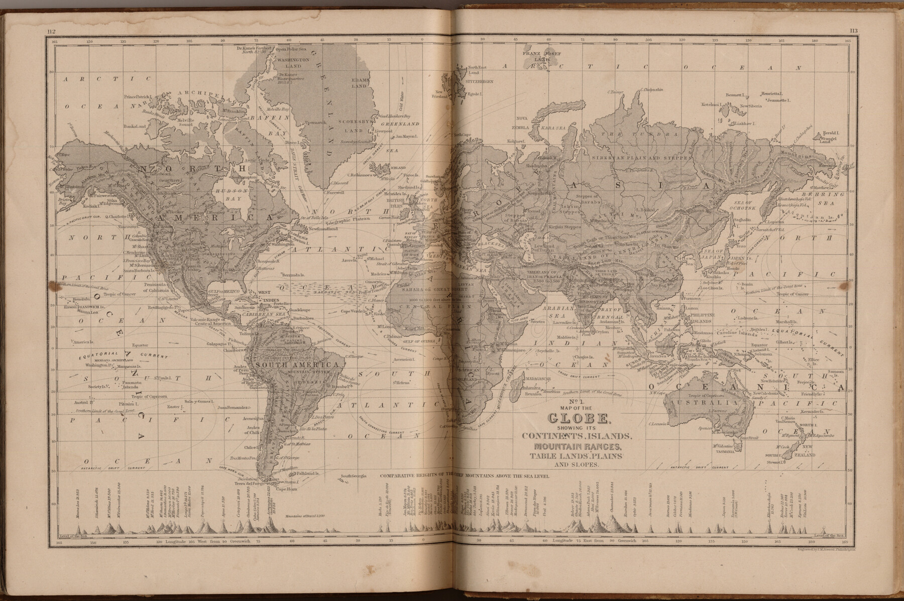
Map of the Globe showing its continents, islands, mountain ranges, table lands, plains and slopes
Mitchell's New Intermediate Geography Map No. 1
-
Map/Doc
93532
-
Collection
General Map Collection
-
Object Dates
1885 (Creation Date)
2013/7/12 (File Date)
-
People and Organizations
E. H. Butler and Co. (Publisher)
J. M. Atwood (Printer)
Galen Greaser (Donor)
S. Augustus Mitchell (Author)
-
Subjects
Atlas World
-
Height x Width
12.2 x 18.5 inches
31.0 x 47.0 cm
-
Comments
Donated by Galen Greaser in 2009. Map is part of volume: "Mitchell's New Intermediate Geography (Louisiana Edition)". See 93509 for complete atlas.
Related maps
Mitchell's New Intermediate Geography (Louisiana Edition)

Print $819.00
- Digital $50.00
Mitchell's New Intermediate Geography (Louisiana Edition)
1885
Size 12.5 x 10.0 inches
Map/Doc 93509
Part of: General Map Collection
Lubbock County Boundary File 3

Print $2.00
- Digital $50.00
Lubbock County Boundary File 3
Size 11.3 x 8.8 inches
Map/Doc 56490
Nueces County Rolled Sketch 127

Print $20.00
- Digital $50.00
Nueces County Rolled Sketch 127
1998
Size 24.1 x 36.4 inches
Map/Doc 7162
Motley County Sketch File C (N)

Print $48.00
- Digital $50.00
Motley County Sketch File C (N)
Size 7.7 x 18.4 inches
Map/Doc 31978
Houston Ship Channel, Atkinson Island to Alexander Island

Print $20.00
- Digital $50.00
Houston Ship Channel, Atkinson Island to Alexander Island
1960
Size 33.2 x 44.0 inches
Map/Doc 69900
Right of Way and Track Map San Antonio and Aransas Pass Railway Co.

Print $4.00
- Digital $50.00
Right of Way and Track Map San Antonio and Aransas Pass Railway Co.
1919
Size 11.9 x 18.5 inches
Map/Doc 62562
Maverick County Rolled Sketch 20

Print $20.00
- Digital $50.00
Maverick County Rolled Sketch 20
Size 24.5 x 38.7 inches
Map/Doc 6712
Kleberg County

Print $20.00
- Digital $50.00
Kleberg County
1913
Size 27.2 x 34.4 inches
Map/Doc 5006
Hardeman County Rolled Sketch 17

Print $40.00
- Digital $50.00
Hardeman County Rolled Sketch 17
1888
Size 57.9 x 31.1 inches
Map/Doc 9100
Upton County Working Sketch 5

Print $20.00
- Digital $50.00
Upton County Working Sketch 5
1909
Size 15.9 x 27.1 inches
Map/Doc 69501
Baylor County

Print $20.00
- Digital $50.00
Baylor County
1917
Size 47.3 x 40.7 inches
Map/Doc 66712
Webb County Sketch File 11

Print $18.00
- Digital $50.00
Webb County Sketch File 11
1883
Size 8.7 x 7.6 inches
Map/Doc 39770
[Kansas City, Mexico & Orient] Plat Showing Sections 10 & 17, Block 351, GC & SF Ry. Survey, Presidio County, Texas
![64270, [Kansas City, Mexico & Orient] Plat Showing Sections 10 & 17, Block 351, GC & SF Ry. Survey, Presidio County, Texas, General Map Collection](https://historictexasmaps.com/wmedia_w700/maps/64270-1.tif.jpg)
Print $20.00
- Digital $50.00
[Kansas City, Mexico & Orient] Plat Showing Sections 10 & 17, Block 351, GC & SF Ry. Survey, Presidio County, Texas
Size 17.6 x 16.0 inches
Map/Doc 64270
You may also like
Bandera County Working Sketch 36

Print $20.00
- Digital $50.00
Bandera County Working Sketch 36
1966
Size 22.5 x 29.5 inches
Map/Doc 67632
Flight Mission No. DQO-2K, Frame 91, Galveston County

Print $20.00
- Digital $50.00
Flight Mission No. DQO-2K, Frame 91, Galveston County
1952
Size 18.8 x 22.5 inches
Map/Doc 85018
[Capitol Leagues in Lamb County]
![91014, [Capitol Leagues in Lamb County], Twichell Survey Records](https://historictexasmaps.com/wmedia_w700/maps/91014-1.tif.jpg)
Print $2.00
- Digital $50.00
[Capitol Leagues in Lamb County]
1912
Size 12.7 x 8.8 inches
Map/Doc 91014
Sherman County Rolled Sketch 11

Print $20.00
- Digital $50.00
Sherman County Rolled Sketch 11
Size 34.0 x 35.0 inches
Map/Doc 9930
State Land for Sale on Mustang Island

Print $20.00
- Digital $50.00
State Land for Sale on Mustang Island
1910
Size 20.0 x 29.5 inches
Map/Doc 91493
[Public School Land Blocks]
![93151, [Public School Land Blocks], Twichell Survey Records](https://historictexasmaps.com/wmedia_w700/maps/93151-1.tif.jpg)
Print $40.00
- Digital $50.00
[Public School Land Blocks]
Size 45.0 x 114.7 inches
Map/Doc 93151
Bexar County Sketch File 31

Print $40.00
- Digital $50.00
Bexar County Sketch File 31
1867
Size 11.3 x 16.4 inches
Map/Doc 10920

Bowie County Working Sketch 10b

Print $20.00
- Digital $50.00
Bowie County Working Sketch 10b
1956
Size 31.1 x 37.6 inches
Map/Doc 67414
Culberson County Working Sketch 69

Print $40.00
- Digital $50.00
Culberson County Working Sketch 69
1975
Size 49.4 x 32.2 inches
Map/Doc 68523
Map of the Southwest Railway System

Print $20.00
- Digital $50.00
Map of the Southwest Railway System
1883
Size 16.0 x 28.8 inches
Map/Doc 93287
Anderson County Sketch File 24

Print $60.00
- Digital $50.00
Anderson County Sketch File 24
1942
Size 13.2 x 18.2 inches
Map/Doc 10803