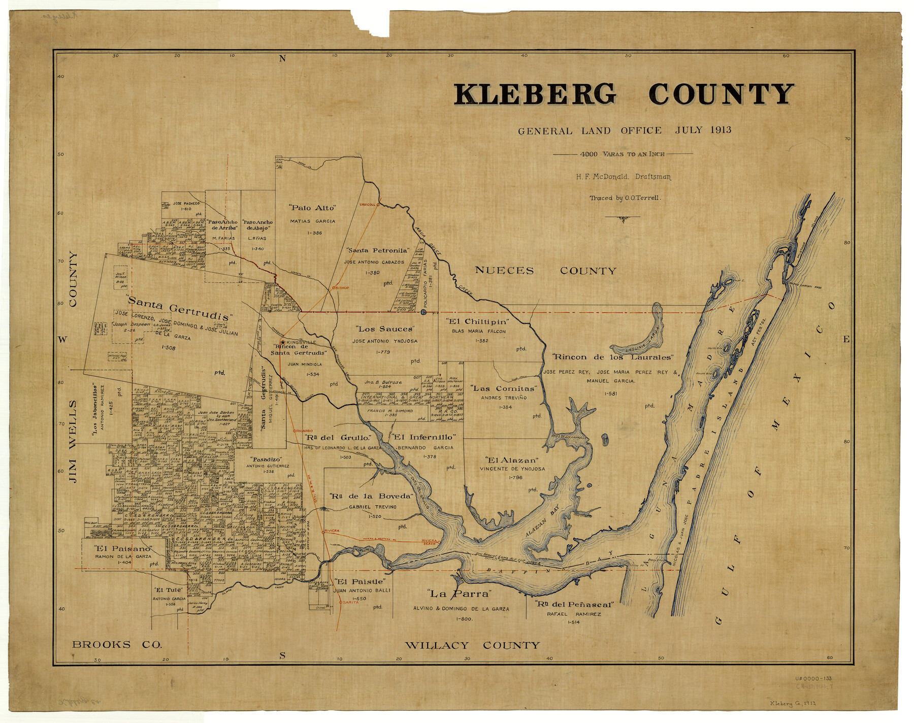
Kleberg County
-
Map/Doc
5006
-
Collection
General Map Collection
-
Object Dates
1913 (Creation Date)
-
People and Organizations
Texas General Land Office (Publisher)
H.F. McDonald (Compiler)
H.F. McDonald (Draftsman)
-
Counties
Kleberg
-
Subjects
County
-
Height x Width
27.2 x 34.4 inches
69.1 x 87.4 cm
-
Comments
Traced by O. O. Terrell.
Tracing of current county map counter number 1878.
Part of: General Map Collection

Gaines County Sketch File 20

Print $12.00
- Digital $50.00
Gaines County Sketch File 20
1906
Size 7.1 x 8.9 inches
Map/Doc 23335
Report of the Superintendent of the Coast Survey showing the progress of the survey during the year 1852

Report of the Superintendent of the Coast Survey showing the progress of the survey during the year 1852
1853
Map/Doc 81738
Maps of Gulf Intracoastal Waterway, Texas - Sabine River to the Rio Grande and connecting waterways including ship channels

Print $20.00
- Digital $50.00
Maps of Gulf Intracoastal Waterway, Texas - Sabine River to the Rio Grande and connecting waterways including ship channels
1966
Size 14.6 x 22.2 inches
Map/Doc 61970
Walker County Working Sketch 2

Print $20.00
- Digital $50.00
Walker County Working Sketch 2
1918
Size 16.7 x 14.5 inches
Map/Doc 72282
Terrell County Sketch File 9

Print $12.00
- Digital $50.00
Terrell County Sketch File 9
Size 9.8 x 8.5 inches
Map/Doc 37904
Freestone County Sketch File 19

Print $8.00
- Digital $50.00
Freestone County Sketch File 19
Size 12.4 x 8.1 inches
Map/Doc 23078
Kent County Sketch File 10

Print $42.00
- Digital $50.00
Kent County Sketch File 10
1924
Size 22.1 x 35.5 inches
Map/Doc 11914
Flight Mission No. DIX-3P, Frame 133, Aransas County

Print $20.00
- Digital $50.00
Flight Mission No. DIX-3P, Frame 133, Aransas County
1956
Size 17.8 x 21.1 inches
Map/Doc 83763
Flight Mission No. BQY-4M, Frame 121, Harris County

Print $20.00
- Digital $50.00
Flight Mission No. BQY-4M, Frame 121, Harris County
1953
Size 18.8 x 22.5 inches
Map/Doc 85289
Hemphill County Rolled Sketch 10

Print $20.00
- Digital $50.00
Hemphill County Rolled Sketch 10
Size 19.4 x 27.6 inches
Map/Doc 6192
Chambers County Sketch File 30

Print $4.00
- Digital $50.00
Chambers County Sketch File 30
1859
Size 11.0 x 8.6 inches
Map/Doc 17612
You may also like
Crockett County Working Sketch 57

Print $20.00
- Digital $50.00
Crockett County Working Sketch 57
1954
Size 35.9 x 38.8 inches
Map/Doc 68390

Brown County Rolled Sketch 1

Print $20.00
- Digital $50.00
Brown County Rolled Sketch 1
1969
Size 15.4 x 22.1 inches
Map/Doc 5348
Map of Harris County

Print $20.00
- Digital $50.00
Map of Harris County
1893
Size 29.7 x 33.8 inches
Map/Doc 3632
Haskell County Sketch File 22

Print $6.00
- Digital $50.00
Haskell County Sketch File 22
Size 14.3 x 8.8 inches
Map/Doc 26179
El Paso County Sketch File 20

Print $40.00
- Digital $50.00
El Paso County Sketch File 20
Size 31.4 x 49.4 inches
Map/Doc 10447
Hutchinson County Rolled Sketch 40

Print $20.00
- Digital $50.00
Hutchinson County Rolled Sketch 40
1981
Size 26.1 x 37.5 inches
Map/Doc 6298
Donley County Sketch File 11

Print $8.00
- Digital $50.00
Donley County Sketch File 11
1892
Size 14.6 x 8.3 inches
Map/Doc 21244
Houston & Great Northern R.R. from Troupe in Smith Co. the point of junction with International R.R. to Mineola in Wood Co. the point of junction with T. & P. R.R.

Print $22.00
- Digital $50.00
Houston & Great Northern R.R. from Troupe in Smith Co. the point of junction with International R.R. to Mineola in Wood Co. the point of junction with T. & P. R.R.
1873
Size 21.2 x 8.6 inches
Map/Doc 64301
Jack County Sketch File 7

Print $6.00
- Digital $50.00
Jack County Sketch File 7
1857
Size 6.7 x 12.4 inches
Map/Doc 27516
Nolan County, Texas

Print $20.00
- Digital $50.00
Nolan County, Texas
1870
Size 23.9 x 19.5 inches
Map/Doc 744
Current Miscellaneous File 112

Print $138.00
- Digital $50.00
Current Miscellaneous File 112
Size 11.3 x 8.7 inches
Map/Doc 74718