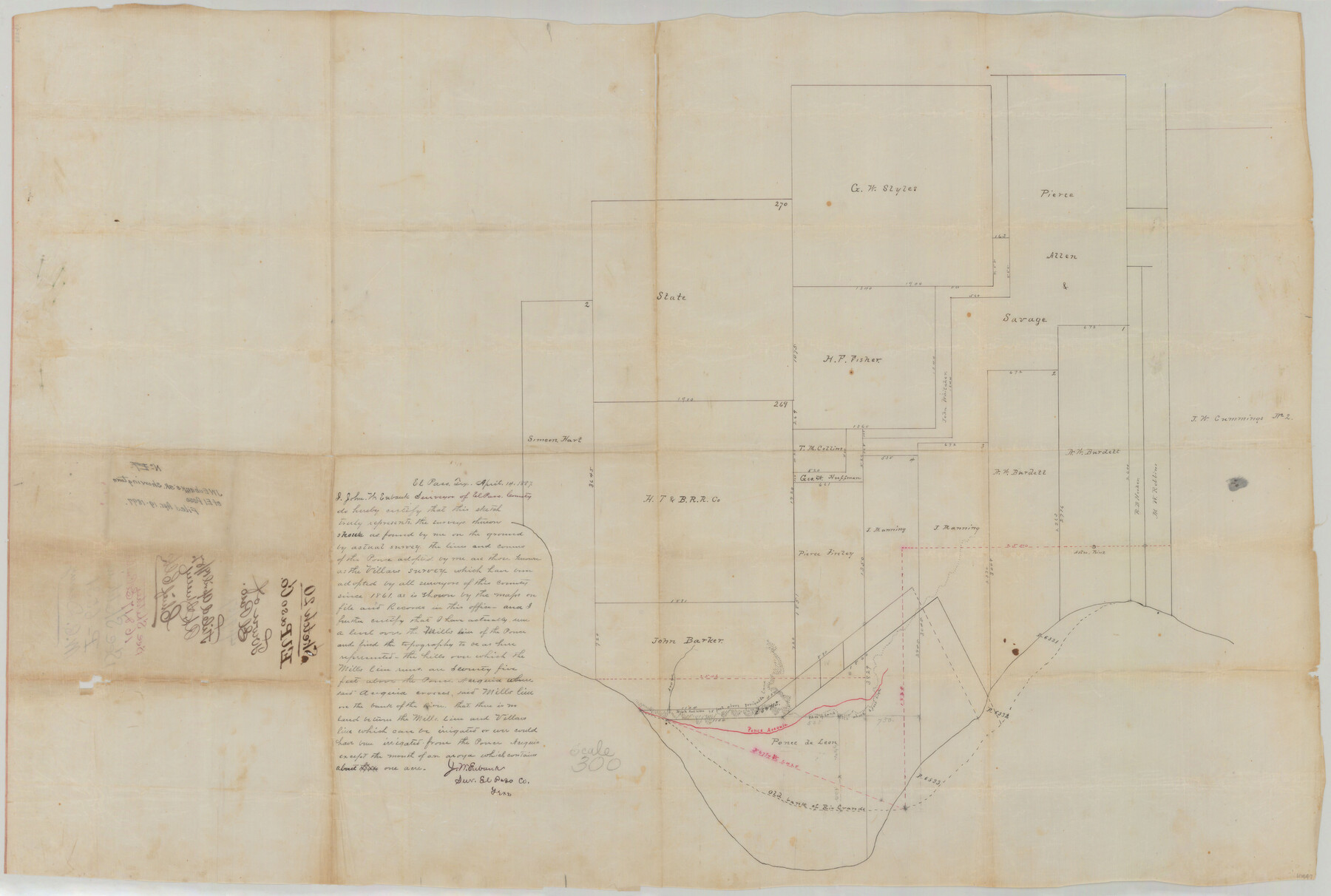
El Paso County Sketch File 20
[Pencil sketch and calculations relating to town plot of El Paso]
-
Map/Doc
10447
-
Collection
General Map Collection
-
Object Dates
1897/4/19 (File Date)
1861 (Survey Date)
-
People and Organizations
John W. Eubank (Surveyor/Engineer)
-
Counties
El Paso
-
Subjects
Surveying Sketch File
-
Height x Width
31.4 x 49.4 inches
79.8 x 125.5 cm
-
Medium
paper, manuscript
-
Scale
1:300
-
Features
Rio Grande
Ponce Acequia
Old bank of Rio Grande
Part of: General Map Collection
Pecos County Working Sketch 101

Print $20.00
- Digital $50.00
Pecos County Working Sketch 101
1970
Size 43.3 x 31.1 inches
Map/Doc 71574
Lavaca County Sketch File 21

Print $40.00
- Digital $50.00
Lavaca County Sketch File 21
1951
Size 60.6 x 39.1 inches
Map/Doc 10520
Kendall County Rolled Sketch 7

Print $20.00
- Digital $50.00
Kendall County Rolled Sketch 7
Size 29.0 x 27.3 inches
Map/Doc 6460
Flight Mission No. DQO-7K, Frame 76, Galveston County

Print $20.00
- Digital $50.00
Flight Mission No. DQO-7K, Frame 76, Galveston County
1952
Size 18.8 x 22.5 inches
Map/Doc 85103
Orange County - West one half of Sabine River showing leases 5 & 6 traced from U. S. C. & G. S. chart no. 533

Print $20.00
- Digital $50.00
Orange County - West one half of Sabine River showing leases 5 & 6 traced from U. S. C. & G. S. chart no. 533
1957
Size 30.6 x 35.4 inches
Map/Doc 2899
Menard County Rolled Sketch 12

Print $20.00
- Digital $50.00
Menard County Rolled Sketch 12
Size 14.4 x 21.7 inches
Map/Doc 6758
Flight Mission No. DCL-7C, Frame 113, Kenedy County

Print $20.00
- Digital $50.00
Flight Mission No. DCL-7C, Frame 113, Kenedy County
1943
Size 18.5 x 22.2 inches
Map/Doc 86078
Stephens County Working Sketch 29

Print $20.00
- Digital $50.00
Stephens County Working Sketch 29
1977
Size 31.0 x 27.7 inches
Map/Doc 63972
Hudspeth County Working Sketch 2

Print $20.00
- Digital $50.00
Hudspeth County Working Sketch 2
1912
Size 22.3 x 17.7 inches
Map/Doc 66283
Crockett County Working Sketch 94

Print $20.00
- Digital $50.00
Crockett County Working Sketch 94
1979
Size 43.1 x 28.7 inches
Map/Doc 68427
Flight Mission No. CRE-1R, Frame 192, Jackson County

Print $20.00
- Digital $50.00
Flight Mission No. CRE-1R, Frame 192, Jackson County
1956
Size 18.5 x 22.3 inches
Map/Doc 85346
Van Zandt County Sketch File 14

Print $4.00
- Digital $50.00
Van Zandt County Sketch File 14
1858
Size 7.9 x 8.1 inches
Map/Doc 39404
You may also like
Dimmit County Rolled Sketch 13

Print $20.00
- Digital $50.00
Dimmit County Rolled Sketch 13
1944
Size 17.7 x 26.7 inches
Map/Doc 5722
Galveston County Sketch File 35

Print $8.00
- Digital $50.00
Galveston County Sketch File 35
1934
Size 11.3 x 8.8 inches
Map/Doc 23419
Grayson County Boundary File 4a

Print $24.00
- Digital $50.00
Grayson County Boundary File 4a
Size 10.0 x 42.7 inches
Map/Doc 53956
Flight Mission No. DQO-1K, Frame 156, Galveston County

Print $20.00
- Digital $50.00
Flight Mission No. DQO-1K, Frame 156, Galveston County
1952
Size 18.8 x 22.4 inches
Map/Doc 85009
[Mrs. May Vinson Survey]
![91942, [Mrs. May Vinson Survey], Twichell Survey Records](https://historictexasmaps.com/wmedia_w700/maps/91942-1.tif.jpg)
Print $20.00
- Digital $50.00
[Mrs. May Vinson Survey]
Size 34.0 x 22.8 inches
Map/Doc 91942
Caldwell County Sketch File 4a

Print $8.00
- Digital $50.00
Caldwell County Sketch File 4a
1898
Size 11.2 x 8.8 inches
Map/Doc 35835
The Judicial District/County of Menard. December 7, 1841

Print $20.00
The Judicial District/County of Menard. December 7, 1841
2020
Size 22.4 x 21.7 inches
Map/Doc 96336
Map of Galveston, Turtle & East Bays & portions of the Gulf of Mexico in Chambers & Galveston Counties, Texas showing subdivision for mineral development

Print $40.00
- Digital $50.00
Map of Galveston, Turtle & East Bays & portions of the Gulf of Mexico in Chambers & Galveston Counties, Texas showing subdivision for mineral development
1949
Size 48.9 x 54.8 inches
Map/Doc 2977
Jackson County Sketch File 8

Print $20.00
- Digital $50.00
Jackson County Sketch File 8
Size 30.5 x 35.7 inches
Map/Doc 10503
La Salle County

Print $20.00
- Digital $50.00
La Salle County
1886
Size 25.4 x 21.3 inches
Map/Doc 3795
Presidio County Rolled Sketch 59

Print $20.00
- Digital $50.00
Presidio County Rolled Sketch 59
Size 27.6 x 18.2 inches
Map/Doc 7352
Orange County NRC Article 33.136 Sketch 1

Print $20.00
- Digital $50.00
Orange County NRC Article 33.136 Sketch 1
2004
Size 23.8 x 34.5 inches
Map/Doc 81979