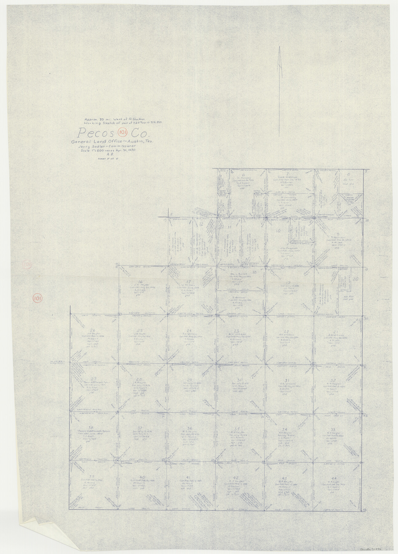
Pecos County Working Sketch 101
-
Map/Doc
71574
-
Collection
General Map Collection
-
Object Dates
4/30/1970 (Creation Date)
-
Counties
Pecos
-
Subjects
Surveying Working Sketch
-
Height x Width
43.3 x 31.1 inches
110.0 x 79.0 cm
-
Scale
1" = 500 varas
Part of: General Map Collection
Map of The Surveyed Part of Peters Colony Texas

Print $40.00
- Digital $50.00
Map of The Surveyed Part of Peters Colony Texas
1852
Size 54.0 x 28.8 inches
Map/Doc 3155
Pecos County Working Sketch 74

Print $40.00
- Digital $50.00
Pecos County Working Sketch 74
1957
Size 101.0 x 38.7 inches
Map/Doc 71546
Blanco County Working Sketch 12

Print $3.00
- Digital $50.00
Blanco County Working Sketch 12
1943
Size 11.9 x 10.9 inches
Map/Doc 67372
Limestone County Working Sketch 14

Print $20.00
- Digital $50.00
Limestone County Working Sketch 14
1922
Size 36.2 x 34.1 inches
Map/Doc 70564
Hays County Working Sketch 9

Print $40.00
- Digital $50.00
Hays County Working Sketch 9
1949
Size 22.8 x 50.5 inches
Map/Doc 66083
Flight Mission No. CRC-1R, Frame 153, Chambers County

Print $20.00
- Digital $50.00
Flight Mission No. CRC-1R, Frame 153, Chambers County
1956
Size 18.8 x 22.5 inches
Map/Doc 84715
[Sketch for Mineral Application 19560 - 19588 - San Bernard River]
![65660, [Sketch for Mineral Application 19560 - 19588 - San Bernard River], General Map Collection](https://historictexasmaps.com/wmedia_w700/maps/65660.tif.jpg)
Print $40.00
- Digital $50.00
[Sketch for Mineral Application 19560 - 19588 - San Bernard River]
Size 98.0 x 33.0 inches
Map/Doc 65660
Carte du Canada et de la Louisiane qui forment la Nouvelle France et des colonies angloises ou sont representez les pays contestez

Print $20.00
- Digital $50.00
Carte du Canada et de la Louisiane qui forment la Nouvelle France et des colonies angloises ou sont representez les pays contestez
1756
Size 21.5 x 29.6 inches
Map/Doc 97415

Wichita County Sketch File 36

Print $20.00
- Digital $50.00
Wichita County Sketch File 36
1894
Size 20.1 x 25.9 inches
Map/Doc 12689
Presidio County Sketch File 64a

Print $4.00
- Digital $50.00
Presidio County Sketch File 64a
1939
Size 11.3 x 8.8 inches
Map/Doc 34652
Jackson County Sketch File 22

Print $10.00
- Digital $50.00
Jackson County Sketch File 22
Size 11.2 x 8.7 inches
Map/Doc 27698
You may also like
[Sketch for Mineral Application 24072, San Jacinto River]
![65600, [Sketch for Mineral Application 24072, San Jacinto River], General Map Collection](https://historictexasmaps.com/wmedia_w700/maps/65600.tif.jpg)
Print $20.00
- Digital $50.00
[Sketch for Mineral Application 24072, San Jacinto River]
1929
Size 25.0 x 18.4 inches
Map/Doc 65600
Liberty County Working Sketch 55

Print $20.00
- Digital $50.00
Liberty County Working Sketch 55
1962
Size 30.4 x 31.4 inches
Map/Doc 70515
[Sketch Showing Exception Number 3 and Exception Number 4]
![91400, [Sketch Showing Exception Number 3 and Exception Number 4], Twichell Survey Records](https://historictexasmaps.com/wmedia_w700/maps/91400-1.tif.jpg)
Print $20.00
- Digital $50.00
[Sketch Showing Exception Number 3 and Exception Number 4]
Size 26.7 x 18.8 inches
Map/Doc 91400
Hardin County Rolled Sketch 6

Print $20.00
- Digital $50.00
Hardin County Rolled Sketch 6
1938
Size 29.7 x 22.7 inches
Map/Doc 6079
Llano County Sketch File 10

Print $10.00
- Digital $50.00
Llano County Sketch File 10
1886
Size 8.2 x 7.6 inches
Map/Doc 30370
Crane County Working Sketch 1

Print $20.00
- Digital $50.00
Crane County Working Sketch 1
1906
Size 30.5 x 27.0 inches
Map/Doc 68278
Flight Mission No. DQO-8K, Frame 90, Galveston County

Print $20.00
- Digital $50.00
Flight Mission No. DQO-8K, Frame 90, Galveston County
1952
Size 17.9 x 22.3 inches
Map/Doc 85192
Chambers County Sketch File 44

Print $36.00
- Digital $50.00
Chambers County Sketch File 44
Size 13.9 x 8.7 inches
Map/Doc 17735
Garza County Sketch File 19

Print $20.00
- Digital $50.00
Garza County Sketch File 19
1905
Size 21.8 x 23.0 inches
Map/Doc 11546
[Tie Line, Zavala County School Land to North Line of Block D11, East and South to Double Lakes Corner]
![91868, [Tie Line, Zavala County School Land to North Line of Block D11, East and South to Double Lakes Corner], Twichell Survey Records](https://historictexasmaps.com/wmedia_w700/maps/91868-1.tif.jpg)
Print $20.00
- Digital $50.00
[Tie Line, Zavala County School Land to North Line of Block D11, East and South to Double Lakes Corner]
1900
Size 18.5 x 12.6 inches
Map/Doc 91868
Smith County Rolled Sketch 6D1

Print $20.00
- Digital $50.00
Smith County Rolled Sketch 6D1
Size 24.7 x 24.7 inches
Map/Doc 10703
Fayette County

Print $40.00
- Digital $50.00
Fayette County
1978
Size 42.5 x 54.7 inches
Map/Doc 73146