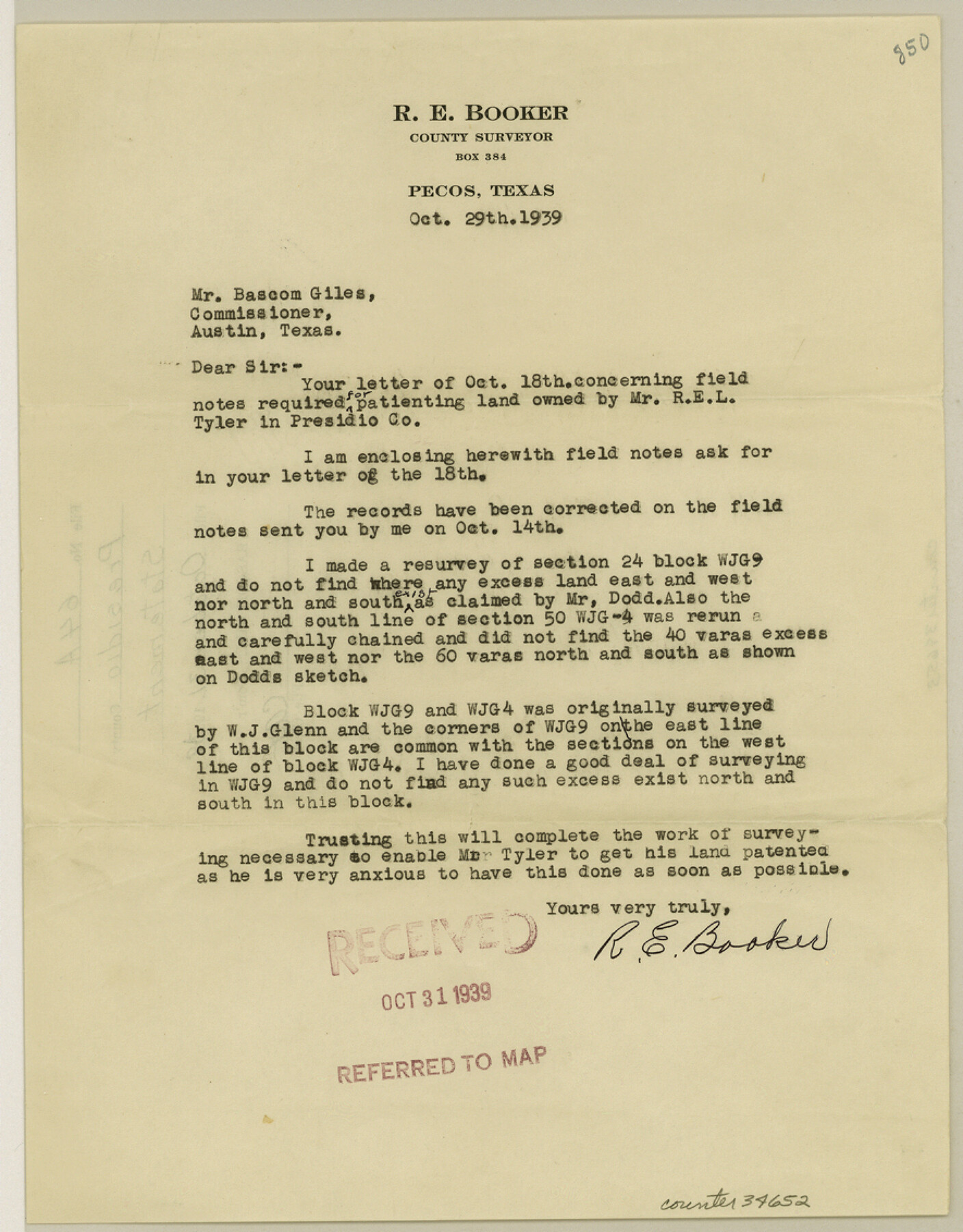
Presidio County Sketch File 64a
[Statement relative to Blocks WJG9 and WJG4]
-
Map/Doc
34652
-
Collection
General Map Collection
-
Object Dates
10/29/1939 (Creation Date)
10/31/1939 (File Date)
10/29/1939 (Correspondence Date)
-
People and Organizations
R.E. Booker (Surveyor/Engineer)
-
Counties
Presidio
-
Subjects
Surveying Sketch File
-
Height x Width
11.3 x 8.8 inches
28.7 x 22.4 cm
-
Medium
paper, print
Part of: General Map Collection
Flight Mission No. CGI-1N, Frame 178, Cameron County

Print $20.00
- Digital $50.00
Flight Mission No. CGI-1N, Frame 178, Cameron County
1955
Size 18.6 x 22.3 inches
Map/Doc 84513
Baylor County Rolled Sketch 9

Print $20.00
- Digital $50.00
Baylor County Rolled Sketch 9
1892
Size 18.2 x 26.1 inches
Map/Doc 5125
Hunt County Boundary File 9

Print $64.00
- Digital $50.00
Hunt County Boundary File 9
Size 8.9 x 8.9 inches
Map/Doc 55241
Maps & Lists Showing Prison Lands (Oil & Gas) Leased as of June 1955

Digital $50.00
Maps & Lists Showing Prison Lands (Oil & Gas) Leased as of June 1955
Size 11.1 x 8.8 inches
Map/Doc 62873
Orange County Sketch File 43

Print $4.00
- Digital $50.00
Orange County Sketch File 43
1873
Size 8.2 x 10.3 inches
Map/Doc 33385
Outer Continental Shelf Leasing Maps (Texas Offshore Operations)

Print $20.00
- Digital $50.00
Outer Continental Shelf Leasing Maps (Texas Offshore Operations)
1954
Size 11.6 x 12.3 inches
Map/Doc 75835
Galveston County NRC Article 33.136 Sketch 55A

Print $28.00
- Digital $50.00
Galveston County NRC Article 33.136 Sketch 55A
2009
Size 24.0 x 36.0 inches
Map/Doc 94616
Flight Mission No. DQO-1K, Frame 113, Galveston County

Print $20.00
- Digital $50.00
Flight Mission No. DQO-1K, Frame 113, Galveston County
1952
Size 18.9 x 22.7 inches
Map/Doc 84991
Tyler County Sketch File 6

Print $6.00
- Digital $50.00
Tyler County Sketch File 6
1848
Size 6.0 x 7.1 inches
Map/Doc 38630
Zapata County Rolled Sketch 12A

Print $40.00
- Digital $50.00
Zapata County Rolled Sketch 12A
1917
Size 54.0 x 40.0 inches
Map/Doc 10165

Mitchell County Sketch File 16a

Print $12.00
- Digital $50.00
Mitchell County Sketch File 16a
1933
Size 11.3 x 8.8 inches
Map/Doc 31703
You may also like
Lamar County Working Sketch 5

Print $20.00
- Digital $50.00
Lamar County Working Sketch 5
1962
Size 21.5 x 23.6 inches
Map/Doc 70266
Capitol Lands survey by J. T. Munson

Print $20.00
- Digital $50.00
Capitol Lands survey by J. T. Munson
Size 24.8 x 20.4 inches
Map/Doc 90585
Reagan County Working Sketch Graphic Index

Print $40.00
- Digital $50.00
Reagan County Working Sketch Graphic Index
1940
Size 48.3 x 36.7 inches
Map/Doc 76677
[Southeast Corner of Glasscock County]
![90786, [Southeast Corner of Glasscock County], Twichell Survey Records](https://historictexasmaps.com/wmedia_w700/maps/90786-1.tif.jpg)
Print $20.00
- Digital $50.00
[Southeast Corner of Glasscock County]
Size 19.2 x 22.5 inches
Map/Doc 90786
Hamilton County Working Sketch Graphic Index

Print $20.00
- Digital $50.00
Hamilton County Working Sketch Graphic Index
1972
Size 34.3 x 39.8 inches
Map/Doc 76564
Dimmit County Working Sketch 49

Print $40.00
- Digital $50.00
Dimmit County Working Sketch 49
1980
Size 78.8 x 44.7 inches
Map/Doc 68710
Pecos County Working Sketch 70

Print $20.00
- Digital $50.00
Pecos County Working Sketch 70
1957
Size 31.4 x 27.0 inches
Map/Doc 71542
![90260, [League 271], Twichell Survey Records](https://historictexasmaps.com/wmedia_w700/maps/90260-1.tif.jpg)
Pecos County Rolled Sketch 130

Print $20.00
- Digital $50.00
Pecos County Rolled Sketch 130
1950
Size 20.1 x 27.7 inches
Map/Doc 7268
Jefferson County Sketch File 21a

Print $44.00
- Digital $50.00
Jefferson County Sketch File 21a
Size 12.4 x 15.1 inches
Map/Doc 28175
Chambers County Sketch File 26

Print $20.00
- Digital $50.00
Chambers County Sketch File 26
1934
Size 19.6 x 24.6 inches
Map/Doc 11066
Rand, McNally & Co.'s Texas

Print $20.00
- Digital $50.00
Rand, McNally & Co.'s Texas
1887
Size 27.2 x 30.7 inches
Map/Doc 95884