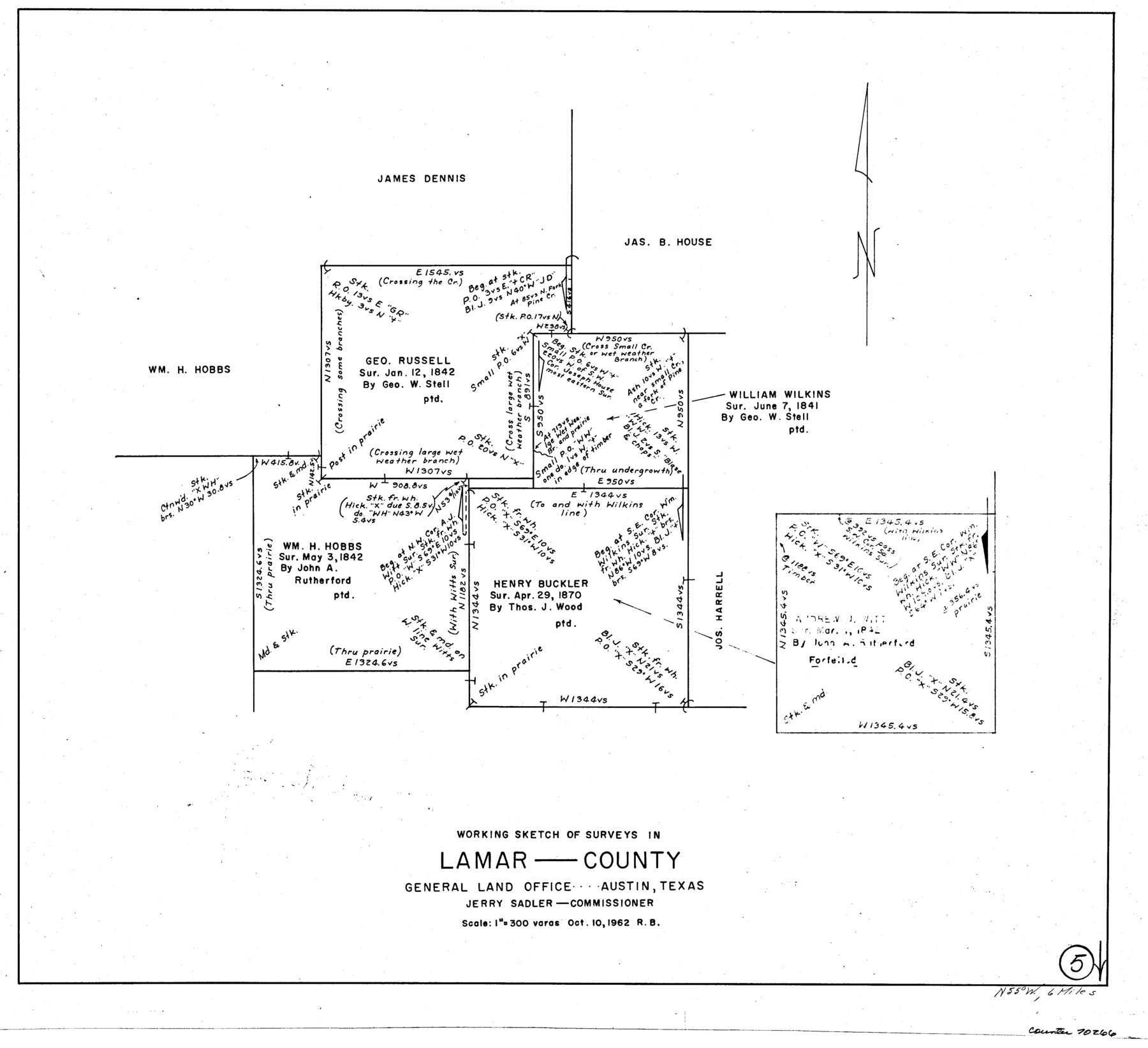
Lamar County Working Sketch 5
-
Map/Doc
70266
-
Collection
General Map Collection
-
Object Dates
10/10/1962 (Creation Date)
-
People and Organizations
Roy Buckholts (Draftsman)
-
Counties
Lamar
-
Subjects
Surveying Working Sketch
-
Height x Width
21.5 x 23.6 inches
54.6 x 59.9 cm
-
Scale
1" = 300 varas
Part of: General Map Collection
Hockley County Sketch File 11

Print $8.00
- Digital $50.00
Hockley County Sketch File 11
Size 14.3 x 9.0 inches
Map/Doc 26544
Irion County Working Sketch 3

Print $40.00
- Digital $50.00
Irion County Working Sketch 3
1921
Size 16.1 x 49.3 inches
Map/Doc 66412
Runnels County Rolled Sketch 32

Print $20.00
- Digital $50.00
Runnels County Rolled Sketch 32
Size 34.9 x 44.5 inches
Map/Doc 9868
Navigation Maps of Gulf Intracoastal Waterway, Port Arthur to Brownsville, Texas

Print $4.00
- Digital $50.00
Navigation Maps of Gulf Intracoastal Waterway, Port Arthur to Brownsville, Texas
1951
Size 16.7 x 21.6 inches
Map/Doc 65426
Flight Mission No. CLL-4N, Frame 31, Willacy County

Print $20.00
- Digital $50.00
Flight Mission No. CLL-4N, Frame 31, Willacy County
1954
Size 18.4 x 22.1 inches
Map/Doc 87104
Nouvelle Carte du Mexique du Texas et d'une partie des états limitrophes

Print $20.00
- Digital $50.00
Nouvelle Carte du Mexique du Texas et d'une partie des états limitrophes
1834
Size 39.9 x 27.4 inches
Map/Doc 94098
Leon County Working Sketch 52b

Print $20.00
- Digital $50.00
Leon County Working Sketch 52b
1982
Size 33.6 x 33.5 inches
Map/Doc 70452
Photostat of section of hydrographic surveys H-5399, H-4822, H-470

Print $20.00
- Digital $50.00
Photostat of section of hydrographic surveys H-5399, H-4822, H-470
1933
Size 25.9 x 18.3 inches
Map/Doc 61158
[Surveys in Robertson's Colony]
![78358, [Surveys in Robertson's Colony], General Map Collection](https://historictexasmaps.com/wmedia_w700/maps/78358.tif.jpg)
Print $20.00
- Digital $50.00
[Surveys in Robertson's Colony]
Size 18.6 x 26.5 inches
Map/Doc 78358
Rusk County Sketch File 20

Print $4.00
Rusk County Sketch File 20
1859
Size 10.2 x 8.1 inches
Map/Doc 35530
Walker County Working Sketch 12

Print $20.00
- Digital $50.00
Walker County Working Sketch 12
1943
Size 23.1 x 32.9 inches
Map/Doc 72292
El Paso County Rolled Sketch 52

Print $20.00
- Digital $50.00
El Paso County Rolled Sketch 52
1929
Size 19.1 x 24.3 inches
Map/Doc 5850
You may also like
Fayette County Working Sketch 10

Print $20.00
- Digital $50.00
Fayette County Working Sketch 10
1985
Size 27.1 x 38.5 inches
Map/Doc 69174
Andrews County Working Sketch 7

Print $20.00
- Digital $50.00
Andrews County Working Sketch 7
1954
Size 16.0 x 24.2 inches
Map/Doc 67053
Picturesque Glen Ridge, A Beautiful Suburb of Austin

Print $20.00
- Digital $50.00
Picturesque Glen Ridge, A Beautiful Suburb of Austin
1890
Size 28.9 x 40.9 inches
Map/Doc 584
Flight Mission No. CLL-1N, Frame 20, Willacy County

Print $20.00
- Digital $50.00
Flight Mission No. CLL-1N, Frame 20, Willacy County
1954
Size 18.4 x 22.1 inches
Map/Doc 87007
Flight Mission No. DCL-6C, Frame 133, Kenedy County

Print $20.00
- Digital $50.00
Flight Mission No. DCL-6C, Frame 133, Kenedy County
1943
Size 18.6 x 22.3 inches
Map/Doc 85963
[Sketch showing Block AX, North part of Block G, Block S and part of Block D]
![92018, [Sketch showing Block AX, North part of Block G, Block S and part of Block D], Twichell Survey Records](https://historictexasmaps.com/wmedia_w700/maps/92018-1.tif.jpg)
Print $20.00
- Digital $50.00
[Sketch showing Block AX, North part of Block G, Block S and part of Block D]
Size 33.2 x 44.1 inches
Map/Doc 92018
Presidio County Rolled Sketch S1

Print $20.00
- Digital $50.00
Presidio County Rolled Sketch S1
Size 13.3 x 18.8 inches
Map/Doc 7414
Polk County Sketch File 15

Print $8.00
- Digital $50.00
Polk County Sketch File 15
Size 12.7 x 8.4 inches
Map/Doc 34157
Encinal County

Print $20.00
- Digital $50.00
Encinal County
1895
Size 34.4 x 24.0 inches
Map/Doc 3516
[Sketch showing A. B. & M. Block 2]
![91701, [Sketch showing A. B. & M. Block 2], Twichell Survey Records](https://historictexasmaps.com/wmedia_w700/maps/91701-1.tif.jpg)
Print $2.00
- Digital $50.00
[Sketch showing A. B. & M. Block 2]
Size 7.5 x 5.8 inches
Map/Doc 91701
[Blocks S and H1]
![91436, [Blocks S and H1], Twichell Survey Records](https://historictexasmaps.com/wmedia_w700/maps/91436-1.tif.jpg)
Print $20.00
- Digital $50.00
[Blocks S and H1]
Size 23.0 x 10.2 inches
Map/Doc 91436
The Republic County of Colorado. Proposed, Late Fall 1837-January 1, 1838

Print $20.00
The Republic County of Colorado. Proposed, Late Fall 1837-January 1, 1838
2020
Size 18.4 x 21.7 inches
Map/Doc 96119