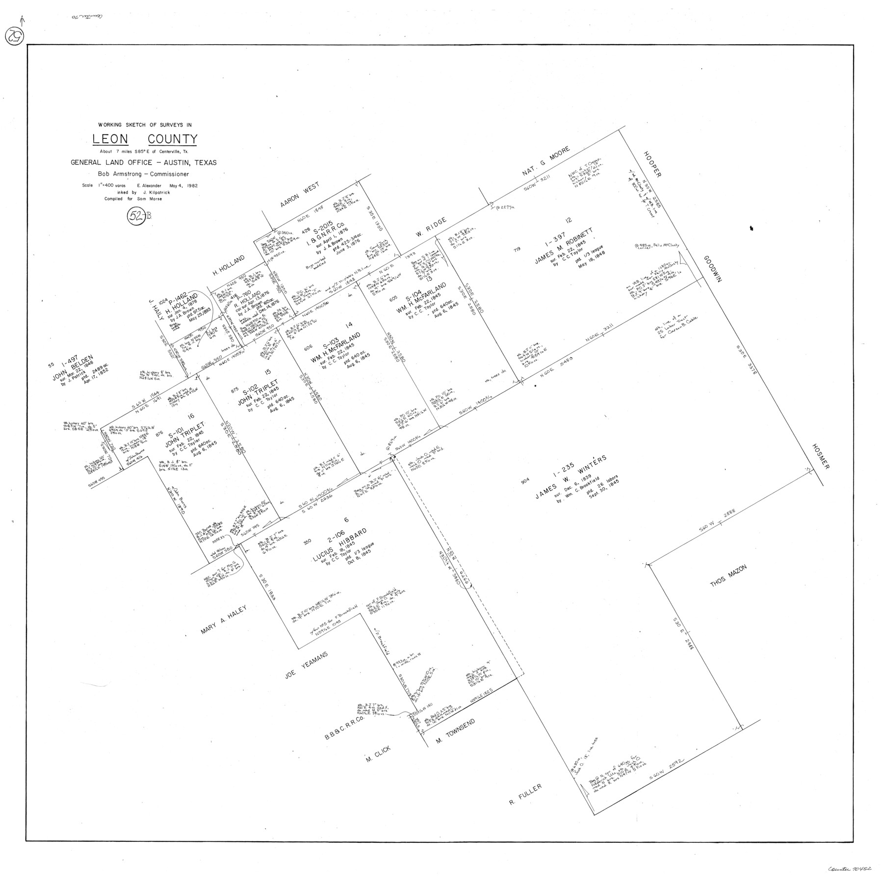
Leon County Working Sketch 52b
-
Map/Doc
70452
-
Collection
General Map Collection
-
Object Dates
5/4/1982 (Creation Date)
-
People and Organizations
Earl Alexander (Draftsman)
Joan Kilpatrick (Inker)
-
Counties
Leon
-
Subjects
Surveying Working Sketch
-
Height x Width
33.6 x 33.5 inches
85.3 x 85.1 cm
-
Scale
1" = 400 varas
Part of: General Map Collection
McMullen County Working Sketch 8

Print $20.00
- Digital $50.00
McMullen County Working Sketch 8
1936
Size 27.2 x 33.0 inches
Map/Doc 70709
Mason County Working Sketch 15

Print $40.00
- Digital $50.00
Mason County Working Sketch 15
1976
Size 61.9 x 45.4 inches
Map/Doc 70851
Randall County Rolled Sketch 9B

Print $20.00
- Digital $50.00
Randall County Rolled Sketch 9B
1985
Size 45.0 x 34.5 inches
Map/Doc 9810
Map of the reconnaissance in Texas by Lieuts Blake & Meade of the Corps of Topl. Engs.

Print $20.00
- Digital $50.00
Map of the reconnaissance in Texas by Lieuts Blake & Meade of the Corps of Topl. Engs.
1846
Size 27.1 x 22.5 inches
Map/Doc 2003
Andrews County Sketch File 10

Print $40.00
- Digital $50.00
Andrews County Sketch File 10
1950
Size 27.4 x 18.2 inches
Map/Doc 10810
Medina County Rolled Sketch 6

Print $40.00
- Digital $50.00
Medina County Rolled Sketch 6
1930
Size 51.1 x 45.2 inches
Map/Doc 9506
Denton County Sketch File 6

Print $4.00
- Digital $50.00
Denton County Sketch File 6
1855
Size 12.3 x 8.3 inches
Map/Doc 20696
Llano County Sketch File 7

Print $4.00
- Digital $50.00
Llano County Sketch File 7
Size 6.6 x 7.3 inches
Map/Doc 30362
[Sketch for Mineral Application 13440]
![65673, [Sketch for Mineral Application 13440], General Map Collection](https://historictexasmaps.com/wmedia_w700/maps/65673-1.tif.jpg)
Print $40.00
- Digital $50.00
[Sketch for Mineral Application 13440]
Size 42.4 x 66.0 inches
Map/Doc 65673
Shelby County Working Sketch 13

Print $40.00
- Digital $50.00
Shelby County Working Sketch 13
1946
Size 52.0 x 33.7 inches
Map/Doc 63866
Stephens County Boundary File 2

Print $34.00
- Digital $50.00
Stephens County Boundary File 2
Size 14.2 x 8.7 inches
Map/Doc 58866
Live Oak County Sketch File 25

Print $16.00
- Digital $50.00
Live Oak County Sketch File 25
1919
Size 9.0 x 8.5 inches
Map/Doc 30301
You may also like

Clay County Working Sketch 3

Print $20.00
- Digital $50.00
Clay County Working Sketch 3
1923
Size 19.7 x 9.3 inches
Map/Doc 68026
Guadalupe County Sketch File 25

Print $22.00
- Digital $50.00
Guadalupe County Sketch File 25
Size 12.7 x 15.7 inches
Map/Doc 24717
General Highway Map, Hardeman County, Texas

Print $20.00
General Highway Map, Hardeman County, Texas
1940
Size 25.0 x 18.3 inches
Map/Doc 79113
A Camera Journey through the Lower Valley of the Rio Grande - the Garden of Golden Grapefruit

A Camera Journey through the Lower Valley of the Rio Grande - the Garden of Golden Grapefruit
1929
Map/Doc 96744
General Highway Map, Bosque County, Texas

Print $20.00
General Highway Map, Bosque County, Texas
1961
Size 24.7 x 18.1 inches
Map/Doc 79378
[Block B9 and 3KA]
![90329, [Block B9 and 3KA], Twichell Survey Records](https://historictexasmaps.com/wmedia_w700/maps/90329-1.tif.jpg)
Print $20.00
- Digital $50.00
[Block B9 and 3KA]
Size 31.4 x 17.8 inches
Map/Doc 90329
The Republic County of Fayette. Created, December 14, 1837

Print $20.00
The Republic County of Fayette. Created, December 14, 1837
2020
Size 14.7 x 21.7 inches
Map/Doc 96131
Yates Pool, Pecos County, Texas

Print $3.00
- Digital $50.00
Yates Pool, Pecos County, Texas
1928
Size 11.5 x 10.3 inches
Map/Doc 91674
Harrison County Working Sketch 27

Print $20.00
- Digital $50.00
Harrison County Working Sketch 27
1988
Size 29.2 x 36.9 inches
Map/Doc 66047
Midland County Boundary File 4

Print $18.00
- Digital $50.00
Midland County Boundary File 4
Size 8.8 x 8.0 inches
Map/Doc 57176
Archer County Sketch File 8a

Print $8.00
- Digital $50.00
Archer County Sketch File 8a
Size 8.8 x 7.1 inches
Map/Doc 13639