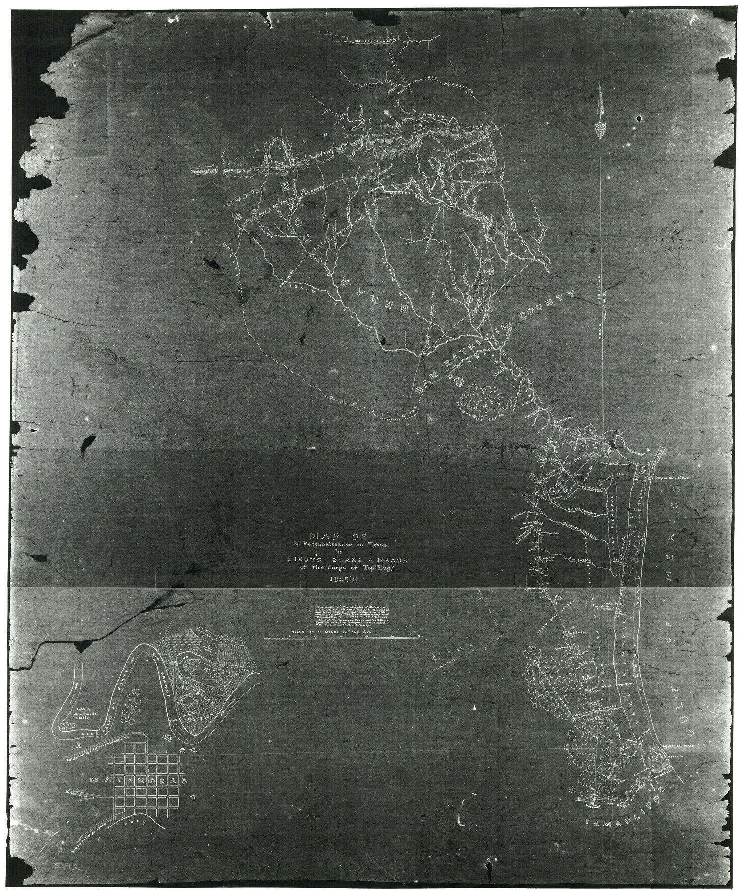
Map of the reconnaissance in Texas by Lieuts Blake & Meade of the Corps of Topl. Engs.
K-7-81
-
Map/Doc
2003
-
Collection
General Map Collection
-
Object Dates
1846 (Creation Date)
-
People and Organizations
Corps of Topographical Engineers (Author)
-
Subjects
Military
-
Height x Width
27.1 x 22.5 inches
68.8 x 57.2 cm
-
Medium
photograph, negative
-
Comments
Shows "Indian Wells" located on Padre Island and General Taylor's position across the Rio Grande from Matamoras.
Has many descriptions of the land. Copy from the National Archives, record group 77. -
Features
Rio San Fernando
Brushy Creek
San Antonio River
Rio Frio
Genl. Woll's Road to the Presidio de Rio Grande
San Miguel [River]
Medina River
Rio Cibolo
Rio Guadalupe
Rio Perdanales [sic]
Route of 2nd Dragoons
Rio Santa Gertrudis
San Patricio
Allasan Crossing
Baranca Blanca
La Parita Creek
Laha Creek
Chacanatilla Creek
San Christoval Creek
Cane Creek
Lipantitlan
Casa Blanca Creek
Dry Ravine
Bass Creek
Road to La Bahia
Brazos Santiago Pass
Boca Chica Bay
Route of the Army
Point Isabel
Laguna Madre
Padre Island
Salt Lake
Pinto Trail
Castroville
Upper Presidio Road
Chacon Creek
Corpus Christi Road
Rio Bobidos
Encinal
Route of Red Dragoons
Alamo
Corpus Christi Bay
Rio Aqua Dulce
Mustang Island
Laguna Penasca
Rio San Gertrudes [sic]
Corpus Christi Pass
Nueces Bay
Leona River
Pottaneo Creek
Saus Creek
Canon Crossing
San Geronimo Creek
Quihi Creek
Lucky Creek
Rio Perdinales [sic]
Bendina Creek
Francisco Perez Creek
Towaneany Creek
Rancheros Creek
Media Creek
Canon de Uvalde
Sabinal Creek
Canon de Sabinal
Gen. Woll's Road to the Creek Presidio de Rio Grande
Nueces River
Rio Grande
Rio Bravo
Rio Bravo del Norte or Rio Grande
[Road] to Rhinosa [sic] & Monterey [sic]
[Road] to Monterey [sic]
[Road] to mouth of River
Road to Gonzales
Puento Piedras Creek
Lepan Creek
Lucas Creek
Boraga Creek
Attascosa Creek
Lower Presidio Road
Salado Creek
Seco Creek
Calveras Creek
Chupedras Creek
Eagle Creek
Matamoras
Road to Seguin
Road to Seguin & Gonzales
Santa Clara Creek
Road to Nagodotenas
Road to Austin
Road to Austin & Nagodotenas
Saltones Creek
Pinte Trail
Violet Creek
Joshua's Creek
Part of: General Map Collection
Upshur County Sketch File 3a

Print $2.00
- Digital $50.00
Upshur County Sketch File 3a
Size 6.5 x 7.1 inches
Map/Doc 38736
Flight Mission No. DAG-21K, Frame 83, Matagorda County

Print $20.00
- Digital $50.00
Flight Mission No. DAG-21K, Frame 83, Matagorda County
1952
Size 18.7 x 22.4 inches
Map/Doc 86412

La Salle County Working Sketch 1

Print $20.00
- Digital $50.00
La Salle County Working Sketch 1
1929
Size 24.2 x 23.1 inches
Map/Doc 70302
Harris County Rolled Sketch 97

Print $20.00
- Digital $50.00
Harris County Rolled Sketch 97
Size 18.8 x 23.6 inches
Map/Doc 6135
Archer County Sketch File 7

Print $6.00
- Digital $50.00
Archer County Sketch File 7
Size 8.8 x 11.8 inches
Map/Doc 13636
Presidio County Working Sketch 37

Print $20.00
- Digital $50.00
Presidio County Working Sketch 37
1948
Size 26.9 x 43.3 inches
Map/Doc 71714
Flight Mission No. DQN-5K, Frame 74, Calhoun County

Print $20.00
- Digital $50.00
Flight Mission No. DQN-5K, Frame 74, Calhoun County
1953
Size 18.5 x 22.2 inches
Map/Doc 84407

Randall County Sketch File 5

Print $20.00
- Digital $50.00
Randall County Sketch File 5
1931
Size 23.9 x 41.7 inches
Map/Doc 10583
Map of Padre Island Showing Location of Zoning Districts

Print $20.00
- Digital $50.00
Map of Padre Island Showing Location of Zoning Districts
1971
Size 18.8 x 26.7 inches
Map/Doc 4809
Brazoria County Sketch File 14

Print $8.00
- Digital $50.00
Brazoria County Sketch File 14
1892
Size 13.9 x 8.7 inches
Map/Doc 14973
You may also like
San Patricio County Rolled Sketch 27B

Print $40.00
- Digital $50.00
San Patricio County Rolled Sketch 27B
Size 50.3 x 38.4 inches
Map/Doc 9892
[United States]
![97197, [United States], General Map Collection](https://historictexasmaps.com/wmedia_w700/maps/97197.tif.jpg)
Print $20.00
- Digital $50.00
[United States]
1848
Size 17.7 x 37.4 inches
Map/Doc 97197
Presidio County Sketch File 113

Print $6.00
- Digital $50.00
Presidio County Sketch File 113
Size 11.9 x 8.8 inches
Map/Doc 34829
Reagan County Working Sketch 14b

Print $20.00
- Digital $50.00
Reagan County Working Sketch 14b
Size 20.3 x 9.0 inches
Map/Doc 71855
Galveston County Sketch File 37

Print $30.00
- Digital $50.00
Galveston County Sketch File 37
1841
Size 14.3 x 8.8 inches
Map/Doc 23423
Eastland County Working Sketch 51

Print $20.00
- Digital $50.00
Eastland County Working Sketch 51
1982
Size 37.7 x 39.6 inches
Map/Doc 68832
Lampasas County Sketch File 14

Print $6.00
- Digital $50.00
Lampasas County Sketch File 14
Size 16.2 x 10.5 inches
Map/Doc 29426
[G. C. & S. F. Railroad Company, Block S]
![91330, [G. C. & S. F. Railroad Company, Block S], Twichell Survey Records](https://historictexasmaps.com/wmedia_w700/maps/91330-1.tif.jpg)
Print $2.00
- Digital $50.00
[G. C. & S. F. Railroad Company, Block S]
Size 8.6 x 6.0 inches
Map/Doc 91330
Right of Way and Track Map, Houston & Texas Central R.R. operated by the T. and N. O. R.R., Fort Worth Branch

Print $40.00
- Digital $50.00
Right of Way and Track Map, Houston & Texas Central R.R. operated by the T. and N. O. R.R., Fort Worth Branch
1918
Size 31.8 x 57.1 inches
Map/Doc 64781
Hockley County Rolled Sketch 3

Print $40.00
- Digital $50.00
Hockley County Rolled Sketch 3
Size 82.9 x 29.4 inches
Map/Doc 9173
[Elwood Ranch Field Notes]
![91090, [Elwood Ranch Field Notes], Twichell Survey Records](https://historictexasmaps.com/wmedia_w700/maps/91090-1.tif.jpg)
Print $20.00
- Digital $50.00
[Elwood Ranch Field Notes]
Size 12.4 x 16.4 inches
Map/Doc 91090
Runnels County Rolled Sketch 40

Print $20.00
- Digital $50.00
Runnels County Rolled Sketch 40
Size 33.5 x 40.9 inches
Map/Doc 7527