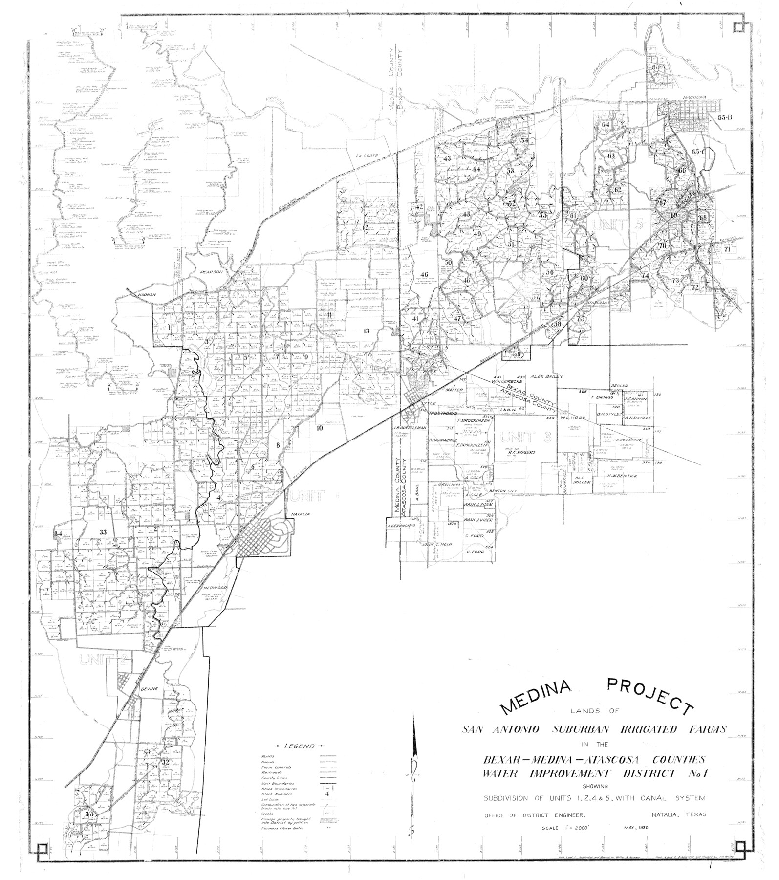
Medina County Rolled Sketch 6
Medina Project Lands of San Antonio Suburban Irrigated Farms in the Bexar-Medina-Atascosa Counties Water Improvement District No. 1 showing subdivision of units 1, 2, 4, & 5 with canal system
-
Map/Doc
9506
-
Collection
General Map Collection
-
Object Dates
1930 (Creation Date)
1956 (File Date)
-
Counties
Medina Bexar Atascosa
-
Subjects
Surveying Rolled Sketch
-
Height x Width
51.1 x 45.2 inches
129.8 x 114.8 cm
-
Scale
1" = 2000 feet
Part of: General Map Collection
Map of Tyler County

Print $20.00
- Digital $50.00
Map of Tyler County
1897
Size 42.2 x 39.2 inches
Map/Doc 63081
[Field book of Martin Duval, Wilbarger Co., H&TC RR Co. Blocks 13 & 14]
![61431, [Field book of Martin Duval, Wilbarger Co., H&TC RR Co. Blocks 13 & 14], General Map Collection](https://historictexasmaps.com/wmedia_w700/pdf_converted_jpg/qi_pdf_thumbnail_17161.jpg)
[Field book of Martin Duval, Wilbarger Co., H&TC RR Co. Blocks 13 & 14]
Size 6.7 x 8.2 inches
Map/Doc 61431
Sutton County Sketch File 62

Print $4.00
- Digital $50.00
Sutton County Sketch File 62
1959
Size 3.7 x 8.6 inches
Map/Doc 37564
Zavala County Working Sketch 1

Print $20.00
- Digital $50.00
Zavala County Working Sketch 1
Size 21.2 x 16.3 inches
Map/Doc 62076
Flight Mission No. BRE-1P, Frame 73, Nueces County

Print $20.00
- Digital $50.00
Flight Mission No. BRE-1P, Frame 73, Nueces County
1956
Size 18.5 x 22.4 inches
Map/Doc 86655
McLennan County Sketch File 23

Print $4.00
- Digital $50.00
McLennan County Sketch File 23
Size 5.6 x 3.2 inches
Map/Doc 31297
Flight Mission No. DCL-4C, Frame 5, Kenedy County

Print $20.00
- Digital $50.00
Flight Mission No. DCL-4C, Frame 5, Kenedy County
1943
Size 18.6 x 22.3 inches
Map/Doc 85806
Live Oak County Sketch File 16

Print $4.00
- Digital $50.00
Live Oak County Sketch File 16
Size 4.6 x 7.1 inches
Map/Doc 30282
Foard County Rolled Sketch 16

Print $40.00
- Digital $50.00
Foard County Rolled Sketch 16
1889
Size 36.9 x 72.8 inches
Map/Doc 8893
Flight Mission No. CUI-1H, Frame 167, Milam County

Print $20.00
- Digital $50.00
Flight Mission No. CUI-1H, Frame 167, Milam County
1951
Size 18.5 x 22.2 inches
Map/Doc 86609
Bailey County Sketch File 15

Print $18.00
- Digital $50.00
Bailey County Sketch File 15
1912
Size 8.7 x 11.2 inches
Map/Doc 13975
You may also like
Travis County Appraisal District Plat Map 2_3216

Print $20.00
- Digital $50.00
Travis County Appraisal District Plat Map 2_3216
Size 21.5 x 26.4 inches
Map/Doc 94223
Flight Mission No. CGI-1N, Frame 181, Cameron County

Print $20.00
- Digital $50.00
Flight Mission No. CGI-1N, Frame 181, Cameron County
1955
Size 18.7 x 22.2 inches
Map/Doc 84516
Aransas County Rolled Sketch 2

Print $40.00
- Digital $50.00
Aransas County Rolled Sketch 2
1950
Size 42.5 x 48.6 inches
Map/Doc 73611
Tarrant County Working Sketch 17

Print $20.00
- Digital $50.00
Tarrant County Working Sketch 17
1983
Size 24.6 x 20.7 inches
Map/Doc 62434
Map of Harris County

Print $20.00
- Digital $50.00
Map of Harris County
1893
Size 26.9 x 36.5 inches
Map/Doc 66855
Tom Green County Rolled Sketch 22

Print $20.00
- Digital $50.00
Tom Green County Rolled Sketch 22
1966
Size 38.0 x 43.6 inches
Map/Doc 10006
Burnet County Sketch File 25

Print $4.00
- Digital $50.00
Burnet County Sketch File 25
1873
Size 8.1 x 8.6 inches
Map/Doc 16725
Schleicher County Sketch File 23

Print $20.00
- Digital $50.00
Schleicher County Sketch File 23
Size 29.1 x 24.6 inches
Map/Doc 12302
La Salle County Sketch File 47

Print $8.00
- Digital $50.00
La Salle County Sketch File 47
1941
Size 14.2 x 8.9 inches
Map/Doc 29613
Jefferson County Rolled Sketch 51

Print $20.00
- Digital $50.00
Jefferson County Rolled Sketch 51
1965
Size 39.1 x 38.0 inches
Map/Doc 9307

Nueces County Rolled Sketch 76

Print $20.00
- Digital $50.00
Nueces County Rolled Sketch 76
1981
Size 18.3 x 23.6 inches
Map/Doc 6937