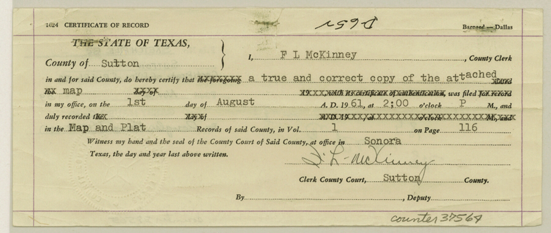
Sutton County Sketch File 62
[Certificate of filing of Rolled Sketch 58]
-
Map/Doc
37564
-
Collection
General Map Collection
-
Object Dates
9/12/1959 (Creation Date)
11/4/1959 (File Date)
9/12/1959 (Survey Date)
-
People and Organizations
William C. Wilson, Jr. (Surveyor/Engineer)
-
Counties
Sutton
-
Subjects
Surveying Sketch File
-
Height x Width
3.7 x 8.6 inches
9.4 x 21.8 cm
-
Medium
paper, print
Part of: General Map Collection
Travis County Rolled Sketch 39

Print $148.00
- Digital $50.00
Travis County Rolled Sketch 39
Size 6.7 x 9.9 inches
Map/Doc 49130
Brazoria County Working Sketch 4

Print $20.00
- Digital $50.00
Brazoria County Working Sketch 4
1920
Size 20.4 x 28.6 inches
Map/Doc 67489
Ochiltree County Boundary File 3

Print $10.00
- Digital $50.00
Ochiltree County Boundary File 3
Size 11.2 x 8.6 inches
Map/Doc 57677
[Map of Line Dividing Fannin and Nacogdoches Districts]
![3134, [Map of Line Dividing Fannin and Nacogdoches Districts], General Map Collection](https://historictexasmaps.com/wmedia_w700/maps/3134.tif.jpg)
Print $20.00
- Digital $50.00
[Map of Line Dividing Fannin and Nacogdoches Districts]
1850
Size 35.6 x 40.8 inches
Map/Doc 3134
Atascosa County Sketch File 9

Print $4.00
- Digital $50.00
Atascosa County Sketch File 9
1858
Size 8.1 x 12.6 inches
Map/Doc 13763
Flight Mission No. DIX-10P, Frame 62, Aransas County

Print $20.00
- Digital $50.00
Flight Mission No. DIX-10P, Frame 62, Aransas County
1956
Size 18.8 x 22.4 inches
Map/Doc 83923
Glasscock County Rolled Sketch 13

Print $20.00
- Digital $50.00
Glasscock County Rolled Sketch 13
Size 24.9 x 19.4 inches
Map/Doc 6019
Houston County Sketch File 3

Print $6.00
- Digital $50.00
Houston County Sketch File 3
Size 13.1 x 8.2 inches
Map/Doc 26748
Chambers County Sketch File 10b

Print $4.00
- Digital $50.00
Chambers County Sketch File 10b
1841
Size 9.6 x 8.2 inches
Map/Doc 17552
Flight Mission No. DCL-7C, Frame 147, Kenedy County

Print $20.00
- Digital $50.00
Flight Mission No. DCL-7C, Frame 147, Kenedy County
1943
Size 18.3 x 22.4 inches
Map/Doc 86104
Sketch of Surveys on Neches River

Print $2.00
- Digital $50.00
Sketch of Surveys on Neches River
1845
Size 5.7 x 5.9 inches
Map/Doc 182

You may also like
Sketch of Surveys on Caranchua and Tres Palacious Bayous, Jackson Co.

Print $2.00
- Digital $50.00
Sketch of Surveys on Caranchua and Tres Palacious Bayous, Jackson Co.
Size 7.9 x 7.8 inches
Map/Doc 69743
Roberts County

Print $20.00
- Digital $50.00
Roberts County
1889
Size 20.8 x 19.8 inches
Map/Doc 3993
Live Oak County Sketch File 18

Print $11.00
- Digital $50.00
Live Oak County Sketch File 18
1895
Size 10.5 x 17.0 inches
Map/Doc 30284
Edwards County Boundary File 2

Print $28.00
- Digital $50.00
Edwards County Boundary File 2
Size 11.2 x 8.6 inches
Map/Doc 52862
[Notes and map showing Public School Land Block K between Yoakum and Terry Counties]
![92011, [Notes and map showing Public School Land Block K between Yoakum and Terry Counties], Twichell Survey Records](https://historictexasmaps.com/wmedia_w700/maps/92011-1.tif.jpg)
Print $20.00
- Digital $50.00
[Notes and map showing Public School Land Block K between Yoakum and Terry Counties]
1902
Size 17.1 x 30.9 inches
Map/Doc 92011
Flight Mission No. DCL-5C, Frame 65, Kenedy County

Print $20.00
- Digital $50.00
Flight Mission No. DCL-5C, Frame 65, Kenedy County
1943
Size 17.9 x 22.4 inches
Map/Doc 85848
Map of McLennan County

Print $40.00
- Digital $50.00
Map of McLennan County
1896
Size 48.8 x 53.7 inches
Map/Doc 7952
Refugio County Working Sketch 14

Print $20.00
- Digital $50.00
Refugio County Working Sketch 14
1961
Size 25.7 x 21.7 inches
Map/Doc 63523
[Leagues 157-160]
![90298, [Leagues 157-160], Twichell Survey Records](https://historictexasmaps.com/wmedia_w700/maps/90298-1.tif.jpg)
Print $20.00
- Digital $50.00
[Leagues 157-160]
Size 8.2 x 22.6 inches
Map/Doc 90298
Pecos County Rolled Sketch 153

Print $20.00
- Digital $50.00
Pecos County Rolled Sketch 153
1960
Size 20.2 x 22.7 inches
Map/Doc 7282
Kleberg County Rolled Sketch 10-5

Print $20.00
- Digital $50.00
Kleberg County Rolled Sketch 10-5
1951
Size 37.6 x 35.6 inches
Map/Doc 9394
Fisher County Sketch File 12

Print $22.00
- Digital $50.00
Fisher County Sketch File 12
1893
Size 9.0 x 7.0 inches
Map/Doc 22577