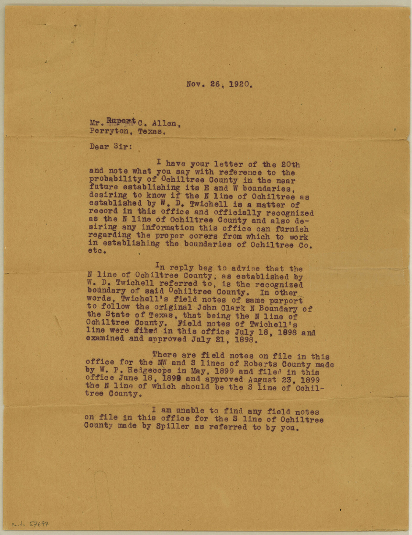
Ochiltree County Boundary File 3
[Letter regarding East and West Boundary lines of Ochiltree County]
-
Map/Doc
57677
-
Collection
General Map Collection
-
Counties
Ochiltree
-
Subjects
County Boundaries
-
Height x Width
11.2 x 8.6 inches
28.5 x 21.8 cm
Part of: General Map Collection
Hardin County Sketch File 50

Print $5.00
- Digital $50.00
Hardin County Sketch File 50
Size 13.5 x 9.2 inches
Map/Doc 25204
United States - Gulf Coast - From Latitude 26° 33' to the Rio Grande Texas

Print $20.00
- Digital $50.00
United States - Gulf Coast - From Latitude 26° 33' to the Rio Grande Texas
1913
Size 28.0 x 18.2 inches
Map/Doc 72833
Flight Mission No. CUG-1P, Frame 167, Kleberg County

Print $20.00
- Digital $50.00
Flight Mission No. CUG-1P, Frame 167, Kleberg County
1956
Size 18.7 x 22.4 inches
Map/Doc 86174
Surveys made on La Parita, March 1847

Print $2.00
- Digital $50.00
Surveys made on La Parita, March 1847
1847
Size 10.1 x 7.5 inches
Map/Doc 222
Map of the County of Nueces and portions of adjoining counties showing the locality, dates and claimants of the several grants made by the government of Spain and Mexico

Print $20.00
- Digital $50.00
Map of the County of Nueces and portions of adjoining counties showing the locality, dates and claimants of the several grants made by the government of Spain and Mexico
1859
Size 37.3 x 39.0 inches
Map/Doc 4677
Erath County Rolled Sketch 4

Print $20.00
- Digital $50.00
Erath County Rolled Sketch 4
Size 29.1 x 40.9 inches
Map/Doc 5866
Hemphill County Rolled Sketch 15A

Print $20.00
- Digital $50.00
Hemphill County Rolled Sketch 15A
1961
Size 26.6 x 17.3 inches
Map/Doc 6195
Map of Jack County

Print $20.00
- Digital $50.00
Map of Jack County
1895
Size 47.6 x 38.0 inches
Map/Doc 4988
Calhoun County Rolled Sketch 10

Print $20.00
- Digital $50.00
Calhoun County Rolled Sketch 10
Size 32.9 x 29.2 inches
Map/Doc 5366
[Corpus Christi Bay, Padre Island, Mustang Island, Laguna de la Madre, King and Kenedy's Pasture]
![73046, [Corpus Christi Bay, Padre Island, Mustang Island, Laguna de la Madre, King and Kenedy's Pasture], General Map Collection](https://historictexasmaps.com/wmedia_w700/maps/73046.tif.jpg)
Print $20.00
- Digital $50.00
[Corpus Christi Bay, Padre Island, Mustang Island, Laguna de la Madre, King and Kenedy's Pasture]
Size 26.4 x 18.2 inches
Map/Doc 73046
San Saba County Sketch File 18

Print $12.00
- Digital $50.00
San Saba County Sketch File 18
1919
Size 11.4 x 8.8 inches
Map/Doc 36460
Flight Mission No. CRC-3R, Frame 50, Chambers County

Print $20.00
- Digital $50.00
Flight Mission No. CRC-3R, Frame 50, Chambers County
1956
Size 18.7 x 22.3 inches
Map/Doc 84823
You may also like
Potter County Boundary File 3b

Print $12.00
- Digital $50.00
Potter County Boundary File 3b
Size 9.8 x 6.4 inches
Map/Doc 57979
Tarrant County Sketch File 30

Print $4.00
- Digital $50.00
Tarrant County Sketch File 30
1882
Size 8.9 x 5.9 inches
Map/Doc 37749
Hardeman County Working Sketch 14

Print $20.00
- Digital $50.00
Hardeman County Working Sketch 14
Size 30.8 x 42.2 inches
Map/Doc 63395
Rusk County Working Sketch 25

Print $20.00
- Digital $50.00
Rusk County Working Sketch 25
1941
Size 39.8 x 25.1 inches
Map/Doc 63661
Coleman County Sketch File 47

Print $12.00
- Digital $50.00
Coleman County Sketch File 47
1897
Size 14.1 x 8.6 inches
Map/Doc 18793
Jeff Davis County Rolled Sketch 11

Print $20.00
- Digital $50.00
Jeff Davis County Rolled Sketch 11
1914
Size 17.9 x 14.4 inches
Map/Doc 6364
Garza County Rolled Sketch 12

Print $20.00
- Digital $50.00
Garza County Rolled Sketch 12
1916
Size 31.5 x 26.0 inches
Map/Doc 6069
Sketch showing Mineral Leases in Nueces Bay

Print $20.00
- Digital $50.00
Sketch showing Mineral Leases in Nueces Bay
1942
Size 14.3 x 24.3 inches
Map/Doc 3019
Upshur County Sketch File 12

Print $8.00
- Digital $50.00
Upshur County Sketch File 12
Size 10.3 x 8.0 inches
Map/Doc 38751
Flight Mission No. CRK-8P, Frame 118, Refugio County

Print $20.00
- Digital $50.00
Flight Mission No. CRK-8P, Frame 118, Refugio County
1956
Size 18.3 x 22.1 inches
Map/Doc 86973
Sterling County Working Sketch 2

Print $20.00
- Digital $50.00
Sterling County Working Sketch 2
1941
Size 19.9 x 26.2 inches
Map/Doc 63984
Northeast Part of Crockett County

Print $20.00
- Digital $50.00
Northeast Part of Crockett County
1976
Size 35.6 x 47.0 inches
Map/Doc 95469