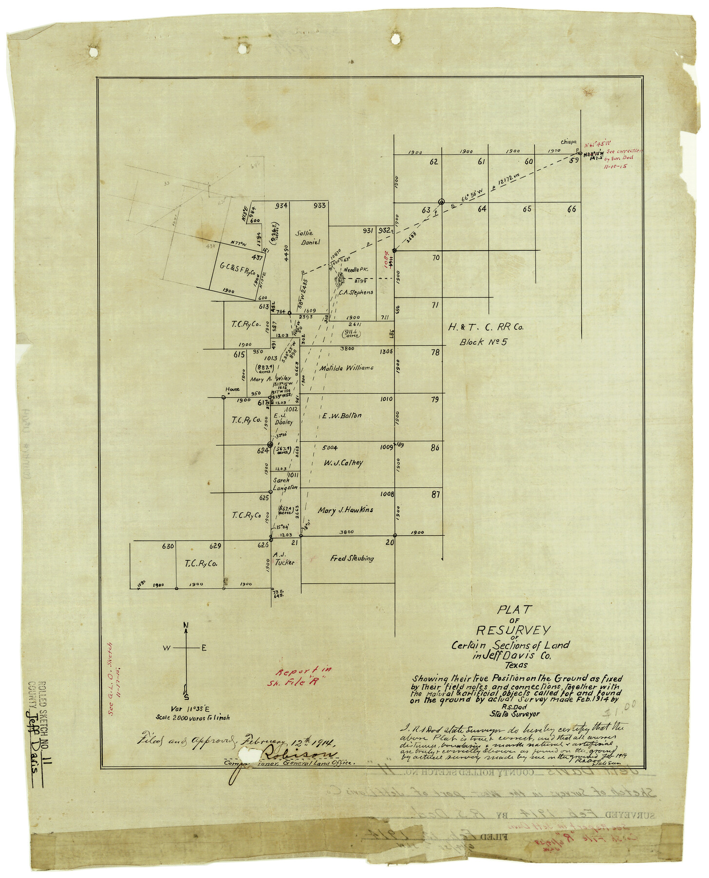
Jeff Davis County Rolled Sketch 11
Plat of resurvey of certain sections of land in Jeff Davis Co., Texas showing their true position on the ground as fixed by their field notes and connections, together with the natural & artificial objects called for and found on the ground
-
Map/Doc
6364
-
Collection
General Map Collection
-
Object Dates
2/1914 (Creation Date)
2/12/1914 (File Date)
-
People and Organizations
R.S. Dod (Surveyor/Engineer)
-
Counties
Jeff Davis
-
Subjects
Surveying Rolled Sketch
-
Height x Width
17.9 x 14.4 inches
45.5 x 36.6 cm
-
Medium
linen, manuscript
-
Scale
1" = 2000 varas
-
Comments
See Jeff Davis County Sketch File R (28017) for report.
Related maps
Jeff Davis County Sketch File R

Print $12.00
- Digital $50.00
Jeff Davis County Sketch File R
Size 6.0 x 8.7 inches
Map/Doc 28017
Part of: General Map Collection
Map of Falls County

Print $20.00
- Digital $50.00
Map of Falls County
1874
Size 20.3 x 21.5 inches
Map/Doc 3528
Right of Way and Track Map, the Missouri, Kansas and Texas Ry. of Texas - Henrietta Division

Print $20.00
- Digital $50.00
Right of Way and Track Map, the Missouri, Kansas and Texas Ry. of Texas - Henrietta Division
1918
Size 11.8 x 26.9 inches
Map/Doc 64754

Rockwall County Sketch File 8

Print $4.00
Rockwall County Sketch File 8
Size 7.1 x 10.6 inches
Map/Doc 35429
Pecos County Working Sketch 71

Print $20.00
- Digital $50.00
Pecos County Working Sketch 71
1957
Size 41.6 x 26.0 inches
Map/Doc 71543
Jeff Davis County Rolled Sketch 20

Print $20.00
- Digital $50.00
Jeff Davis County Rolled Sketch 20
1944
Size 22.7 x 19.6 inches
Map/Doc 7724
[Right of Way & Track Map, The Texas & Pacific Ry. Co. Main Line]
![64666, [Right of Way & Track Map, The Texas & Pacific Ry. Co. Main Line], General Map Collection](https://historictexasmaps.com/wmedia_w700/maps/64666.tif.jpg)
Print $20.00
- Digital $50.00
[Right of Way & Track Map, The Texas & Pacific Ry. Co. Main Line]
Size 11.0 x 18.5 inches
Map/Doc 64666
Madison County Working Sketch 15

Print $20.00
- Digital $50.00
Madison County Working Sketch 15
2009
Size 42.3 x 36.0 inches
Map/Doc 89019
Colorado County Sketch File 21

Print $8.00
- Digital $50.00
Colorado County Sketch File 21
Size 13.1 x 8.8 inches
Map/Doc 18957
Colorado River, Shoal Creek from 12th to 34th Street/Austin, Texas

Print $40.00
- Digital $50.00
Colorado River, Shoal Creek from 12th to 34th Street/Austin, Texas
1929
Size 61.5 x 28.6 inches
Map/Doc 65327
Pecos County Sketch File 24

Print $22.00
- Digital $50.00
Pecos County Sketch File 24
Size 7.6 x 5.6 inches
Map/Doc 33680
Map of the Houston and Great Northern R.R. from Trinity River to Palestine

Print $40.00
- Digital $50.00
Map of the Houston and Great Northern R.R. from Trinity River to Palestine
1872
Size 30.3 x 119.9 inches
Map/Doc 64549
You may also like
Travis County Appraisal District Plat Map 3_0404

Print $20.00
- Digital $50.00
Travis County Appraisal District Plat Map 3_0404
Size 21.5 x 26.4 inches
Map/Doc 94226
El Paso County Sketch File 35 (6)

Print $20.00
- Digital $50.00
El Paso County Sketch File 35 (6)
1886
Size 20.3 x 36.9 inches
Map/Doc 11460
![90772, [Block XR], Twichell Survey Records](https://historictexasmaps.com/wmedia_w700/maps/90772-1.tif.jpg)
Reagan County Sketch File 7

Print $6.00
- Digital $50.00
Reagan County Sketch File 7
1928
Size 11.2 x 8.7 inches
Map/Doc 34986
San Patricio County Rolled Sketch 52

Print $20.00
- Digital $50.00
San Patricio County Rolled Sketch 52
1994
Size 36.7 x 39.4 inches
Map/Doc 7737
Flight Mission No. DAG-23K, Frame 143, Matagorda County

Print $20.00
- Digital $50.00
Flight Mission No. DAG-23K, Frame 143, Matagorda County
1953
Size 15.8 x 15.7 inches
Map/Doc 86491
Sketch of Crosby Co.

Print $20.00
- Digital $50.00
Sketch of Crosby Co.
1884
Size 14.8 x 12.5 inches
Map/Doc 506
Motley County Sketch File DD (S)

Print $22.00
- Digital $50.00
Motley County Sketch File DD (S)
Size 10.9 x 7.1 inches
Map/Doc 32159
Presidio County Rolled Sketch T-4

Print $20.00
- Digital $50.00
Presidio County Rolled Sketch T-4
1949
Size 32.1 x 15.7 inches
Map/Doc 7418
Map of San Gabriel & Lampassas [sic] Surveys
![58, Map of San Gabriel & Lampassas [sic] Surveys, General Map Collection](https://historictexasmaps.com/wmedia_w700/maps/58.tif.jpg)
Print $20.00
- Digital $50.00
Map of San Gabriel & Lampassas [sic] Surveys
1841
Size 29.0 x 20.0 inches
Map/Doc 58
Erath County Working Sketch 31

Print $20.00
- Digital $50.00
Erath County Working Sketch 31
1970
Size 23.2 x 26.2 inches
Map/Doc 69112
Edwards County Boundary File 29

Print $22.00
- Digital $50.00
Edwards County Boundary File 29
Size 15.4 x 31.0 inches
Map/Doc 65502