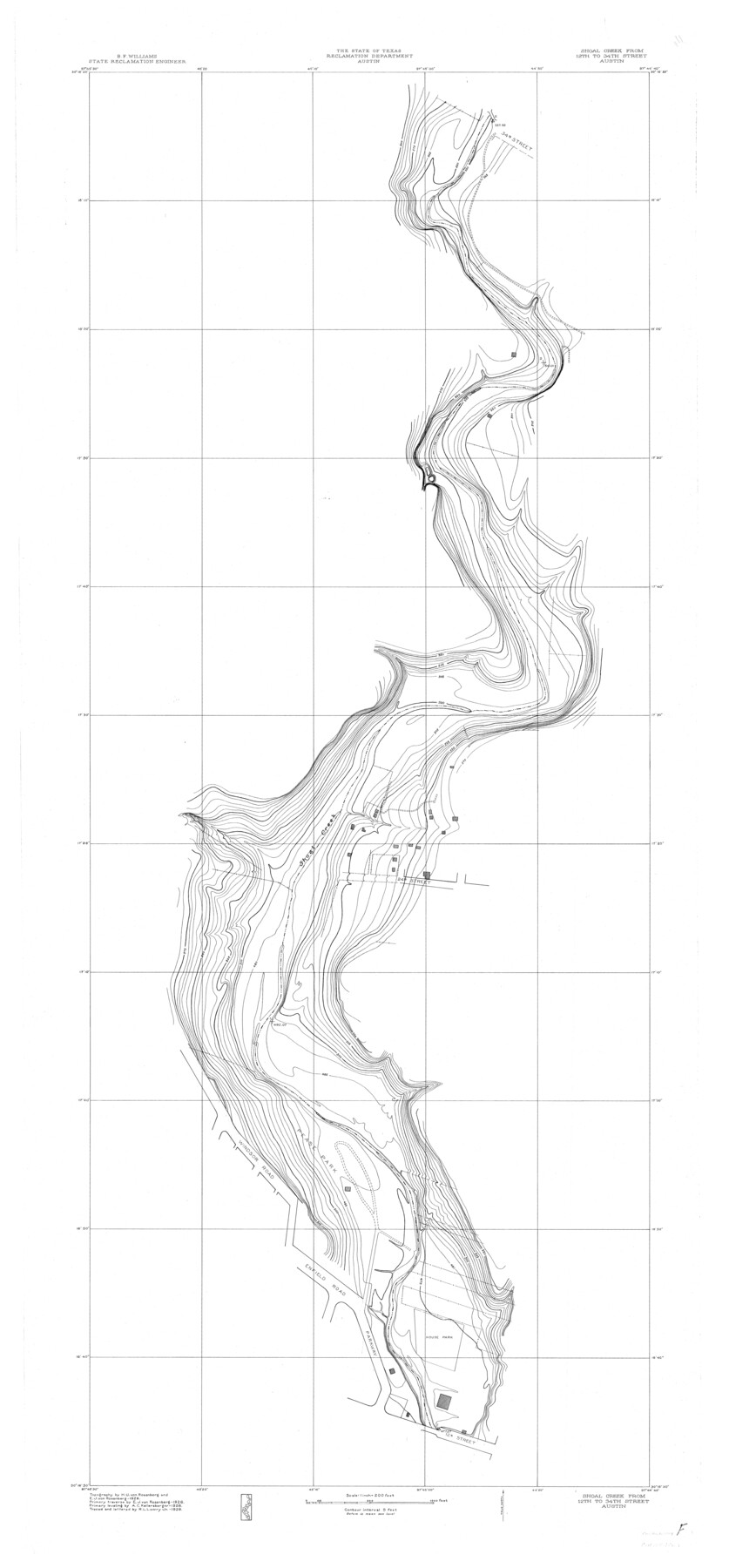
Colorado River, Shoal Creek from 12th to 34th Street/Austin, Texas
-
Map/Doc
65327
-
Collection
General Map Collection
-
Object Dates
1929 (Creation Date)
-
People and Organizations
Texas State Reclamation Department (Publisher)
R.L. Lowry Jr. (Compiler)
R.L. Lowry Jr. (Draftsman)
E.J. von Rosenberg (Surveyor/Engineer)
A.C. Kellersberger (Surveyor/Engineer)
H.U. von Rosenberg (Surveyor/Engineer)
-
Counties
Travis
-
Subjects
City River Surveys Topographic
-
Height x Width
61.5 x 28.6 inches
156.2 x 72.6 cm
Part of: General Map Collection
Nacogdoches County Rolled Sketch 3

Print $20.00
- Digital $50.00
Nacogdoches County Rolled Sketch 3
1985
Size 39.6 x 27.6 inches
Map/Doc 6837
Real County Working Sketch 48

Print $20.00
- Digital $50.00
Real County Working Sketch 48
1956
Size 29.4 x 18.5 inches
Map/Doc 71940
Brown County Rolled Sketch 2C

Print $20.00
- Digital $50.00
Brown County Rolled Sketch 2C
1984
Size 26.7 x 24.6 inches
Map/Doc 5352
Val Verde County Working Sketch 36

Print $20.00
- Digital $50.00
Val Verde County Working Sketch 36
1942
Size 34.5 x 44.9 inches
Map/Doc 72171
Hood County Working Sketch 31

Print $20.00
- Digital $50.00
Hood County Working Sketch 31
1998
Size 33.6 x 35.8 inches
Map/Doc 66225
Lines of Equal Magnetic Declination and of Equal Annual Change in the United States for 1930

Print $20.00
- Digital $50.00
Lines of Equal Magnetic Declination and of Equal Annual Change in the United States for 1930
1930
Size 23.5 x 29.7 inches
Map/Doc 69652
La Salle County Sketch File 20A

Print $29.00
- Digital $50.00
La Salle County Sketch File 20A
1852
Size 19.5 x 33.6 inches
Map/Doc 11984
Jefferson County NRC Article 33.136 Sketch 13

Print $164.00
- Digital $50.00
Jefferson County NRC Article 33.136 Sketch 13
2019
Size 22.2 x 35.0 inches
Map/Doc 96447
Marion County Working Sketch 1

Print $20.00
- Digital $50.00
Marion County Working Sketch 1
Size 15.2 x 23.3 inches
Map/Doc 70776
Mexico Comision Pesquisidora de la Frontera del Norte

Mexico Comision Pesquisidora de la Frontera del Norte
1874
Map/Doc 97125
Flight Mission No. BRA-7M, Frame 28, Jefferson County

Print $20.00
- Digital $50.00
Flight Mission No. BRA-7M, Frame 28, Jefferson County
1953
Size 18.5 x 22.4 inches
Map/Doc 85479
Goliad County Working Sketch 1

Print $20.00
- Digital $50.00
Goliad County Working Sketch 1
Size 23.7 x 39.9 inches
Map/Doc 63191
You may also like
Val Verde County Rolled Sketch 39

Print $20.00
- Digital $50.00
Val Verde County Rolled Sketch 39
Size 21.7 x 33.9 inches
Map/Doc 8115
Galveston Bay Texas Lower Part Encluding [sic] Bar and Entrance
![69869, Galveston Bay Texas Lower Part Encluding [sic] Bar and Entrance, General Map Collection](https://historictexasmaps.com/wmedia_w700/maps/69869-1.tif.jpg)
Print $40.00
- Digital $50.00
Galveston Bay Texas Lower Part Encluding [sic] Bar and Entrance
1867
Size 52.6 x 39.1 inches
Map/Doc 69869
Waller County Sketch File 1a

Print $20.00
- Digital $50.00
Waller County Sketch File 1a
Size 25.4 x 16.6 inches
Map/Doc 12598
Brazos River, Brazos River Sheet 1

Print $20.00
- Digital $50.00
Brazos River, Brazos River Sheet 1
1926
Size 20.7 x 25.3 inches
Map/Doc 69665
Edwards County Sketch File 31

Print $6.00
- Digital $50.00
Edwards County Sketch File 31
1926
Size 14.5 x 8.8 inches
Map/Doc 21762
Map of Brown County

Print $20.00
- Digital $50.00
Map of Brown County
1876
Size 25.9 x 23.3 inches
Map/Doc 3341
Flight Mission No. BRA-16M, Frame 161, Jefferson County

Print $20.00
- Digital $50.00
Flight Mission No. BRA-16M, Frame 161, Jefferson County
1953
Size 18.5 x 22.3 inches
Map/Doc 85759
Map of Caldwell County, Texas

Print $20.00
Map of Caldwell County, Texas
1880
Size 18.7 x 22.0 inches
Map/Doc 88915
Map of Robertson County

Print $20.00
- Digital $50.00
Map of Robertson County
1888
Size 29.1 x 23.9 inches
Map/Doc 83004
Austin County Rolled Sketch 7

Print $47.00
- Digital $50.00
Austin County Rolled Sketch 7
1974
Size 10.4 x 15.3 inches
Map/Doc 42340
Aransas County Boundary File 3

Print $16.00
- Digital $50.00
Aransas County Boundary File 3
Size 10.6 x 8.0 inches
Map/Doc 49782
[PSL Blocks A, 38, 40, 51-57, B-1 and C and T. & P. Block 46, Township 1N]
![93149, [PSL Blocks A, 38, 40, 51-57, B-1 and C and T. & P. Block 46, Township 1N], Twichell Survey Records](https://historictexasmaps.com/wmedia_w700/maps/93149-1.tif.jpg)
Print $40.00
- Digital $50.00
[PSL Blocks A, 38, 40, 51-57, B-1 and C and T. & P. Block 46, Township 1N]
Size 23.8 x 84.4 inches
Map/Doc 93149