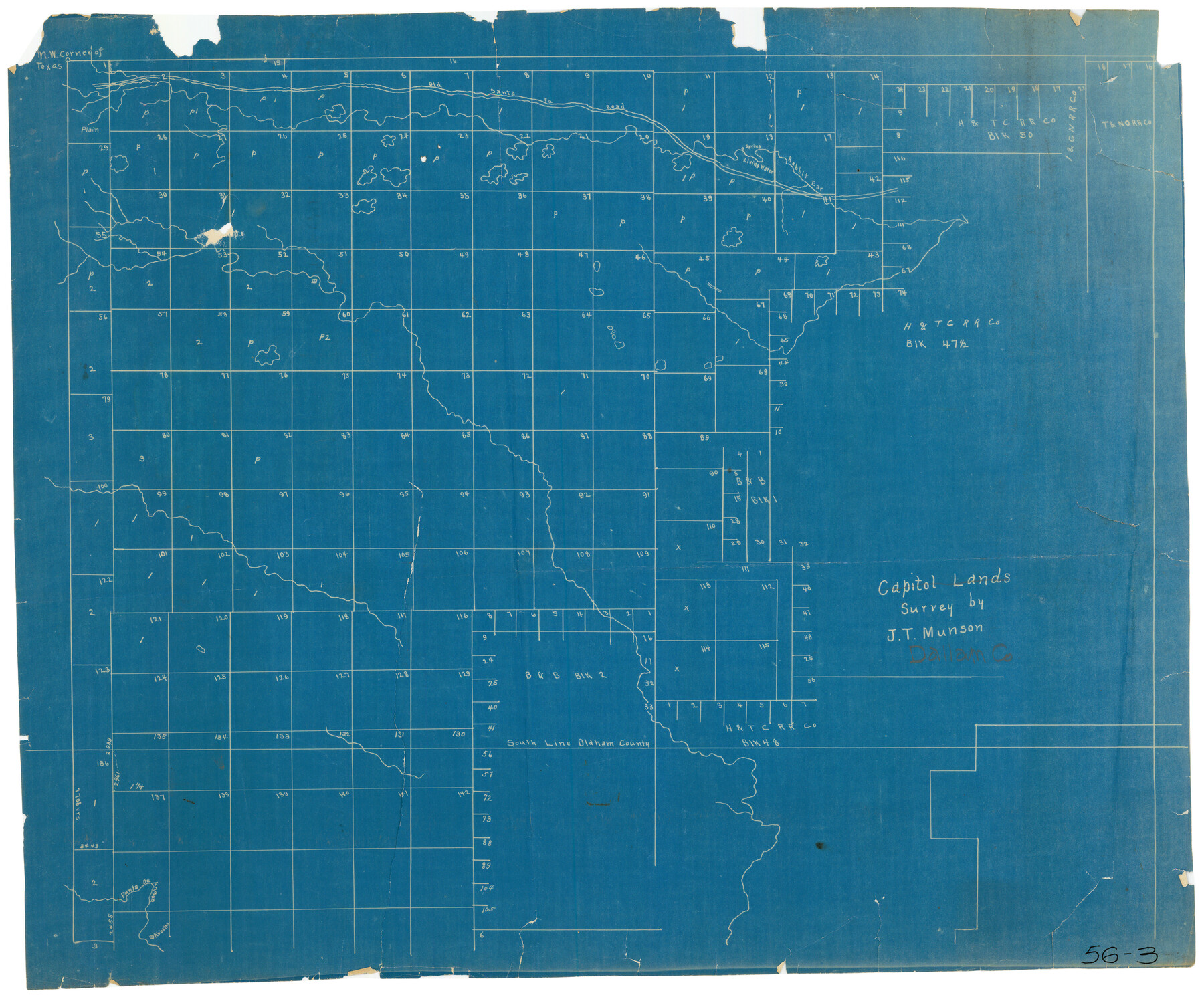
Capitol Lands survey by J. T. Munson
56-3
-
Map/Doc
90585
-
Collection
Twichell Survey Records
-
People and Organizations
J.T. Munson (Surveyor/Engineer)
-
Counties
Dallam
-
Height x Width
24.8 x 20.4 inches
63.0 x 51.8 cm
Part of: Twichell Survey Records
[W. T. Brewer: M. McDonald, Ralph Gilpin, A. Vanhooser, John Baker, John R. Taylor Surveys]
![90962, [W. T. Brewer: M. McDonald, Ralph Gilpin, A. Vanhooser, John Baker, John R. Taylor Surveys], Twichell Survey Records](https://historictexasmaps.com/wmedia_w700/maps/90962-1.tif.jpg)
Print $2.00
- Digital $50.00
[W. T. Brewer: M. McDonald, Ralph Gilpin, A. Vanhooser, John Baker, John R. Taylor Surveys]
Size 9.2 x 11.4 inches
Map/Doc 90962
[North part] Cass County
![90385, [North part] Cass County, Twichell Survey Records](https://historictexasmaps.com/wmedia_w700/maps/90385-1.tif.jpg)
Print $20.00
- Digital $50.00
[North part] Cass County
1896
Size 37.3 x 19.5 inches
Map/Doc 90385
Jarrott Ranch Yeso, New Mexico

Print $20.00
- Digital $50.00
Jarrott Ranch Yeso, New Mexico
Size 26.3 x 19.8 inches
Map/Doc 92423
[Map showing Block 35, Townships 1N-5N]
![93207, [Map showing Block 35, Townships 1N-5N], Twichell Survey Records](https://historictexasmaps.com/wmedia_w700/maps/93207-1.tif.jpg)
Print $40.00
- Digital $50.00
[Map showing Block 35, Townships 1N-5N]
Size 22.8 x 83.0 inches
Map/Doc 93207
[Connections of Blocks C-17, B-59, T6 and C-11]
![93067, [Connections of Blocks C-17, B-59, T6 and C-11], Twichell Survey Records](https://historictexasmaps.com/wmedia_w700/maps/93067-1.tif.jpg)
Print $20.00
- Digital $50.00
[Connections of Blocks C-17, B-59, T6 and C-11]
Size 31.2 x 28.0 inches
Map/Doc 93067
[Sketch showing position of 287.2 acres of land surveyed for W. D. Twichell]
![91904, [Sketch showing position of 287.2 acres of land surveyed for W. D. Twichell], Twichell Survey Records](https://historictexasmaps.com/wmedia_w700/maps/91904-2.tif.jpg)
Print $2.00
- Digital $50.00
[Sketch showing position of 287.2 acres of land surveyed for W. D. Twichell]
1919
Size 15.2 x 7.3 inches
Map/Doc 91904
[Blocks T1, T2, T3, S3, A, 05, 02 and vicinity]
![92196, [Blocks T1, T2, T3, S3, A, 05, 02 and vicinity], Twichell Survey Records](https://historictexasmaps.com/wmedia_w700/maps/92196-1.tif.jpg)
Print $20.00
- Digital $50.00
[Blocks T1, T2, T3, S3, A, 05, 02 and vicinity]
Size 20.3 x 22.9 inches
Map/Doc 92196
[H. & G. N. Block 1]
![90939, [H. & G. N. Block 1], Twichell Survey Records](https://historictexasmaps.com/wmedia_w700/maps/90939-1.tif.jpg)
Print $20.00
- Digital $50.00
[H. & G. N. Block 1]
1902
Size 13.5 x 16.4 inches
Map/Doc 90939
[Sketch showing PSL Blocks A13, A25-A27, A30-A32, A37, A38, A47-A49 & N/L Univ. Blk. 11]
![89738, [Sketch showing PSL Blocks A13, A25-A27, A30-A32, A37, A38, A47-A49 & N/L Univ. Blk. 11], Twichell Survey Records](https://historictexasmaps.com/wmedia_w700/maps/89738-1.tif.jpg)
Print $40.00
- Digital $50.00
[Sketch showing PSL Blocks A13, A25-A27, A30-A32, A37, A38, A47-A49 & N/L Univ. Blk. 11]
Size 23.6 x 62.4 inches
Map/Doc 89738
[Sketch of sections 33 and 34]
![91575, [Sketch of sections 33 and 34], Twichell Survey Records](https://historictexasmaps.com/wmedia_w700/maps/91575-1.tif.jpg)
Print $2.00
- Digital $50.00
[Sketch of sections 33 and 34]
Size 5.0 x 8.7 inches
Map/Doc 91575
Sheet 2 copied from Peck Book 6 [Strip Map showing T. & P. connecting lines]
![93172, Sheet 2 copied from Peck Book 6 [Strip Map showing T. & P. connecting lines], Twichell Survey Records](https://historictexasmaps.com/wmedia_w700/maps/93172-1.tif.jpg)
Print $40.00
- Digital $50.00
Sheet 2 copied from Peck Book 6 [Strip Map showing T. & P. connecting lines]
1909
Size 6.5 x 53.9 inches
Map/Doc 93172

You may also like
Tom Green County Sketch File 38

Print $20.00
- Digital $50.00
Tom Green County Sketch File 38
Size 13.7 x 23.0 inches
Map/Doc 12438
Live Oak County Sketch File 34

Print $28.00
- Digital $50.00
Live Oak County Sketch File 34
1963
Size 31.0 x 23.9 inches
Map/Doc 12011
Sketch No. 2 Showing Land Ties with Houston & Texas Central Rail Road through Harris County, Texas

Print $20.00
- Digital $50.00
Sketch No. 2 Showing Land Ties with Houston & Texas Central Rail Road through Harris County, Texas
1880
Size 8.5 x 26.9 inches
Map/Doc 64496
Stonewall County Working Sketch Graphic Index - sheet B

Print $20.00
- Digital $50.00
Stonewall County Working Sketch Graphic Index - sheet B
1933
Size 43.7 x 36.6 inches
Map/Doc 83172
Outer Continental Shelf Leasing Map, Texas

Print $20.00
- Digital $50.00
Outer Continental Shelf Leasing Map, Texas
1954
Size 17.3 x 22.2 inches
Map/Doc 75832
Tarrant County Working Sketch 13

Print $20.00
- Digital $50.00
Tarrant County Working Sketch 13
1987
Size 22.4 x 30.8 inches
Map/Doc 62430
Collingsworth County

Print $20.00
- Digital $50.00
Collingsworth County
1971
Size 40.7 x 34.2 inches
Map/Doc 77243
[Sketch of part of Blks. B5, 6, 2Z, M6, M8, M11 and M15]
![89644, [Sketch of part of Blks. B5, 6, 2Z, M6, M8, M11 and M15], Twichell Survey Records](https://historictexasmaps.com/wmedia_w700/maps/89644-1.tif.jpg)
Print $40.00
- Digital $50.00
[Sketch of part of Blks. B5, 6, 2Z, M6, M8, M11 and M15]
Size 18.6 x 62.0 inches
Map/Doc 89644
Walker County Sketch File 6

Print $4.00
- Digital $50.00
Walker County Sketch File 6
1876
Size 8.1 x 6.1 inches
Map/Doc 39557
[Block T2, Lamb County]
![90969, [Block T2, Lamb County], Twichell Survey Records](https://historictexasmaps.com/wmedia_w700/maps/90969-1.tif.jpg)
Print $2.00
- Digital $50.00
[Block T2, Lamb County]
Size 11.2 x 8.7 inches
Map/Doc 90969
Hardeman County Sketch File 12

Print $4.00
- Digital $50.00
Hardeman County Sketch File 12
Size 12.8 x 8.3 inches
Map/Doc 25020
