Hays County State Real Property Sketch 1
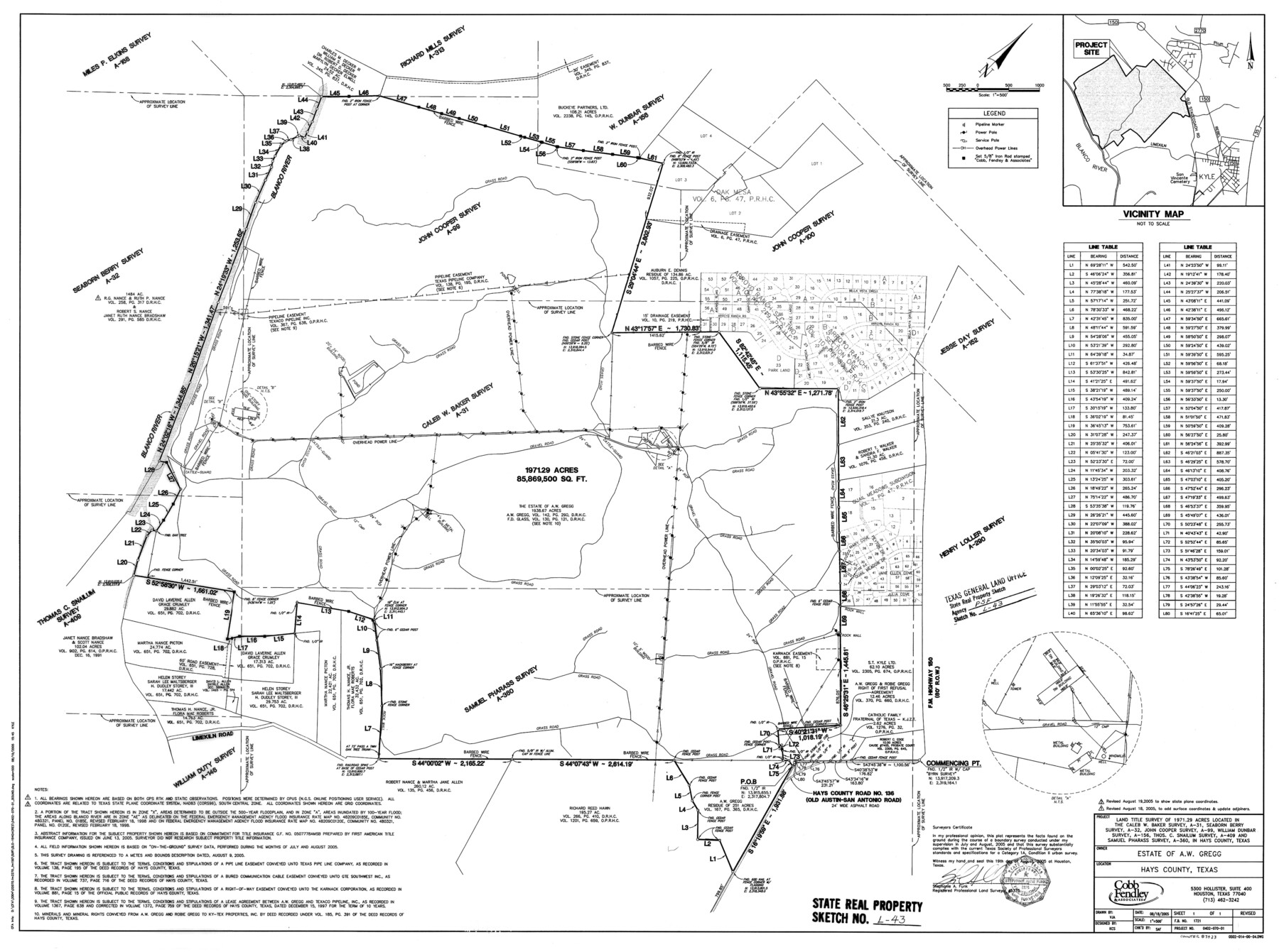
A Land Title Survey of 1971.29 Acres Located in the Caleb W. Baker Survey, A - 31, Seaborn Berry Survey, A - 32, John Cooper Survey, A - 99, William Dunbar Survey, A - 156, Thos. C. Snailum Survey, A - 409, and Samuel Pharass Survey, A - 360
State Real Property Sketch L - 43
-
Map/Doc
83423
-
Collection
General Map Collection
-
Object Dates
2005/8/18 (Creation Date)
2005/12/28 (File Date)
-
People and Organizations
Cobb Fendley & Associates (Publisher)
Cobb Fendley & Associates (Printer)
VJA (Draftsman)
KCS (Compiler)
Stephanie A. Funk (Surveyor/Engineer)
-
Counties
Hays
-
Subjects
State Real Property
-
Height x Width
31.1 x 42.2 inches
79.0 x 107.2 cm
-
Comments
Surveys of the estate of A. W. Gregg located about eight miles North 12 degrees East of San Marcos, Texas.
Part of: General Map Collection
The Coast of Texas

Print $20.00
- Digital $50.00
The Coast of Texas
1844
Size 18.2 x 27.0 inches
Map/Doc 72700
Foard County Working Sketch 10

Print $20.00
- Digital $50.00
Foard County Working Sketch 10
1977
Size 32.0 x 43.7 inches
Map/Doc 69201
Uvalde County Working Sketch 34

Print $20.00
- Digital $50.00
Uvalde County Working Sketch 34
1963
Size 31.6 x 42.8 inches
Map/Doc 72104
Flight Mission No. DQO-2K, Frame 135, Galveston County

Print $20.00
- Digital $50.00
Flight Mission No. DQO-2K, Frame 135, Galveston County
1952
Size 18.7 x 22.5 inches
Map/Doc 85032
Hispania Nova

Print $20.00
- Digital $50.00
Hispania Nova
1597
Size 12.0 x 14.9 inches
Map/Doc 94120
Tom Green County Sketch File 55 1/2

Print $20.00
- Digital $50.00
Tom Green County Sketch File 55 1/2
1886
Size 26.4 x 13.6 inches
Map/Doc 12443
Flight Mission No. DQN-1K, Frame 151, Calhoun County

Print $20.00
- Digital $50.00
Flight Mission No. DQN-1K, Frame 151, Calhoun County
1953
Size 18.6 x 22.3 inches
Map/Doc 84210
Flight Mission No. DQN-2K, Frame 5, Calhoun County

Print $20.00
- Digital $50.00
Flight Mission No. DQN-2K, Frame 5, Calhoun County
1953
Size 18.5 x 22.2 inches
Map/Doc 84222
Map of Comal County

Print $20.00
- Digital $50.00
Map of Comal County
1897
Size 40.4 x 46.3 inches
Map/Doc 4917
Harris County Working Sketch 4

Print $20.00
- Digital $50.00
Harris County Working Sketch 4
Size 20.7 x 26.6 inches
Map/Doc 65896
Flight Mission No. CGI-1N, Frame 221, Cameron County

Print $20.00
- Digital $50.00
Flight Mission No. CGI-1N, Frame 221, Cameron County
1955
Size 18.5 x 22.2 inches
Map/Doc 84530
McMullen County Sketch File 13

Print $4.00
- Digital $50.00
McMullen County Sketch File 13
1876
Size 10.0 x 8.0 inches
Map/Doc 31359
You may also like
Flight Mission No. CGI-3N, Frame 111, Cameron County

Print $20.00
- Digital $50.00
Flight Mission No. CGI-3N, Frame 111, Cameron County
1954
Size 18.6 x 22.2 inches
Map/Doc 84591
Coast Chart No. 210 Aransas Pass and Corpus Christi Bay with the coast to latitude 27° 12' Texas

Print $20.00
- Digital $50.00
Coast Chart No. 210 Aransas Pass and Corpus Christi Bay with the coast to latitude 27° 12' Texas
1913
Size 27.4 x 18.3 inches
Map/Doc 72797
Montgomery County Working Sketch 12

Print $20.00
- Digital $50.00
Montgomery County Working Sketch 12
1933
Size 32.5 x 31.9 inches
Map/Doc 71119
New Birmingham, Cherokee County, Texas

Print $20.00
- Digital $50.00
New Birmingham, Cherokee County, Texas
1891
Size 23.1 x 19.2 inches
Map/Doc 96617
Brewster County Sketch File S-26

Print $8.00
- Digital $50.00
Brewster County Sketch File S-26
1963
Size 11.1 x 8.8 inches
Map/Doc 15833
Refugio County Sketch File 8b

Print $4.00
- Digital $50.00
Refugio County Sketch File 8b
1876
Size 8.5 x 10.5 inches
Map/Doc 35254
Flight Mission No. CRC-2R, Frame 60, Chambers County

Print $20.00
- Digital $50.00
Flight Mission No. CRC-2R, Frame 60, Chambers County
1956
Size 18.4 x 22.3 inches
Map/Doc 84731
Menard County Working Sketch 32

Print $20.00
- Digital $50.00
Menard County Working Sketch 32
1987
Size 35.8 x 33.8 inches
Map/Doc 70979
Fort Bend County Working Sketch 2

Print $20.00
- Digital $50.00
Fort Bend County Working Sketch 2
1897
Size 18.3 x 28.4 inches
Map/Doc 69208
Whitehead Addition, City of Lubbock

Print $20.00
- Digital $50.00
Whitehead Addition, City of Lubbock
Size 17.9 x 24.6 inches
Map/Doc 92779
Culberson County Sketch File WJ2

Print $20.00
- Digital $50.00
Culberson County Sketch File WJ2
Size 15.5 x 20.3 inches
Map/Doc 5788
Yoakum County Sketch File 13

Print $49.00
- Digital $50.00
Yoakum County Sketch File 13
1898
Size 8.3 x 8.6 inches
Map/Doc 40767