Brewster County Sketch File S-26
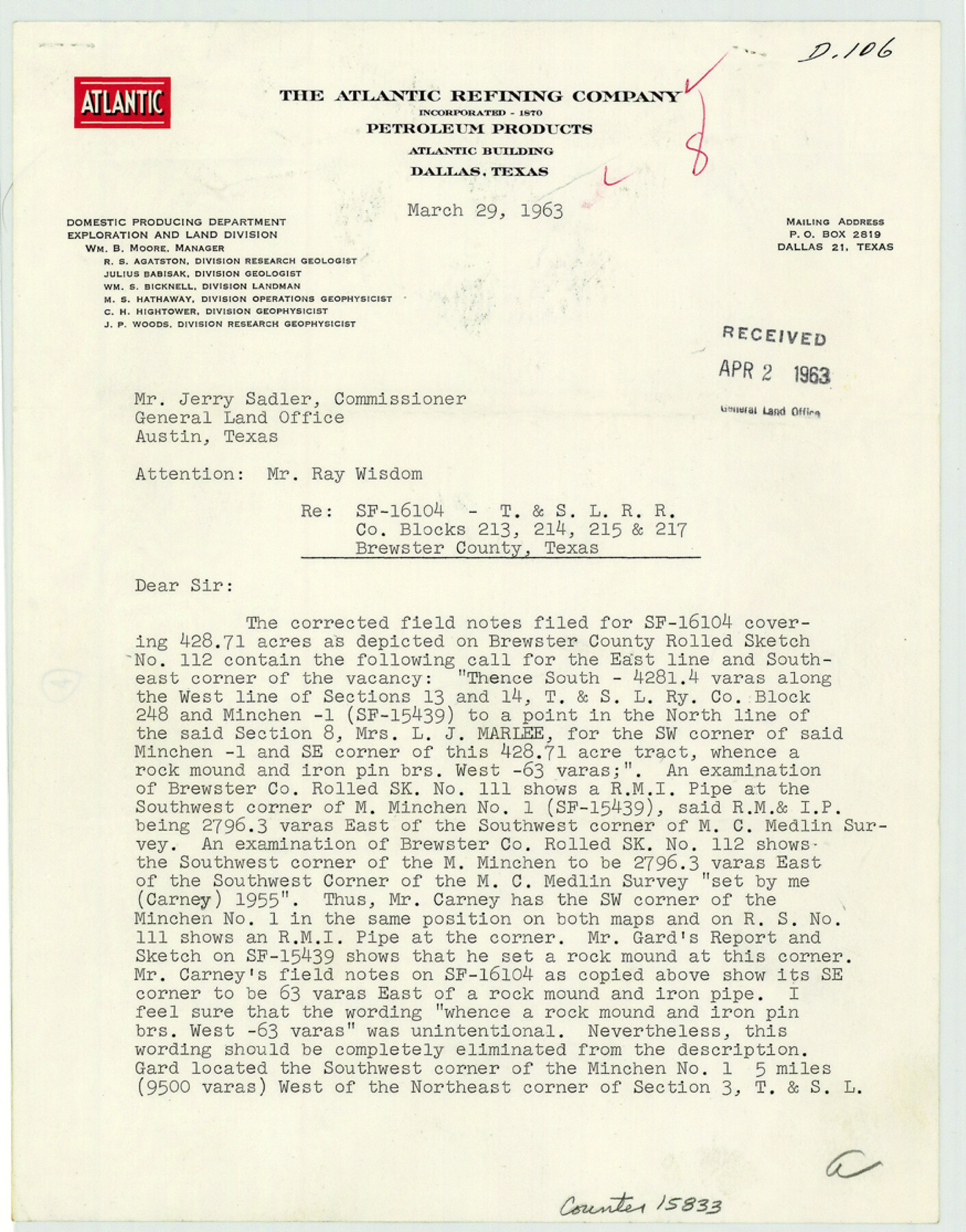
[Protest letter from W.J. Burkart with the Atlantic Refining Company regarding SF-16104 - T. & St. L. R.R. Co. Blocks 213, 214, 215, and 217]
-
Map/Doc
15833
-
Collection
General Map Collection
-
Object Dates
1963/3/29 (Creation Date)
1963/4/2 (File Date)
-
People and Organizations
W.J. Burkart (Surveyor/Engineer)
-
Counties
Brewster
-
Subjects
Surveying Sketch File
-
Height x Width
11.1 x 8.8 inches
28.2 x 22.4 cm
-
Medium
paper, print
Part of: General Map Collection
Red River County Red River District

Print $20.00
- Digital $50.00
Red River County Red River District
1879
Size 24.9 x 21.8 inches
Map/Doc 3976
Starr County Sketch File 49

Print $20.00
- Digital $50.00
Starr County Sketch File 49
1951
Size 24.9 x 17.2 inches
Map/Doc 12346
Lampasas County Working Sketch 22

Print $20.00
- Digital $50.00
Lampasas County Working Sketch 22
1993
Size 34.5 x 34.7 inches
Map/Doc 70300
Titus County Working Sketch 7

Print $20.00
- Digital $50.00
Titus County Working Sketch 7
1970
Size 31.5 x 28.7 inches
Map/Doc 69368
Milam County Rolled Sketch 5

Print $20.00
- Digital $50.00
Milam County Rolled Sketch 5
Size 27.9 x 39.8 inches
Map/Doc 6777
Williamson County Working Sketch 11

Print $20.00
- Digital $50.00
Williamson County Working Sketch 11
1961
Size 37.3 x 36.2 inches
Map/Doc 72571
Karnes County Working Sketch 11

Print $40.00
- Digital $50.00
Karnes County Working Sketch 11
1975
Size 38.1 x 53.6 inches
Map/Doc 66659
San Saba County Sketch File 14b

Print $8.00
- Digital $50.00
San Saba County Sketch File 14b
1899
Size 14.3 x 8.9 inches
Map/Doc 36448
Montague County Working Sketch 41

Print $40.00
- Digital $50.00
Montague County Working Sketch 41
1923
Size 43.0 x 66.1 inches
Map/Doc 65349
Concho County Sketch File 5

Print $2.00
- Digital $50.00
Concho County Sketch File 5
1858
Size 8.1 x 7.4 inches
Map/Doc 82974
Hutchinson County Working Sketch 44

Print $20.00
- Digital $50.00
Hutchinson County Working Sketch 44
1978
Size 27.6 x 23.4 inches
Map/Doc 66404
Aransas County Boundary File 2

Print $3.00
- Digital $50.00
Aransas County Boundary File 2
Size 12.4 x 10.8 inches
Map/Doc 49781
You may also like
Lampasas County Working Sketch 23

Print $20.00
- Digital $50.00
Lampasas County Working Sketch 23
2000
Size 22.9 x 36.8 inches
Map/Doc 70301
Flight Mission No. CRC-3R, Frame 202, Chambers County

Print $20.00
- Digital $50.00
Flight Mission No. CRC-3R, Frame 202, Chambers County
1956
Size 18.7 x 22.4 inches
Map/Doc 84857
Harris County Sketch File 88

Print $171.00
- Digital $50.00
Harris County Sketch File 88
1914
Size 13.8 x 12.1 inches
Map/Doc 25555

Crockett County Working Sketch 53

Print $20.00
- Digital $50.00
Crockett County Working Sketch 53
1948
Size 24.2 x 27.7 inches
Map/Doc 68386
[Shelby District]
![69740, [Shelby District], General Map Collection](https://historictexasmaps.com/wmedia_w700/maps/69740.tif.jpg)
Print $2.00
- Digital $50.00
[Shelby District]
1845
Size 6.9 x 7.6 inches
Map/Doc 69740
Hardeman County Working Sketch 13

Print $20.00
- Digital $50.00
Hardeman County Working Sketch 13
1966
Size 35.8 x 45.7 inches
Map/Doc 63394
Castro County Sketch File 8

Print $20.00
- Digital $50.00
Castro County Sketch File 8
1908
Size 27.2 x 24.0 inches
Map/Doc 11060
Flight Mission No. DCL-5C, Frame 72, Kenedy County

Print $20.00
- Digital $50.00
Flight Mission No. DCL-5C, Frame 72, Kenedy County
1943
Size 18.7 x 22.5 inches
Map/Doc 85855
Sutton County Sketch File 52

Print $6.00
- Digital $50.00
Sutton County Sketch File 52
1948
Size 11.2 x 8.8 inches
Map/Doc 37529
Montague County Working Sketch 35

Print $20.00
- Digital $50.00
Montague County Working Sketch 35
1980
Size 24.8 x 31.9 inches
Map/Doc 71101
Pecos County Rolled Sketch 70

Print $40.00
- Digital $50.00
Pecos County Rolled Sketch 70
1929
Size 49.3 x 21.6 inches
Map/Doc 9708