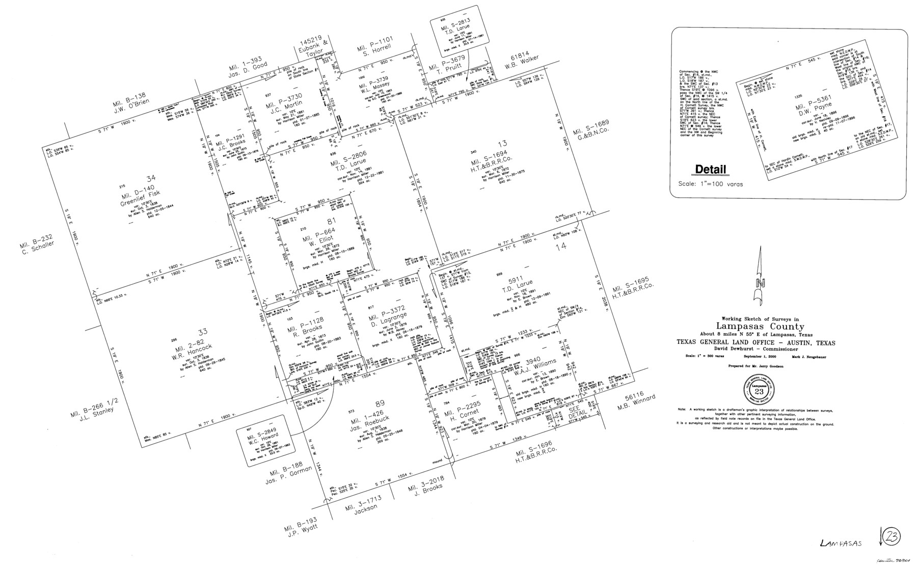
Lampasas County Working Sketch 23
-
Map/Doc
70301
-
Collection
General Map Collection
-
Object Dates
9/1/2000 (Creation Date)
-
People and Organizations
Mark Neugebauer (Draftsman)
-
Counties
Lampasas
-
Subjects
Surveying Working Sketch
-
Height x Width
22.9 x 36.8 inches
58.2 x 93.5 cm
-
Scale
1" = 300 varas
Part of: General Map Collection
Right of Way & Track Map, St. Louis, Brownsville & Mexico Ry. operated by St. Louis, Brownsville & Mexico Ry. Co.

Print $40.00
- Digital $50.00
Right of Way & Track Map, St. Louis, Brownsville & Mexico Ry. operated by St. Louis, Brownsville & Mexico Ry. Co.
1919
Size 25.4 x 57.2 inches
Map/Doc 64621
Flight Mission No. DIX-6P, Frame 130, Aransas County

Print $20.00
- Digital $50.00
Flight Mission No. DIX-6P, Frame 130, Aransas County
1956
Size 19.3 x 22.9 inches
Map/Doc 83836
La Salle County Working Sketch 32

Print $20.00
- Digital $50.00
La Salle County Working Sketch 32
1955
Size 35.8 x 27.1 inches
Map/Doc 70333
Calhoun County Rolled Sketch 28B

Print $7.00
- Digital $50.00
Calhoun County Rolled Sketch 28B
1834
Size 10.5 x 15.4 inches
Map/Doc 43684
Bee County Working Sketch 2

Print $3.00
- Digital $50.00
Bee County Working Sketch 2
1914
Size 11.0 x 9.6 inches
Map/Doc 67252
Presidio County Working Sketch 82

Print $40.00
- Digital $50.00
Presidio County Working Sketch 82
1967
Size 48.6 x 67.2 inches
Map/Doc 71759
Harris County Sketch File C

Print $4.00
- Digital $50.00
Harris County Sketch File C
1866
Size 5.9 x 9.8 inches
Map/Doc 25311
McCulloch County Sketch File 14

Print $8.00
- Digital $50.00
McCulloch County Sketch File 14
1990
Size 11.2 x 8.7 inches
Map/Doc 31203
Flight Mission No. CRC-3R, Frame 104, Chambers County

Print $20.00
- Digital $50.00
Flight Mission No. CRC-3R, Frame 104, Chambers County
1956
Size 18.6 x 22.3 inches
Map/Doc 84842
Brewster County Rolled Sketch 156

Print $156.00
- Digital $50.00
Brewster County Rolled Sketch 156
2005
Map/Doc 85390

Webb County Sketch File 12a

Print $20.00
- Digital $50.00
Webb County Sketch File 12a
1886
Size 20.7 x 31.4 inches
Map/Doc 12628
You may also like
Gillespie County Rolled Sketch 8

Print $20.00
- Digital $50.00
Gillespie County Rolled Sketch 8
2008
Size 20.2 x 19.1 inches
Map/Doc 89014
Terrell County Rolled Sketch 1

Print $20.00
- Digital $50.00
Terrell County Rolled Sketch 1
1906
Size 31.2 x 22.5 inches
Map/Doc 7924
Hamilton County Rolled Sketch 8

Print $20.00
- Digital $50.00
Hamilton County Rolled Sketch 8
1943
Size 28.0 x 32.8 inches
Map/Doc 6058
Blanco County Sketch File 28

Print $40.00
- Digital $50.00
Blanco County Sketch File 28
1888
Size 13.8 x 13.2 inches
Map/Doc 14623
Glasscock County Boundary File 1

Print $18.00
- Digital $50.00
Glasscock County Boundary File 1
Size 14.4 x 9.0 inches
Map/Doc 53781
Brewster County Rolled Sketch 101

Print $40.00
- Digital $50.00
Brewster County Rolled Sketch 101
1927
Size 74.2 x 42.3 inches
Map/Doc 9192
Map of Austin Co.

Print $40.00
- Digital $50.00
Map of Austin Co.
1895
Size 49.3 x 43.6 inches
Map/Doc 4795
Medina County Sketch File 22

Print $38.00
- Digital $50.00
Medina County Sketch File 22
2007
Size 11.0 x 8.5 inches
Map/Doc 93633
Colorado County Sketch File 27

Print $20.00
- Digital $50.00
Colorado County Sketch File 27
1911
Size 25.3 x 19.4 inches
Map/Doc 11138
Nueces County Rolled Sketch 115

Print $215.00
Nueces County Rolled Sketch 115
1992
Size 24.2 x 35.2 inches
Map/Doc 7126
Fort Bend County Sketch File 34

Print $20.00
- Digital $50.00
Fort Bend County Sketch File 34
Size 22.3 x 18.0 inches
Map/Doc 11514
2017 Official Travel Map, Texas

2017 Official Travel Map, Texas
2017
Size 33.5 x 36.4 inches
Map/Doc 94414